Turn on suggestions
Auto-suggest helps you quickly narrow down your search results by suggesting possible matches as you type.
Cancel
- Home
- :
- All Communities
- :
- Industries
- :
- Education
- :
- Education Blog
- :
- GIS GIGO (Garbage In Garbage Out): 30 checks for d...
GIS GIGO (Garbage In Garbage Out): 30 checks for data errors
Subscribe
832
0
11-03-2016 11:59 PM
- Subscribe to RSS Feed
- Mark as New
- Mark as Read
- Bookmark
- Subscribe
- Printer Friendly Page
- Report Inappropriate Content
11-03-2016
11:59 PM
Nathan Heazlewood of Eagle Technologies wrote a very useful essay about “garbage in, garbage out” in relation to geospatial data. In it, he not only ties this oft-heard phrase to the importance of GIS data quality, but he also details the checks that GIS analysts should go through when they are assessing a data set. I would argue that this checklist is also useful for educators and for students as they document their own work for two reasons: (1) Paying attention to data quality is even more important now than ever (as I described recently in this blog), and (2) nowadays, with the advent of Web GIS, everyone working in GIS is a potential data producer.
The list of 30 items is grouped under checks for positional accuracy, topological logic, geometric considerations, projections and coordinate systems, attribute and data structure checks, and attribute and data structure checks. Extremely helpful are Nathan’s diagrams showing tables lacking null values for non-null attribute data, values outside permitted ranges, and orphan records in related tables.
Nathan includes many considerations that are not often discussed but can lead to enormous problems, such as the different standards and formats of dates being used around the world, from year-month-day to day-month-year to month-day-year (which Nathan dubs the “super dumb American date format”). Another consideration is one I can identify with that was a significant challenge for me during a GIS workshop I taught in Turkey–the numbers in my data set were formatted such as 100,000 for one hundred thousand, but the software in the university lab, given its location, was naturally configured for one hundred thousand to be coded as 100.000.
How might you be able to use this data error checklist in your own instruction? What checks would you consider adding to this list when you are teaching GIS?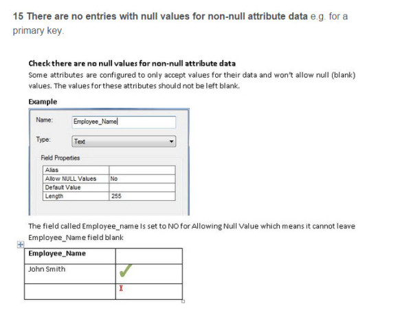

A section of Nathan Heazlewood's very useful 30 checks for data errors.
Labels
You must be a registered user to add a comment. If you've already registered, sign in. Otherwise, register and sign in.
About the Author
I believe that spatial thinking can transform education and society through the application of Geographic Information Systems for instruction, research, administration, and policy.
I hold 3 degrees in Geography, have served at NOAA, the US Census Bureau, and USGS as a cartographer and geographer, and teach a variety of F2F (Face to Face) (including T3G) and online courses. I have authored a variety of books and textbooks about the environment, STEM, GIS, and education. These include "Interpreting Our World", "Essentials of the Environment", "Tribal GIS", "The GIS Guide to Public Domain Data", "International Perspectives on Teaching and Learning with GIS In Secondary Education", "Spatial Mathematics" and others. I write for 2 blogs, 2 monthly podcasts, and a variety of journals, and have created over 5,000 videos on the Our Earth YouTube channel.
Yet, as time passes, the more I realize my own limitations and that this is a lifelong learning endeavor and thus I actively seek mentors and collaborators.
Related Articles
GIS GIGO (Garbage In Garbage Out): 30 checks for data errors
JosephKerski
Esri Notable Contributor
0 Kudos
0 Comments
Labels
-
Administration
38 -
Announcements
44 -
Career & Tech Ed
1 -
Curriculum-Learning Resources
178 -
Education Facilities
24 -
Events
47 -
GeoInquiries
1 -
Higher Education
518 -
Informal Education
265 -
Licensing Best Practices
46 -
National Geographic MapMaker
10 -
Pedagogy and Education Theory
187 -
Schools (K - 12)
282 -
Schools (K-12)
184 -
Spatial data
24 -
STEM
3 -
Students - Higher Education
231 -
Students - K-12 Schools
85 -
Success Stories
22 -
TeacherDesk
1 -
Tech Tips
83
- « Previous
- Next »