Turn on suggestions
Auto-suggest helps you quickly narrow down your search results by suggesting possible matches as you type.
Cancel
- Home
- :
- All Communities
- :
- Industries
- :
- Education
- :
- Education Blog
- :
- Finding Map Content and Understanding What You've ...
Finding Map Content and Understanding What You've Found
Subscribe
226
0
10-20-2016 10:59 PM
- Subscribe to RSS Feed
- Mark as New
- Mark as Read
- Bookmark
- Subscribe
- Printer Friendly Page
- Report Inappropriate Content
10-20-2016
10:59 PM
Finding map content can often be a challenge, even nowadays when so much content is available in ArcGIS Online. Recently, Charlie Fitzpatrick and I taught a a workshop entitled "Key Strategies for Finding Content and Understanding What You've Found." The goal of this activity was to enable GIS-using educators and their students to understand what spatial analysis is, effectively find spatial data, use spatial data, and become familiar with the ArcGIS platform in the process. Based on discussions that take place in GeoNet and elsewhere about this topic, we would like to share it with the broader GIS community. The document is located here.
The document makes it clear that we are still in a hybrid world, where people still need to download data for some work in GIS, but increasingly they are can stream data from cloud-based data services such as those in ArcGIS Online. But these concepts make much more sense when one actually practices doing this--hence the activity.
In the activity, we ask the user to first practice search strategies in ArcGIS Online, using tags and keywords. Then, we guide the user through the process of downloading and using a CSV file with real-time data. After a brief review of data types and resources, we guide the user of the activity through the process of downloading data from a local government agency to solve a problem about flood hazards. The next step asks users to compare this process of downloading data with streaming the same data from the same local government's site (in this case, Boulder County, Colorado) in ArcGIS Online. The activity concludes with resources to discover more about these methods of accessing data.
Other hands-on activities focused on this theme of finding and understanding data exist in the 10 activities included in the Esri Press book, The GIS Guide to Public Domain Data, shown here, and in selected SpatiaLABS and LearnGIS lessons. I look forward to hearing your comments and we hope the activity is useful.
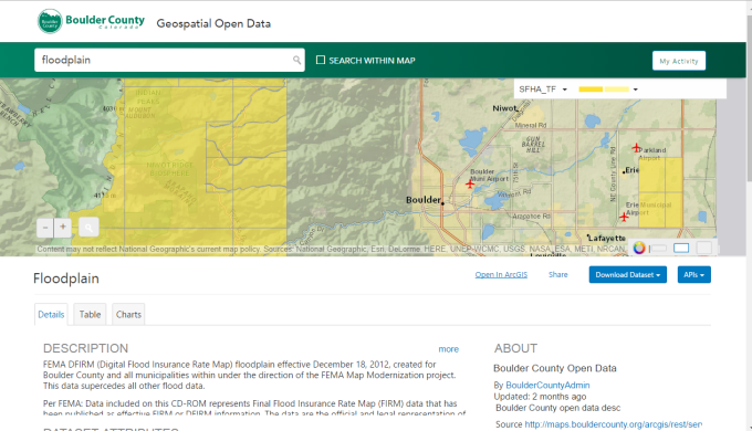
- Accessing data from the Boulder County local government GIS portal through the lesson described above.
You must be a registered user to add a comment. If you've already registered, sign in. Otherwise, register and sign in.
About the Author
I believe that spatial thinking can transform education and society through the application of Geographic Information Systems for instruction, research, administration, and policy.
I hold 3 degrees in Geography, have served at NOAA, the US Census Bureau, and USGS as a cartographer and geographer, and teach a variety of F2F (Face to Face) (including T3G) and online courses. I have authored a variety of books and textbooks about the environment, STEM, GIS, and education. These include "Interpreting Our World", "Essentials of the Environment", "Tribal GIS", "The GIS Guide to Public Domain Data", "International Perspectives on Teaching and Learning with GIS In Secondary Education", "Spatial Mathematics" and others. I write for 2 blogs, 2 monthly podcasts, and a variety of journals, and have created over 5,000 videos on the Our Earth YouTube channel.
Yet, as time passes, the more I realize my own limitations and that this is a lifelong learning endeavor and thus I actively seek mentors and collaborators.
Labels
-
Administration
38 -
Announcements
44 -
Career & Tech Ed
1 -
Curriculum-Learning Resources
177 -
Education Facilities
24 -
Events
46 -
GeoInquiries
1 -
Higher Education
518 -
Informal Education
264 -
Licensing Best Practices
46 -
National Geographic MapMaker
10 -
Pedagogy and Education Theory
187 -
Schools (K - 12)
282 -
Schools (K-12)
183 -
Spatial data
24 -
STEM
3 -
Students - Higher Education
231 -
Students - K-12 Schools
84 -
Success Stories
22 -
TeacherDesk
1 -
Tech Tips
83
- « Previous
- Next »