- Home
- :
- All Communities
- :
- Industries
- :
- Education
- :
- Education Blog
- :
- FAQ for ArcGIS Notebooks in the Cloud (ArcGIS Onli...
FAQ for ArcGIS Notebooks in the Cloud (ArcGIS Online)
- Subscribe to RSS Feed
- Mark as New
- Mark as Read
- Bookmark
- Subscribe
- Printer Friendly Page
- Report Inappropriate Content
The following FAQ will answer some of your commonly asked questions as it relates to using ArcGIS Notebooks in the cloud (ArcGIS Online). This list will continually be updated.
Introduction to ArcGIS Notebooks
Q: What is ArcGIS Notebooks?
A: ArcGIS Notebooks provides a Jupyter notebook experience optimized for spatial analysis.
Q: What are benefits of using ArcGIS Notebooks?
A: ArcGIS Notebooks ships with hundreds of open source Python libraries alongside the ArcGIS Python libraries, ArcPy, and the ArcGIS API for Python. Other benefits include:
- Provide easy sharable, consistent Python environment.
- Reduces time spent in managing dependencies.
- Direct access to web maps and apps.
Q: What are options to work with ArcGIS Notebooks in the ArcGIS platform?
A: Options to work with ArcGIS Notebooks in ArcGIS platform are:
- ArcGIS Notebooks for Enterprise (server)
- ArcGIS Notebooks in the cloud (ArcGIS Online)
- ArcGIS Notebooks in ArcGIS Pro (workstation)
- ArcGIS Notebooks for Developers (Builder plan and higher)
Q: What are the differences between ArcGIS Notebooks Standard, Advanced and Advanced with GPU Support?
- Standard– includes the ArcGIS API for Python and hundreds of open source libraries; appropriate for administrative tasks, data engineering, and light analytics. While standard notebooks themselves are free to create and run, anything that would ordinarily consume credits in ArcGIS Online still does when performed in a notebook (running analysis or accessing premium content).
- Advanced– includes everything offered in Standard plus ArcPy; offers a larger instance size (more compute and memory resources); appropriate for most workflows including large scale data engineering, advanced analytics and some machine learning workflows; credit rates apply.
- Advanced with GPU– includes everything in Standard and Advanced along with a GPU powered instance that offers the highest amount of compute and memory resources; appropriate for computationally intensive workflows such as big data analytics, model training and model inferencing; credit rates apply.
Enabling Access to ArcGIS Notebooks
Q: Is a custom role needed to enable ArcGIS Notebooks access? How do I enable access to ArcGIS Notebooks for all the members in ArcGIS Online?
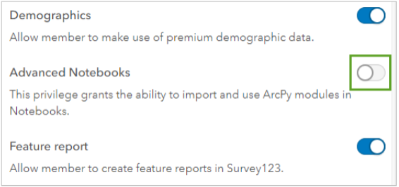
A: Notebook privileges are assigned through the role settings. To assign privileges that allow users to access standard or advanced notebooks in ArcGIS Notebooks, you’ll need to create a custom role in your ArcGIS Online Settings (by Administrator). You can create the custom role based on any of the default roles such as Publisher role. Once a new custom role is created, you will need to add notebook create and user privileges to your new custom role:
- Under Role privileges, expand the Content group and turn on Create and edit notebooks. This allows the user to create and edit standard notebooks.
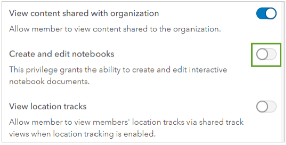
- Expand the Premium content group and turn on Advanced Notebooks. This allows the user to create Advanced Notebooks that use ArcPy or access the GPU-enabled notebook runtime.
Once you’ve created a custom role with Advanced Notebooks enabled, you can make that role the default role for new users (Settings > New member defaults). All users joining the organization from this point forward will automatically have access to ArcGIS Notebooks. You will also need to assign that custom role to the existing members.
Q: Is there documentation on how to set up access to ArcGIS Notebooks I can give to my Administrator?
A: Yes. This PDF lesson provides a step-by-step instruction on how to setup access to ArcGIS Notebooks by an Administrator.
Q: Is there any way to control this default setting? It seems like if you enabled Advanced access, when you spin up a Notebook, it defaults to Advanced. Can the default change to Standard, even for users with Advanced access?
A: No, not with the current release. The Product team is working on a new launch experience that will make it easier for users to not accidentally pick an advanced runtime if that is not what they desire.
Credits Calculation
Q: How is credit usage calculated with Advanced and Advanced with GPU?
A: Credit is charged per minute so if you divide those rates listed in the doc by 60, you will get the per minute pricing. Knowing the hourly rates makes it easier to do quick estimation.
Use this as a reference:
Standard: 0 credits/minute
$0 USD/minute
Advanced: .05 credits/minute
$0.005 USD/minute
Advanced with GPU: .5 credits/minute
$0.05 USD /minute
Q: Can you give examples of credit usage for using ArcGIS Notebooks for a class?
A: The credit usage will depend on the amount of time Notebooks are used. It also depends on the number of users and whether Notebooks are being used a few hours a week in a class or being used in a research project (many hours per week for an entire year).
For example, if a class of 20 students uses Notebooks for an average of 4 hours per week for a 16-week long course, the credit usage would be:
- Advanced Notebooks: 3,840 credits total for course = 20 students x 4 hours x 16 weeks = 1,280 hours = 76,800 minutes @ 0.05 credits/min
- Advanced Notebooks with GPU: 38,400 credits total for course = 20 students x 4 hours x 16 weeks = 1,280 hours = 76,800 minutes @ 0.5 credits/min
If an individual researcher uses Notebooks an average of 20 hours per week for a year (excluding a 4-week vacation), the credit usage would be:
- Advanced Notebooks: 2,880 credits total for course = 1 researcher x 20 hours x 48 weeks = 960 hours = 57,600 minutes @ 0.05 credits/min
- Advanced Notebooks with GPU: 28,800 credits total for course = 1 researcher x 20 hours x 48 weeks = 960 hours = 57,600 minutes @ 0.5 credits/min
Thus, in a classroom setting, you may want to budget 200-500 credits per student for Advanced Notebooks or 2,000 – 5,000 credits per student for Advanced+GPU.
In a research setting, you might want to budget 3,000 – 5,000 credits per person for Advanced Notebooks or 30,000 – 50,000 credits per person for Advanced+GPU.
Working with ArcGIS Notebooks
Q: How long can a notebook be open before it goes idle and automatically disconnects?
A: 20 minutes. We do not charge for idle time, credits are calculated based on the last activity within the notebook.
Q: What happens if I forgot to close the Notebooks?
A: The notebook will time out and disconnected after 20 minutes of being idle.
Q: Can I use local data with ArcGIS Notebooks in ArcGIS Online?
A: Yes, you can. On the Files component in ArcGIS Notebooks, you can upload your local data into /arcgis/home. You can also use the Python API to create a new folder and add data there.
Q: Can I create a new file folder under Files?
A: Yes, but you must do it using the ArcGIS API for Python. Adding new files to this location will also require the use of Python code.
Q: Is there a limit to how much data (rasters, shapefile, file geodatabases) I can upload into ArcGIS notebooks?
A: This depends on how you bring in data, using the ArcGIS API for Python to add data will allow you to bring in larger file sizes. The current file size limit using the upload UI under Files is 20MB. A new big file uploader is on the roadmap to increase the file size allowed by the upload UI.
Q: Can you schedule notebooks?
A: No, not with the current release.
Q: Can I download a notebook from ArcGIS Online?
A: Yes, here are two options:
1) In the Notebook, under File > Download As
2) Find the notebook item in your Content > Open the item details page > Click Download button
Q: Can I upload a notebook into ArcGIS Online?
Yes, In the Content, choose Add Item > From your computer. It will add as a new item. Be aware that any notebook uploaded will automatically use your default runtime unless you explicitly change it in the Item Details page.
Q: Are there some samples Notebooks? Where can I find them?
A: Samples are included in ArcGIS Notebooks. There is a link to the Samples on the top right of your Notebooks in ArcGIS Online.

There are sample notebooks for categories: data science and analysis, content management and ArcGIS Online administration.
ArcGIS Notebooks Resources
Q: Do you have resources for teaching with ArcGIS Notebooks?
A: Yes. Learn ArcGIS provides a learning path for teaching with ArcGIS Notebooks. You can also refer to this webpage for educators.
Q: Do we have resources for self-learning ArcGIS Notebooks?
A: The MOOC, Spatial Data Science: The New Frontier in Analytics uses ArcGIS Notebooks to teach Spatial Data Science. There are also several new Learn lessons under development.
Q: Is there a community where I can post questions or get more information?
A: You can join ArcGIS Notebooks community on Esri GeoNet and follow ArcGIS Analysis on Twitter.
Q: Where can I find more product information and resources on ArcGIS Notebooks?
A: Visit ArcGIS Notebooks product page.
Q: Who can I contact if I have additional questions about accessing ArcGIS Notebooks in my university?
A: You can contact highered@esri.com
Q: How do I submit an enhancement request or report a bug?
A: Bugs should be reported through tech support, enhancement requests can also be submitted through tech support. Additionally, you can use the GeoNet community to share ideas and engage with the broader ArcGIS Notebooks community.
You must be a registered user to add a comment. If you've already registered, sign in. Otherwise, register and sign in.
-
Administration
38 -
Announcements
45 -
Career & Tech Ed
1 -
Curriculum-Learning Resources
179 -
Education Facilities
24 -
Events
47 -
GeoInquiries
1 -
Higher Education
519 -
Informal Education
266 -
Licensing Best Practices
46 -
National Geographic MapMaker
17 -
Pedagogy and Education Theory
187 -
Schools (K - 12)
282 -
Schools (K-12)
185 -
Spatial data
24 -
STEM
3 -
Students - Higher Education
231 -
Students - K-12 Schools
86 -
Success Stories
22 -
TeacherDesk
1 -
Tech Tips
83
- « Previous
- Next »