Turn on suggestions
Auto-suggest helps you quickly narrow down your search results by suggesting possible matches as you type.
Cancel
- Home
- :
- All Communities
- :
- Industries
- :
- Education
- :
- Education Blog
- :
- Comparing a GPS vs. SmartPhone, Part 2 of 2
Comparing a GPS vs. SmartPhone, Part 2 of 2
Subscribe
1126
0
04-22-2011 08:21 AM
- Subscribe to RSS Feed
- Mark as New
- Mark as Read
- Bookmark
- Subscribe
- Printer Friendly Page
- Report Inappropriate Content
04-22-2011
08:21 AM
Recently, I wrote about my comparison of the horizontal position obtained from a consumer-grade GPS receiver versus that obt.... Specifically, I compared a Garmin GPS 76 to an iPhone 4. The position recorded on my iPhone was consistently tens-of-meters off from the position recorded with my GPS receiver. Thus far, it appeared that my position as recorded by my GPS receiver is far more accurate than that from my iPhone. However, this was not the end of the story.
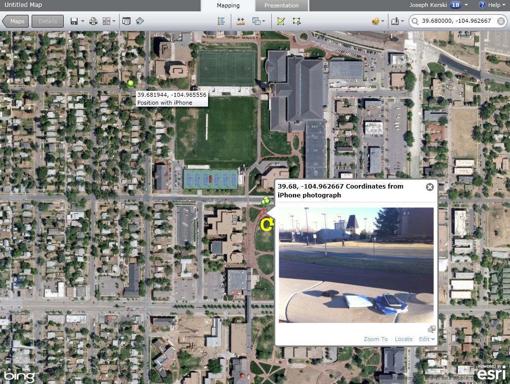
In the field, I switched to the map view on my phone, and the blue dot marking my current position was not hundreds of meters away, but just a few meters from where I was standing. I took a photograph here and emailed it to my PicasaWeb account using the procedures I wrote about in a previous blog column.
This photograph was geotagged at 39.680000 north latitude, 104.962667 west longitude, which turned out to be only 6.21 meters away (this time to the southwest) from my position as recorded by the GPS receiver. Interesting! This means that the SmartPhone was indeed recording an accurate position, but perhaps the app used to capture that position may have compromised that position.
The map I created from ArcGIS Explorer Online below shows my hyperlinked photograph very near to the position where I conducted the experiment, and several blocks to the northwest is the position recorded by the default compass utility in my phone.
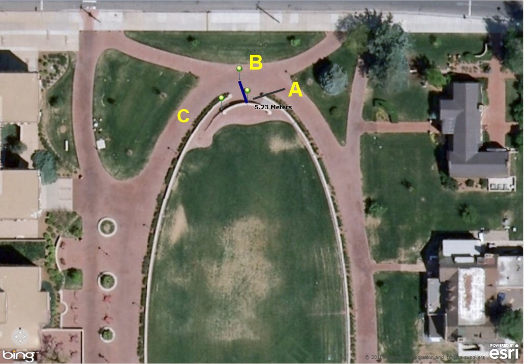
Zooming in, Pushpin A at the end of the green line points to where I stood at the brick wall on campus. Pushpin B, 5.23 meters north-northwest, is the position recorded with my GPS receiver, and Pushpin C, 6.21 meters to the west-southwest, is the geotagged position recorded in the photograph I took at that spot.
Your results will vary with the tools, including the types of WebGIS, GPS, and SmartPhone used. For example, a higher-end GPS such as a Trimble or TopCon will surely provide better horizontal accuracy. Also, would my iPhone position have been any better if I had used a GPS app instead of the default compass tool in my phone?
All of these technologies will continue to undergo rapid change, providing ample opportunity for further experiments. These types of experiments connect mathematics, GIScience (including discussion on datums, coordinate systems, and data quality), and geography. How might you turn these activities into teachable moments and activities?
- Joseph Kerski, Education Manager
In the field, I switched to the map view on my phone, and the blue dot marking my current position was not hundreds of meters away, but just a few meters from where I was standing. I took a photograph here and emailed it to my PicasaWeb account using the procedures I wrote about in a previous blog column.
This photograph was geotagged at 39.680000 north latitude, 104.962667 west longitude, which turned out to be only 6.21 meters away (this time to the southwest) from my position as recorded by the GPS receiver. Interesting! This means that the SmartPhone was indeed recording an accurate position, but perhaps the app used to capture that position may have compromised that position.
The map I created from ArcGIS Explorer Online below shows my hyperlinked photograph very near to the position where I conducted the experiment, and several blocks to the northwest is the position recorded by the default compass utility in my phone.
Zooming in, Pushpin A at the end of the green line points to where I stood at the brick wall on campus. Pushpin B, 5.23 meters north-northwest, is the position recorded with my GPS receiver, and Pushpin C, 6.21 meters to the west-southwest, is the geotagged position recorded in the photograph I took at that spot.
Your results will vary with the tools, including the types of WebGIS, GPS, and SmartPhone used. For example, a higher-end GPS such as a Trimble or TopCon will surely provide better horizontal accuracy. Also, would my iPhone position have been any better if I had used a GPS app instead of the default compass tool in my phone?
All of these technologies will continue to undergo rapid change, providing ample opportunity for further experiments. These types of experiments connect mathematics, GIScience (including discussion on datums, coordinate systems, and data quality), and geography. How might you turn these activities into teachable moments and activities?
- Joseph Kerski, Education Manager
You must be a registered user to add a comment. If you've already registered, sign in. Otherwise, register and sign in.
About the Author
I believe that spatial thinking can transform education and society through the application of Geographic Information Systems for instruction, research, administration, and policy.
I hold 3 degrees in Geography, have served at NOAA, the US Census Bureau, and USGS as a cartographer and geographer, and teach a variety of F2F (Face to Face) (including T3G) and online courses. I have authored a variety of books and textbooks about the environment, STEM, GIS, and education. These include "Interpreting Our World", "Essentials of the Environment", "Tribal GIS", "The GIS Guide to Public Domain Data", "International Perspectives on Teaching and Learning with GIS In Secondary Education", "Spatial Mathematics" and others. I write for 2 blogs, 2 monthly podcasts, and a variety of journals, and have created over 5,000 videos on the Our Earth YouTube channel.
Yet, as time passes, the more I realize my own limitations and that this is a lifelong learning endeavor and thus I actively seek mentors and collaborators.
Related Articles
Comparing a GPS vs. SmartPhone, Part 1 of 2
JosephKerski
Esri Notable Contributor
0 Kudos
0 Comments
Labels
-
Administration
38 -
Announcements
45 -
Career & Tech Ed
1 -
Curriculum-Learning Resources
179 -
Education Facilities
24 -
Events
47 -
GeoInquiries
1 -
Higher Education
519 -
Informal Education
266 -
Licensing Best Practices
46 -
National Geographic MapMaker
11 -
Pedagogy and Education Theory
187 -
Schools (K - 12)
282 -
Schools (K-12)
185 -
Spatial data
24 -
STEM
3 -
Students - Higher Education
231 -
Students - K-12 Schools
86 -
Success Stories
22 -
TeacherDesk
1 -
Tech Tips
83
- « Previous
- Next »