Turn on suggestions
Auto-suggest helps you quickly narrow down your search results by suggesting possible matches as you type.
Cancel
- Home
- :
- All Communities
- :
- Industries
- :
- Education
- :
- Education Blog
- :
- Break On Through to the Other Side: Routing Around...
Break On Through to the Other Side: Routing Around Barriers
Subscribe
344
0
07-11-2013 11:24 PM
- Subscribe to RSS Feed
- Mark as New
- Mark as Read
- Bookmark
- Subscribe
- Printer Friendly Page
- Report Inappropriate Content
07-11-2013
11:24 PM
I recently created a set of activities based on using web-based GIS tools to teach spatial thinking using drive-time buffers, a set of activities that use viewsheds as a teaching tool, another on the use of zonal statistics, and another on analyzing the best route to a facility. Each of these shares common elements: They are all based on Esri GIS technology. They are all free, easy to use, powerful, and they foster spatial thinking. Let's use another GIS tool to investigate routing around barriers. Barriers may be physical, such as ridges or rivers, or they may be a human construct or consequence, such as one-way streets, road repair, or an accident.
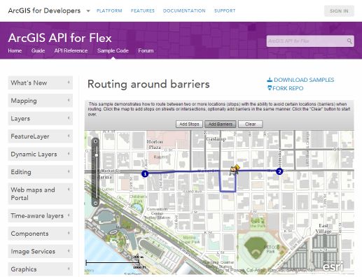
Examine the routing around barriers mapping application. Let's say you are running a bicycle courier service in downtown San Diego. Your pick up point is at 1st Avenue and Market Street. Your destination is at 10th Avenue and Market Street. Add these 2 stops and have the map calculate your route, shown in blue. But now say there is construction at 7th Avenue and Market. Use Add Barriers and add a barrier at 7th Avenue and Market (3 blocks due west of 10th and Market).
What changed on your map after you added a barrier, and why? Experiment with additional barriers in different locations around downtown San Diego. Zoom out and repeat the operation with a slightly different scenario at this new scale: Now you're in a truck filled with trees that you must deliver around metropolitan San Diego. How can you most efficiently deliver your trees to 4 urban gardens around the city? Add barriers and observe how they change your route's pattern. How much additional time do you estimate would be required to make your deliveries with these new barriers?
How might you be able to use this tool in your instruction to foster spatial thinking?

Routing around barriers
Examine the routing around barriers mapping application. Let's say you are running a bicycle courier service in downtown San Diego. Your pick up point is at 1st Avenue and Market Street. Your destination is at 10th Avenue and Market Street. Add these 2 stops and have the map calculate your route, shown in blue. But now say there is construction at 7th Avenue and Market. Use Add Barriers and add a barrier at 7th Avenue and Market (3 blocks due west of 10th and Market).
What changed on your map after you added a barrier, and why? Experiment with additional barriers in different locations around downtown San Diego. Zoom out and repeat the operation with a slightly different scenario at this new scale: Now you're in a truck filled with trees that you must deliver around metropolitan San Diego. How can you most efficiently deliver your trees to 4 urban gardens around the city? Add barriers and observe how they change your route's pattern. How much additional time do you estimate would be required to make your deliveries with these new barriers?
How might you be able to use this tool in your instruction to foster spatial thinking?
You must be a registered user to add a comment. If you've already registered, sign in. Otherwise, register and sign in.
About the Author
I believe that spatial thinking can transform education and society through the application of Geographic Information Systems for instruction, research, administration, and policy.
I hold 3 degrees in Geography, have served at NOAA, the US Census Bureau, and USGS as a cartographer and geographer, and teach a variety of F2F (Face to Face) (including T3G) and online courses. I have authored a variety of books and textbooks about the environment, STEM, GIS, and education. These include "Interpreting Our World", "Essentials of the Environment", "Tribal GIS", "The GIS Guide to Public Domain Data", "International Perspectives on Teaching and Learning with GIS In Secondary Education", "Spatial Mathematics" and others. I write for 2 blogs, 2 monthly podcasts, and a variety of journals, and have created over 5,000 videos on the Our Earth YouTube channel.
Yet, as time passes, the more I realize my own limitations and that this is a lifelong learning endeavor and thus I actively seek mentors and collaborators.
Labels
-
Administration
38 -
Announcements
45 -
Career & Tech Ed
1 -
Curriculum-Learning Resources
179 -
Education Facilities
24 -
Events
47 -
GeoInquiries
1 -
Higher Education
519 -
Informal Education
266 -
Licensing Best Practices
46 -
National Geographic MapMaker
17 -
Pedagogy and Education Theory
187 -
Schools (K - 12)
282 -
Schools (K-12)
185 -
Spatial data
24 -
STEM
3 -
Students - Higher Education
231 -
Students - K-12 Schools
86 -
Success Stories
22 -
TeacherDesk
1 -
Tech Tips
83
- « Previous
- Next »