The Esri Development Center (EDC) program confers special status and benefits upon a select few leading university departments that challenge their students to develop innovative applications based upon the ArcGIS platform and related elements of the geospatial technology ecosystem. One benefit of the program is a cash prize, certificate, and Esri Press book awarded to a Student of the Year named by each EDC. Here I’ll share brief profiles of 10 outstanding award winners, including the one student selected as Esri's 2018 International Student of the Year.
Susanna Ambondo Abraham, Technische Universität (TU) Dresden

Susanna is employed as a Cartographer at the Ministry of Mines and Energy in Namibia
For her International Master of Science in Cartography thesis “Historical Spatio-temporal data in current GIS, Case Study: German-Herero war of resistance 1904”, Susanna applied Natural Language Processing techniques to extract spatio-temporal data from unstructured historical text documents. Using the GATE text engineering architecture, Susanna developed tools to perform gazetteer matching and spatiotemporal relationship extraction, as well as pattern-based rules to recognize and annotate elements. She then used ArcGIS to analyze the extracted historical spatio-temporal data. Reviewers observed that “the project requires expertise in natural language processing, geographic positioning, spatio-temporal analysis, and history, and addresses a timeless issue – human conflict.” Her research will be reported in a special issue of the Transactions in GIS. Meanwhile, this
story map summarizes Susanna's findings.
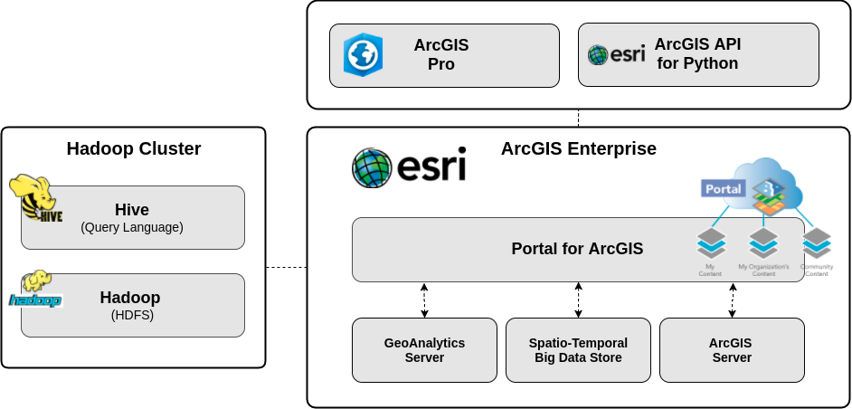
Marlena Götza, University of Münster
Marlena’s masters project at the Institute for Geoinformatics (ifgi) involved a collaboration between 52° North, Esri, and the company CLAAS E-Systems. CLAAS’ Telematics system uses a big data infrastructure to delineate farm fields from the movements of agricultural vehicles. Farm field boundaries provide the basis for automated planning and control tasks for farmers. The problem is that CLAAS' infrastructure does not provide geo-functionalities that take into account the spatial context in managing and processing the data. The purpose of Marlena's study was therefore to determine how the existing Big Data infrastructure could be enhanced by Esri technology.
Overview of the extended system infrastructure Marlena Götza tested for CLAAS E-Systems.
For field boundary detection, the existing Hadoop infrastructure was extended through the ArcGIS Enterprise platform. In addition to the ArcGIS Enterprise Stack, the configuration also includes ArcGIS Pro, which allows to users to control processing on ArcGIS Enterprise and to define processing workflows. The project demonstrated the added value of ArcGIS for visualization and spatio-temporal data, and also identified potential improvements to GeoAnalytics Server and the Big Data Store for similar applications.
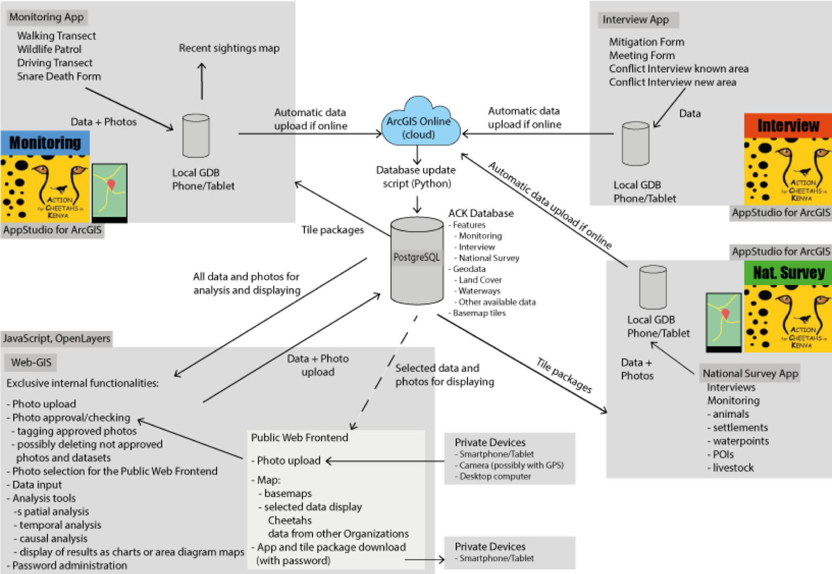
Jan Jedersberger, Karlsruhe University of Applied Science
For his masters thesis "Conceptualizing and implementing mobile mapping tools to support cheetah monitoring in Kenya”, Jan used AppStudio for ArcGIS and Qt/QML to develop a suite of mobile field apps, a web app, and back-end capabilities. Reviewers noted that “Jan built a complex distributed system for a worthy cause."
Jan (left) confers with a staff member of the NGO Action for Cheetahs in Kenya (ACK) about usability of the mobile apps he developed. At right, an ACK staffer photographs and tags a cheetah track.
Relationships among components of the system Jan Jedersberger developed for Action for Cheetahs in Kenya.
Timo Staub, University of Applied Sciences Würzburg-Schweinfurt
Timo developed a 3D route planning system for the University’s Röntgenring campus information system. Users can search start and end points by room number. Options include avoiding elevators, stairs, and/or special lock authorizations, and specifying in-building routes. Timo used ArcGIS Desktop, ArcGIS Server, Network Analyst, and ArcGIS Online to create the 3D-Routeplanner app.
 Timo Staub’s 3D-Routeplanner app at the University of Applied Sciences Würzburg-Schweinfurt’s Röntgenring campus.
Nicole Helgeson, University of Minnesota
Nicole is a second-year student in the University of Minnesota’s Master of GIS program. She’s also a research assistant with the University’s Extension Center for Family Development. She earned the EDC Student of the Year award for her work in web mapping and web GIS—specifically related to health and nutrition. Nicole's nominators remarked that although Nicole “did not have a computer science or software engineering background … she has become our archetype for how a student can migrate from GIS applications into GIS development."

Nicole interns with a local county Public Health agency, volunteers for the Minnesota Food Charter, and has received funding from the university’s Healthy Foods, Healthy Lives Institute. The web mapping sites she’s developed for these agencies deal directly with food access or cataloging institutions concerned with food access. A common feature is the integration crowdsourced information, primarily using Survey123 for ArcGIS. One example is
Ramsey County food resources.
Timothy Naegeli, Penn State University
For his Master of GIS capstone project, Tim collaborated with a plenary geologist at the U.S.Geological Survey to develop and test a new GIS-based tool for identifying and characterizing impact craters on Mars and the Moon. Planetary geologists study primary and secondary impact craters to determine the ages of celestial bodies. Tim developed an extension to the Large Crater Clustering (LCC) tool set that enables analysts to simulate impact trajectories and identify likely locations of primary and secondary craters. The extension – a Python script that levers ArcGIS’ ArcPy library – is described in
Tim’s paper in Computers and Geosciences.
 Simulated impact trajectories reveal likely locations of primary craters in the Lunae Pauls quadrangle on Mars.
Brian Ho, Harvard University

Brian Ho, Harvard Graduate School of Design and School of Engineering and Applied Sciences Brian's project seeks nothing less than to to define a "new mode of geographic analysis" that "unites the [planimetric] view from above and the [street]view from the ground.” The project is grounded in Kevin Lynch’s Image of the City, a landmark study that relied on both systematic field reconnaissance and interviews with a small sample of city residents, all supported by photographs, hand-drawn maps and lengthy transcripts. Lynch’s five elements of the city image — the path, edge, district, node and landmark — led to a generalized theory of urban form. For his project, Brian geolocated some 2000 of Lynch’s original photos of Boston. He then used ArcGIS Pro to warp a scanned image of Lynch’s Boston city image diagram, digitized each city image element, then associated the geolocated photos with the elements. Finally, Brian developed a convolutional neural net to learn the relationship between the imagery and the city image elements. A reviewer noted that Brian’s project "requires expertise in disparate domains (AI, geographic analysis, perception) and addresses a timely issue as the world becomes increasingly urban.”
Stefan Zimmer, University of Salzburg
Department of Geoinformatics – Z_GIS – honors Stefan for his masters thesis "An Efficient Algorithm for Computing Space-Time-Linguistics Similarities and Labelling Social Media Posts.” Stefan's machine learning-based algorithm “TwEmLab" (Twitter Emo-tion Labeller) assigns emotion categories to social media posts like tweets. Nominators praised his success in implementing the complex algorithm in a way that outperforms comparable parallelized algorithms, both for CPU- and GPU-based operations.
 Tweets in the Boston vicinity associated with anger/disgust (red), fear (blue), and sadness (yellow), according to Zimmer’s algorithm.
Stefan applied exceptional software development skills to develop and implement geospatial applications using a variety of software technologies, including extensive use of Esri technology for spatial data analysis and visualization. He conceived and implemented a location-based game, in which a spaceship can be controlled using a mobile EEG device and voice commands, and was a member of the successful team winning the first Copernicus Hackathon.
Abhinav Mehrotra, University College London
Abhinav earned his PhD with a dissertation titled “A framework for intelligent mobile notifications.” His work focuses on the collection and analysis of large-scale datasets from mobile and wearable devices. He is also interested in the analysis of mobile GPS traces to extract human mobility patterns and exploit this information to support innovative services. "My research,” Abhinav writes, "is driven by a strong desire to provide value to the smartphone users from the data generated by their phones.”
ArcGIS played an important role in his projects, especially for visualizing mobility trajectories and understanding the characteristics of the places visited by the users considered in his studies. For example, in a recent project that investigates the impact of places on users' mobile interaction behavior, ArcGIS has been a key tool for clustering places visited by users over time. Nominators remarked that “the results of this work could prove to be of key importance for the development of novel intelligent mobile applications and services and also for mobile application marketing purposes.” Abhinav’s co-authored paper "Understanding the Role of Places and Activities on Mobile Phone Interaction and Usage Patterns” is published in the
Proceedings of the ACM on Interactive, Mobile, Wearable and Ubiquitous Technologies.
Nicholas Romano, University of Maryland
Nick is a second year student in Maryland’s Master of Professional Studies in Geospatial Information Sciences program. He currently serves as a Graduate Assistant within the Campus GIS Group in Facilities Management. His development portfolio focuses on web development using the ArcGIS for JavaScript API, and data management and interoperability utilizing Python and the ArcPy package. He has developed a tool that repairs CAD files to re-enable block attributes that can be read within ArcGIS 10.3 and above. His other tools automate the transformation of CAD building floorplan data into the Local Government Information Model (LGIM), allowing them to be utilized for visualization within 3D Web Scenes and for interior navigation. At the 2018 Esri Developers Summit in Palm Springs, Nick proposed new methods to organize and scale enterprise application code. Along with his colleagues and predecessors, Nick helps make the
University of Maryland Campus Web Map one of the best of its kind.

Nick Romano’s 3D Interior Navigation prototype app
Last but not least, we are pleased to announce our 2018 Esri Development Center International Student of the Year:
Ashwin Shashidharan North Carolina State University
Ashwin Shashidharan (center) with advisers Ross Meentemeyer (left) and Raju Vatsavai.
Ashwin’s pathbreaking work in high performance computing for geosimulations earned first place in the student research competition at the 24th ACM SIGSPATIAL Conference. A PhD candidate in Computer Science, Ashwin is advised jointly by Ross Meentemeyer, director of NC State’s Center for Geospatial Analytics, and Faculty Fellow Raju Vatsavai.
During an earlier internship with Esri, Ashwin contributed to algorithm design and software development of a spatial indexing library for GPGPUs. This work involved C/C++ programming using the NVIDIA’s CUDA parallel computing platform and programming model for NVIDIA GPUs. This work was part of Esri’s GPU computing initiative to extend big data analysis with the ArcGIS GeoAnalytics software. Reviewers noted that "Ashwin is working on the bleeding edge of GPU-based geoanalytics within the ArcGIS platform."
Time, space and available documentation do not permit profiles of every Student of the Year. Congratulations to honorees at other Esri Development Centers:
Max Czapanskiy and
Sally Shatford (co-winners), San Francisco State University
David Penn, Georgia Southern University
Nikhil Sangwan, Purdue University, for his project on validation of floodmaps at county resolution for the entire U.S.
Matthias Stein, Hochschule Bochum, for his master thesis project "Usability improvements for map content controls on mobile devices."
Jorim Urner, Institute of Cartography and Geoinformation, ETH Zurich, for his thesis project Incorporating Spatio-Temporal Context for Predicting the Next Place Using Neural Networks and Random Forests and contributions to the
GoEco project.