- Home
- :
- All Communities
- :
- Industries
- :
- Education
- :
- Education Blog
- :
- 1-Click to Content: Gallery Applications in ArcGIS...
1-Click to Content: Gallery Applications in ArcGIS Online
- Subscribe to RSS Feed
- Mark as New
- Mark as Read
- Bookmark
- Subscribe
- Printer Friendly Page
- Report Inappropriate Content
Gallery Applications for Curated Content Access
ArcGIS Online offers users the ability to create maps and applications for an entire enterprise. As the number of named users increases across a utility or company, the amount of content can increase rapidly and there is a stronger need for content management to ensure that users can find and access the maps and applications they need.
View a video of the demonstration.
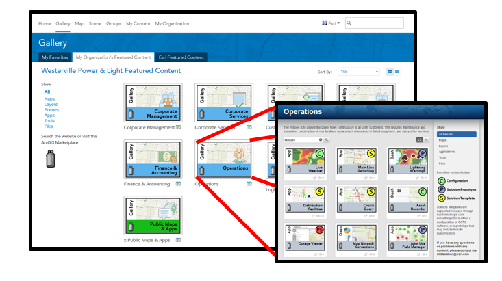
One of the tools that can help with content dissemination and end user experience is the Public Gallery Application. Using your group settings, the application lets administrators control how their users interact with and discover content. In the screenshot below, a utility has Gallery Applications for all of their departments. As a user clicks on the Operations application, it launches a Gallery Application view of the Operations group with content filtered to hide feature services, maps, and other content. Users are no longer overwhelmed with hundreds of maps and services, just a curated list of useful tools.
Groups
While Groups in ArcGIS Online offer a structure for sharing content and controlling access, they do not provide the best framework for providing users direct access to that content.
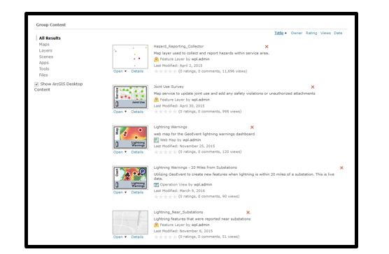
Very quickly, groups can become unruly as you share services, maps, documents, apps, and more to those groups. Asking novice users to navigate through these groups could cause confusion or frustration. The screenshot below is from an Operations group with over 60 items.
Groups still provide the foundation for what content users have permission to access, but they do not provide the best user interface for navigating through that content.
Gallery Applications to the Rescue
One way to control the types of content that users have access to is by creating a Public Gallery web application from the group. Basically, using a Gallery Application allows users to create a curated view of a specific group based on item types or tags.
While you are in the group you want to work with, click the Share button, select Create a Web App, and choose Public Gallery. This will create a new application for you.
There are a number of options to configure the look and feel of the Gallery Application, but the most important settings are in the Gallery Options tab. Here, you can control the types of items that will appear in the application, the number of items, the way they will appear, or you can use a search string to limit what items are shown. Using the search string option, you could place a ‘Featured’ tag on all items in a group that would act as a filter, as shown in the screenshot below.
In the Enable Features tab, one setting to note is the “Show a list allowing users to filter by items type”. With this setting enabled, users have the ability to filter what they are seeing to maps, apps, dashboards, or other item types. This combined with the tag search string provides powerful functionality for providing a curated, filtered view of items to your users.
After you Publish your application, it’s sharing can be controlled just like any other organizational item. As depicted in the first screenshot, you could share your Gallery Application to the Featured Content group to create a list of all departments. Or, you could start nesting Public Gallery applications in other groups, to create a Gallery Application of Gallery Applications.
Closing
The Gallery Applications offer a range of possibilities for how administrators can begin to create custom views of content shared into groups. Rather than forcing users to navigate through content heavy groups, they can be provided with a clean user interface that lets them quickly discover the content they need.
If you have any questions, please feel free to contact me at: bbaldwin@esri.com
You must be a registered user to add a comment. If you've already registered, sign in. Otherwise, register and sign in.
-
Administration
38 -
Announcements
44 -
Career & Tech Ed
1 -
Curriculum-Learning Resources
178 -
Education Facilities
24 -
Events
47 -
GeoInquiries
1 -
Higher Education
518 -
Informal Education
265 -
Licensing Best Practices
46 -
National Geographic MapMaker
10 -
Pedagogy and Education Theory
187 -
Schools (K - 12)
282 -
Schools (K-12)
184 -
Spatial data
24 -
STEM
3 -
Students - Higher Education
231 -
Students - K-12 Schools
85 -
Success Stories
22 -
TeacherDesk
1 -
Tech Tips
83
- « Previous
- Next »