- Home
- :
- All Communities
- :
- Developers
- :
- Developers - General
- :
- Developers Questions
- :
- Re: Accessing M-N and 1-M related table records in...
- Subscribe to RSS Feed
- Mark Topic as New
- Mark Topic as Read
- Float this Topic for Current User
- Bookmark
- Subscribe
- Mute
- Printer Friendly Page
Accessing M-N and 1-M related table records in Portal Pop-ups
- Mark as New
- Bookmark
- Subscribe
- Mute
- Subscribe to RSS Feed
- Permalink
- Report Inappropriate Content
Hello, I'm an Arcade newbie trying to modify the pop up for the parcels in a web map that serves as the basis for a Portal web application. The parcels feature layer in question has a pairing of relationship classes set up to other tables in the published Map Service. This Service, called "TL_Parcels_Activities" is added to the web map and called "Tidelands Activities" in the Contents.
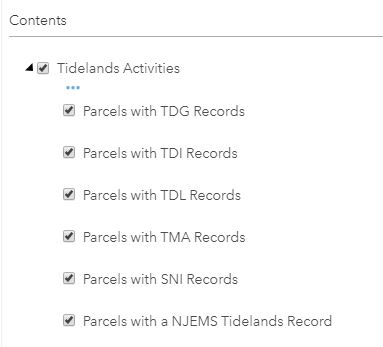
It contains six different items with a different definition query on the parcels source data, a feature class in our geodatabase called "TL_Parcels".
TL_Parcels has a Many-to-Many relationship to the PI Numbers table, which, in turn, has a One-to-Many relationship to the Tidelands Activities table.There is also an additional 1-M relationship set up to a Site ID table. All of these tables and relationship class tables were included in the Map Service and show up in the web map.
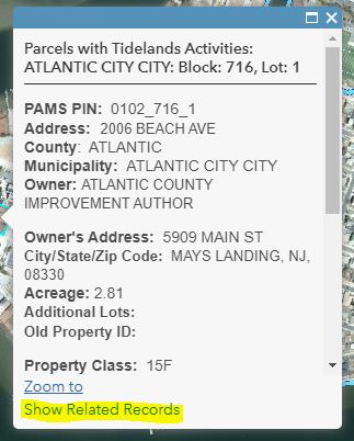
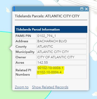
The Related Records show up in the pop-up to open the related data in tabular form well enough...
... but I was hoping to use Arcade to get the related info to appear in the pop-up directly, without having to click and read in the attribute tables themselves.
I found some good examples of script suggestions on GeoNet for some 1-M situations that I tried out. I think folks were using these for AGO, which I understand has some quirky differences from the Portal environment. I started with this sample: How do you reference another field from a related table in Arcade?
My initial attempts kept giving me the error:
"Execution Error:Runtime Error: Identifier Not Found. $map"
I found an example that focused on the GlobalID that I decided to run with and still got the same problem.
Get 1:M related objects using Arcade
// read the GlobalID of the feature
var globalid = $feature.GlobalID;
// create a sql expression to filter the asset table
var sql = "gis_id = '" + globalid + "'";
// Access the Activities based on the name in the map
var ACTIV_view = FeatureSetByName($map, "TL_PINumbers");
// filter the assets using the sql expression
var ACTIV = Filter(ACTIV, sql);
// get the count of the related Activities
var cnt = Count(Activities);
// create a variable to hold the resulting text
var ACTIV_info = "";
// validate if there are any related records and handle accordingly
if (cnt > 0) {
// there is at least 1 related record, create activity info
ACTIV_info = cnt + " Activities:";
// loop through related records
for (var activity in Activities) {
// create text using name and description (you should modify this to match your needs)
var ACTIV_text = " - " + Activity.name + TextFormatting.NewLine + Activity.description;
// add the text for this activity to the activity info
ACTIV_info += TextFormatting.NewLine + ACTIV_text;
}
} else {
// no related records (or the sql query did not work)
ACTIV_info = "No related Activities";
}
return ACTIV_info;With these I could never access the $map from the Globals tab. Despite the fact that all of these other things were in the same web map, all I could see were the $feature for all of the fields in the Parcels feature class.
As a test, I separately published a Hosted Feature Layer of the parcels/relationships which shows the two related tables, but not the relationship classes themselves, within the service.
 Then I added that to my web map and tried to use the same Arcade expression on that layer. $map was now accessible to me in the Globals and the code seemed to get past that sticking point, but gave me an Execution Error: Filter cannot accept this parameter type.
I'm not always exactly sure what the sample scripts are asking for everywhere, so I'm not fully sure I'm putting the correct info where it belongs. I also know that I will probably need to do more to this to add all the attribute info I want to display and probably to get the script to go to the next level for the other 1-M relationship between the two tables.
Thanks.
Solved! Go to Solution.
- Mark as New
- Bookmark
- Subscribe
- Mute
- Subscribe to RSS Feed
- Permalink
- Report Inappropriate Content
Our organization has since updated to Enterprise server 10.8, allowing us to access the FeatureSetByName and FeatureSetByID functions. Re-visiting this, we've been able to write code for both the M-N primary relationship and the 1-M secondary relationship, each residing in separate popups.
The following is the code that functions to return the primary relationship data for the "PI Number" identifier residing in the first table related to the primary feature class. The key in the first relationship is the "PAMS_PIN" field. The "PI_Number" field in the related table acts as the key to the second relationship.
//Read out ID of the feature
var ID=$feature["PAMS_PIN"];

//Access related table
var tbl1=FeatureSetByName($map,"Cadastral - Tidelands PI Numbers Composite");

//Create an SQL expression to query on ID
var sql="PAMS_PIN= '" + ID + "'";

//Filter the table using the SQL expression
var reldata=Filter(tbl1,sql);

//Count the resulting records
var cnt=Count(reldata);

//Initiate a variable to hold the result
var result=0;

//Check for records found for ID
if (cnt>0){
    //Loop through related records
    for (var row in reldata){
        //Read the ID from the related data
        result += row.PI_NUMBER + TextFormatting.NewLine;
    }
} else {
    result = "No Activities listed";
}
return result; reldata
Of note in line 24 is the use of "+=" for the result to allow for multiple records to be returned, if present, instead of only one (using only "=").
After saving the expression, it was inserted into the popup's HTML in a specific table location (See attached files).
- Mark as New
- Bookmark
- Subscribe
- Mute
- Subscribe to RSS Feed
- Permalink
- Report Inappropriate Content
We also worked on a solution to extract data from a one to many relationship. Below is the result of the pop-up that shows the PI record (the related table information to the GIS Layer (parcels)) and the subsequent file numbers and status of the files (fields in a related table to the PI record table)

This was the code for the pop-up. We used FeatureSetByID instead of FeatureSetbyName.
var tbl_pi = FeatureSetById($map, /* Cadastral - Tidelands PI Numbers Composite */ "Cadastral_2933")
var tbl_act = FeatureSetById($map, /* Cadastral - Tidelands Activities */ "Cadastral_5847")

var PAMS_PIN = $feature["PAMS_PIN"];
var sql = "PAMS_PIN = @PAMS_PIN";
var Pam_Records = Filter(tbl_pi, sql);
var cnt = Count(Pam_Records);
var Record_List = "";

if (cnt>0)

{
    for (var Pam_Record in Pam_Records){
		var pi = Pam_Record.PI_NUMBER;
        Record_List += TextFormatting.NewLine + "PI Number: " + pi + TextFormatting.NewLine;

		 // filter tbl_act
        var file_no = Pam_Record.PI_NUMBER

        var activities = Filter(tbl_act, "PI_NUMBER = @file_no")
        var tableresults = ""
        for(var act in activities) {
            var txt_FileNumber = act.FILE_NUMBER;
			var status = act.DOCUMENT_STATUS;
			var pi = act.PI_NUMBER;
			var Doc_Status_Date = "Doc Status Date: " + Text(act.DOCUMENT_STATUS_DATE, 'MM/DD/Y');
            tableresults += "File # "+ txt_FileNumber + TextFormatting.NewLine + Doc_Status_Date + TextFormatting.NewLine + "Status: " + status + TextFormatting.NewLine + TextFormatting.NewLine;
        }
        Record_List += TextFormatting.NewLine + tableresults;
    }
} else {
    Record_List = "No Records";
}

return Record_List;
You can place the expression by selecting a description from one field or by selecting custom configuration and adding the expression:


- Mark as New
- Bookmark
- Subscribe
- Mute
- Subscribe to RSS Feed
- Permalink
- Report Inappropriate Content
I had the same issue as you while trying to follow the online examples:
My initial attempts kept giving me the error:
"Execution Error:Runtime Error: Identifier Not Found. $map"
I managed to trace this back to whether I had added the MapService or FeatureService to my map.
- MapService: $map was not found.
- FeatureService: $map exists.
I was still unable to get the FeatureSetByRelationshipName to work. I am currently applying the relate using ArcGISPro when publishing the service definition. So it is not enforced by a relationship class in the underlying enterprise geodatabase, so that may be related. But I haven't got around to trialing this yet.
- « Previous
-
- 1
- 2
- Next »
- « Previous
-
- 1
- 2
- Next »