Defense and Intelligence Blog - Page 2

cancel
Showing results for 
Show  only  | Search instead for 
Did you mean: 

Latest Activity

(22 Posts)
RicklynHukriede
Esri Contributor

Driving Operational Knowledge Through Drones

Drones are affordable and powerful data collection tools for governments worldwide.  There is now broad usage in surveying, disaster relief, search and rescue, surveillance, planning, scientific research, and so much more.  Now data collection and analysis from drones is faster than ever. Learn how Esri provides a cloud-based solution that maximizes the value of the data and minimizes the time from drone flight to decision making. 

Key Takeaways

Plan flights with GIS to gain the following:

  • Plan flights with GIS 

  •  Add image processing in your workflows 

  • Conduct analysis with ArcGIS deep learning tools with your drone data 

  • Improve understanding with enhanced data visualization and sharing capabilities 

 
What: Driving Operational Knowledge Through Drone
Date: Tuesday, May 19, 2020
Time: 10:00 a.m. - 11:00 a.m. (PDT)
Where: Webinar Online Registration

more
0 0 465
RicklynHukriede
Esri Contributor

Field Operations and Data Collection

ArcGIS is at the core of a smarter way to perform fieldwork. By leveraging location, users can perform their common tasks in a smarter way. Plan where you need to go, navigate to your assignment, understand your surroundings, and capture information, all while providing insight to allow real-time decision-making.

Key Takeaways

Learn how you can perform common field operations and data collection tasks in a more efficient and modern way.

This modern approach
• Works in a variety of technology systems.
• Allows you to pick the right tools for your workflow.
• Can be deployed immediately.

What: Field Operations and Data Collection
Date: Thursday, June 4, 2020
Time: 10:00 a.m. - 11:00 a.m. (PDT)
Where: Webinar Online Registration

more
0 0 671
RicklynHukriede
Esri Contributor

Beyond Technology: Strategies for Enterprise GIS in National Government
The reality is that making technology successful in your organization requires more than technology. Government Agencies are transforming digitally, with location intelligence at the center. Successful digital organizations move beyond technology to address strategy, processes, organization, and people along with an overall governance process. 

Key Takeaways

This webinar will cover principles and strategies that you can bring back to your organization to help realize successful enterprise location intelligence.  

  • Bringing Location Intelligence alive for an Enterprise 
  • Learning from other Successful Organizations through Case Studies 
  • Applying a Framework to your own Organization
  • Effective Governance in a Modern IT Enterprise 

What: Beyond Technology: Strategies for Enterprise GIS in National Government

Date: Tuesday, April 14, 2020
Time: 10:00 a.m. - 11:00 a.m. (PDT)

Where:  Webinar Online Registration 

more
0 0 715
by Anonymous User
Not applicable

Esri User Conference 2019 is just around the corner.  If you are a Federal Government Organization user and have questions about Esri Technical Support, we have you covered.  I will be providing a presentation with Malcolm Smith in our Expo Defense Area Theater focused on the the evolution of Technical Support for our Federal customers.  We will discuss Esri support programs and processes that provide improved technical support while maintaining customer data protections.  Speakers will be available to answer questions following the presentation. I hope we see you there.

more
2 0 554
by Anonymous User
Not applicable

View this StoryMap from the Embassy of Ukraine.  The StoryMap contains information, imagery, maps, and infographics pertaining to Russian aggression in eastern Ukraine.

View this and other StoryMaps from across the Defense and Intelligence Community on our Community StoryMaps page.

more
0 0 619
by Anonymous User
Not applicable

Defense and Intelligence users, are you looking for technical support resources at Esri Federal GIS Conference?  You will find Analysts and Technical Account Managers at the "Implementing ArcGIS" Area in the Expo.  In this area you will also discover tips and techniques that help you implement ArcGIS to achieve mission success.  Area topics include:

  • Strategy & Planning
  • Architecture & Security
  • GeoData Engineering
  • Configuration & Integration
  • Workforce Development
  • Operational Support

more
2 0 623
by Anonymous User
Not applicable

Are you coming to Esri's Federal GIS Conference?  Dont forget the visit the Defense and Intelligence Areas in the Expo area.  Here you can meet with Esri Defense and Intelligence staff to discuss your mission needs, learn about real-world use of ArcGIS, and discover new capabilities.  Highlights include:

  • Smart Installations for operational readiness
  • Geo-enabled mission apps for Command and Control
  • Military Tools for ArcGIS
  • Connecting Intelligence and Operations to enhance intelligence tradecraft
  • ArcGIS Pro Intelligence Workstation

more
0 0 561
KarlTerrey
New Contributor III

Did you know that Military Tools for ArcGIS just released version 3.1?  

Military Tools for ArcGIS is a collection of add-ins and geoprocessing toolboxes for ArcGIS. They are fundamental tools for coordinate conversion, distance and direction calculations, visibility analysis, creating rectangular grids, and the creation of military symbols.


Use Military Tools for ArcGIS to do the following:

  • Input coordinates and quickly convert them between several standard formats.
  • Dynamically create geodetic lines, circles, ellipses, and range rings.
  • Conduct interactive linear and radial line-of-sight analysis.
  • Quickly create standard military symbols (MIL-STD-2525D and MIL-STD-2525B w/CHANGE 2 )in ArcGIS Pro.
  • Quickly create rectangular grids from areas or points, and number the features, using the Military Tools toolbox.


Military Tools for ArcGIS 3.1 supports the following products:

  • ArcMap™ 10.3.1, to 10.6.1
  • ArcGIS Pro 2.1 and 2.2
  • Web AppBuilder for ArcGIS Developer Edition 2.4 to 2.9


To download Military Tools for ArcGIS, visit http://solutions.arcgis.com/defense/help/military-tools/

Complete the Learn ArcGIS lesson using Military Tools for ArcGIS.

View the Military Tools for ArcGIS webinar.

more
1 0 1,004
KarlTerrey
New Contributor III

Back in June we wrote about the development of the Intelligence Configuration for ArcGIS Pro (ICAP), and now it is time to announce the release of ICAP 1.0.

ICAP is a managed configuration of ArcGIS, which includes add-ins, geoprocessing tools, and project templates. This ArcGIS Pro configuration is built specifically for intelligence analysts. These combined components provide a streamlined user experience and specialized tools to aid intelligence analysts in their workflows. ICAP is available to Esri customers at no additional cost.  Some of the new capabilities  included in ICAP:

  • Link charts—Intelligence Configuration for ArcGIS Pro provides the ability to visualize entities and their relationships. This capability allows analysts to easily see, edit, and manipulate link diagrams of people, groups, and events that would otherwise be viewed in a table or on a map. In one single interface, analysts can see the complex relationships between different assets, with minimal data and little or no learning curve. The link chart is created dynamically based on the source data, which can be manipulated via the chart, map, or attribute table.
  • Conditions and alerts—To ease the burden of filtering and querying data to discover its value, ICAP provides a way for analysts to designate conditions based on a set of queries and then be alerted when these conditions are met. For instance, when a mortar activity is within 7 kilometers of a reported location, an alert notifies the analyst, and the activity is logged for further analysis.
  • Data management—ArcGIS Pro already has many robust data management tools and workflows. To better support intelligence analysts, ICAP will bring the most commonly used data management tools to the forefront, placing widely used tools in a custom data management ribbon. In addition, ICAP introduces a tool that grabs files commonly used by the intelligence analyst (such as .shp, .kml, .kmz, .xls(x), and .csv) and adds them to the map with the right symbology, including standard 2525 military symbology.


For more information, and to download ICAP, visit: http://go.esri.com/icap

You may also want to view a webinar we did: https://www.youtube.com/watch?v=68uh3h3YJsE&feature=youtu.be

more
2 0 1,534
by Anonymous User
Not applicable

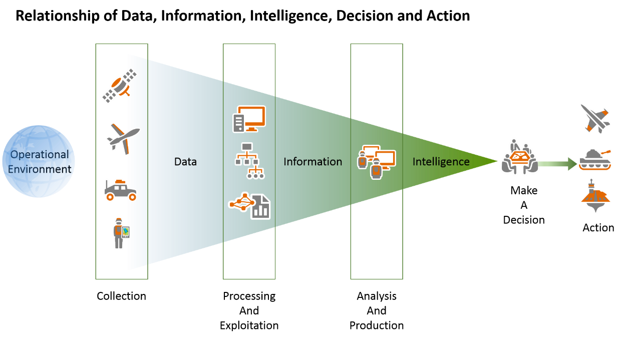
Intelligence can be distinguished from data and information in that intelligence provides reasoned insight into future conditions or situations.  GIS provides a common framework for turning data into decisions.


Capable of handling big data, ArcGIS allows decision-makers and analysts to access very large amounts of near real-time data and information relating to all aspects of the operational environment. Raw data can be plentiful, and information on its own may have minimal utility. But when integrated and considered with other information in the light of patterns and relationships, this new understanding of the information is what we call "intelligence."

The intelligence process incorporates a common workflow and terminology to facilitate the production of relevant intelligence products that support many missions. The process includes the following:

  • Requirements and planning
  • Collection
  • Processing and exploitation
  • Analysis and production
  • Dissemination and integration

At the 2018 Esri User Conference, we took a focused look at the management of intelligence processes.  Robert Feuerstein and I demonstrated the use of Esri web maps and apps that replace paper and email-based workflows and streamline the activities associated with Requests for Information (RFI) management, collection and asset management, data management, and production management.


These easy to use ArcGIS apps enable the following:

  • Field units, analysts, and operational planners can discover and access authoritative data and services from multiple databases and open sources. This content can be shared between units and organizations, at all levels of command. Keep in mind that handling instructions are a function of policy and still apply


  • Production Managers can use portal groups to prioritize and assign production tasks, while analysts leverage shared models and tools that streamline workflows and improve tradecraft


  • Use web forms and apps to manage requirements, data collection, and assets in real time. Field data collection units improve on paper-based workflows and directly contribute to intelligence production


  • Intelligence products and information can be shared with planners, decision-makers, and operators through dynamic briefings and story maps

Apps are revolutionizing how we communicate and share information across units and levels of command. If you missed our informative session, links to view the recording will be coming soon.

more
0 0 1,731
51 Subscribers
Labels