Defense and Intelligence Blog

cancel
Showing results for 
Show  only  | Search instead for 
Did you mean: 

Latest Activity

(22 Posts)
MatthewWoodlief
Esri Contributor

Esri geographic information system (GIS) technology supports the planning phase of the intelligence cycle with tools that help you understand data collection requirements for current and planned disposition of assets. ArcGIS provides a multi-intelligence environment for integrated collection across all five intelligence disciplines. GIS should be the hub of your intelligence cycle, no matter which "INT" you are interested in. To illustrate just some of the power of ArcGIS, we are going to look at Phase 1: Planning and Direction, as it specifically pertains to foundational geospatial intelligence (GEOINT).

Planning and direction are accomplished through these main responsibilities:
• Identifying intelligence requirements
• Prioritizing intelligence requirements
• Validating the requirements
• Translating requirements into measurables or collectibles
• Preparing collection plans
• Issuing requests for information (RFIs)
• Deciding on a dissemination medium

ArcGIS creates the ultimate advantage by giving you the power to answer the most difficult questions:
• How do I know where to start?
• How do I make sure that what I am collecting is timely and relevant?
• How can I help my team work collaboratively so efforts are not duplicated?
• How can I effectively disseminate the intelligence the team has gathered?

GIS as a System of Record

The use of GIS as a complete system of record allows you to answer these questions more efficiently:
• What datasets do I have?
• Where are they?
• How current are they?
Many agencies see GIS as an analysis or map production tool, and rightfully so. But I want you to start thinking of GIS as a system of record—a fully electronic and searchable system that allows you to quickly answer the questions above. The image below represents the data holdings at many agencies. There is a lot of data—scattered among disparate datasets—and it's hard, if not impossible, to get any real value from it.

The Strait of Hormuz with dots representing ships scattered around.

To illustrate this point further, I'd like to share an anecdote. My role as a data manager was to collect, organize, and deduplicate a client's data holdings. The client was a tech-savvy agency, so when I was told "it's all in shoeboxes," I assumed that meant, at worst, on a hard drive. I walked in the next morning to a big cardboard box brimming with shoeboxes of CDs, DVDs, and some hard drives! It turns out the saying was to be taken literally. This box was the agency's system of record.
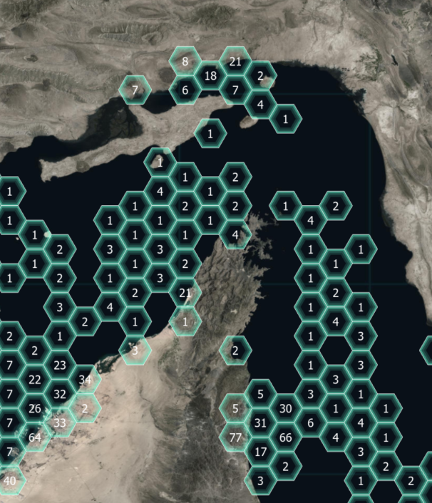
Our solution was to use ArcGIS as the system of record and organize the data holdings spatially. As each dataset was cataloged, it was stamped out according to the boundaries and fed into a database. The boundaries were also updated with attribution; so at the click of a button, we knew what we had, where it was, when it was collected, and how much we had. The illustration below uses hexbins as an abstraction of the concept of spatial cataloging. No matter what boundaries you choose to use, the result is quantifiable, searchable, and actionable information.

The Strait of Hormuz with hexbins representing counts of data holdings

It is much easier now to give direction to the planning stage, as our recommendations are backed by quantified data. Now that we have our system of record set up, let's see how that same system can be used as a planning tool.


GIS as a Collection Planning Tool
Leveraging your GIS gives you powerful capabilities:
• Query your data holdings
• Visualize your data
• Add metadata to clearly denote the currency and authoritative level of the data holdings
• Clearly define your area of interest (AOI)
How do these capabilities help us in this scenario? The planning cycle begins with understanding what you have. By using the querying abilities in your GIS, you can easily find where you have data and then place that data on the map so you know exactly how much coverage you have. The metadata associated with the data holdings is also searchable, so you can determine which areas have holdings that need a refresh. You can also integrate data from other sources, such as conflict data, to narrow and clearly define your area of interest. Your AOI is not just a hunch; it is backed by data and research. This can go a long way in securing funding for your operation and providing justification to your decision-makers.


Conclusion
In this post, we see how ArcGIS as a platform gives you the power to complete many of the phase 1 requirements—all within a single system. You can identify and prioritize your intelligence requirements by aggregating your disparate datasets and query the data to understand which is in the most need of updating. Validating these requirements through visualization techniques to see the holes in your datasets gives you a new perspective on the data holdings, and further justification on where to set collection efforts. You then translate these requirements into specific areas for collection and generation of collection plans based on real-world geographic boundaries. In a future post, we will see how this same system can be used to generate and respond to RFIs and become the dissemination system of choice.

more
3 1 2,399
RicklynHukriede
Esri Contributor

Modernizing National Government with GeoAI and ArcGIS


National government agencies are actively modernizing and automating their workflows to be more efficient and effective. GeoAI leverages artificial intelligence (AI) methods, natural language processing, process automation, staff augmentation, and data mining to extract key information from spatial big data. The use of GeoAI, together with geographic location information and analysis from ArcGIS to mine big data helps government agencies develop effective use of GeoAI and AIM strategies to get required knowledge quickly and with fewer resources.

Key Takeaways

See how to automate workflows using machine learning and computer vision in ArcGIS to quickly solve real-world problems. 

Attendees will learn how to

• Create deep learning training datasets with ArcGIS Pro. 
• Realize the power of the ArcGIS Pro Deep Learning toolset.
• Harness the object detection geoprocessing capabilities in ArcGIS Pro.
• Publish GeoAI geoprocessing services.

What: Modernizing National Government with GeoAI and ArcGIS
Date: Wednesday October 14, 2020
Time: 8:00 a.m. - 9:00 a.m. (PDT)
Where: Webinar Online Registration

more
0 0 422
RicklynHukriede
Esri Contributor

Deliver Analysis-Ready Data 

Government agencies are the authoritative source for creating and collecting data for public consumption.  By making data ready-to-use and more accessible improves how businesses plan their operations, regional governments support their constituents, and how developers build applications for consumers. Enable data consumers to access and incorporate authoritative data, thus giving more meaning to your work. ArcGIS has the capabilities to make data analysis-ready, accessible, and applicable to a variety of applications.  

Key Takeaways

Discover how you can produce and share analysis-ready data using ArcGIS resources like imagery products, ArcGIS Living Atlas of the World, Jupyter Notebook, ArcGIS Hub, and so much more.  Attendees will learn how to

• Incorporate location into their time-series analysis.
• Reduce cycle from data to apps.
• Support evidence-based decision-making.
• Improve your impact by delivering content to 7+ million professionals.

What: Deliver Analysis-Ready Data
Date: Thursday, August 27, 2020
Time: 10:00 a.m. - 11:00 a.m. (PDT)
Where: Webinar Online Registration

more
0 0 403
RicklynHukriede
Esri Contributor

Driving Operational Knowledge Through Drones

Drones are affordable and powerful data collection tools for governments worldwide.  There is now broad usage in surveying, disaster relief, search and rescue, surveillance, planning, scientific research, and so much more.  Now data collection and analysis from drones is faster than ever. Learn how Esri provides a cloud-based solution that maximizes the value of the data and minimizes the time from drone flight to decision making. 

Key Takeaways

Plan flights with GIS to gain the following:

  • Plan flights with GIS 

  •  Add image processing in your workflows 

  • Conduct analysis with ArcGIS deep learning tools with your drone data 

  • Improve understanding with enhanced data visualization and sharing capabilities 

 
What: Driving Operational Knowledge Through Drone
Date: Tuesday, May 19, 2020
Time: 10:00 a.m. - 11:00 a.m. (PDT)
Where: Webinar Online Registration

more
0 0 463
RicklynHukriede
Esri Contributor

Field Operations and Data Collection

ArcGIS is at the core of a smarter way to perform fieldwork. By leveraging location, users can perform their common tasks in a smarter way. Plan where you need to go, navigate to your assignment, understand your surroundings, and capture information, all while providing insight to allow real-time decision-making.

Key Takeaways

Learn how you can perform common field operations and data collection tasks in a more efficient and modern way.

This modern approach
• Works in a variety of technology systems.
• Allows you to pick the right tools for your workflow.
• Can be deployed immediately.

What: Field Operations and Data Collection
Date: Thursday, June 4, 2020
Time: 10:00 a.m. - 11:00 a.m. (PDT)
Where: Webinar Online Registration

more
0 0 668
by Anonymous User
Not applicable

Esri User Conference 2019 is just around the corner.  If you are a Federal Government Organization user and have questions about Esri Technical Support, we have you covered.  I will be providing a presentation with Malcolm Smith in our Expo Defense Area Theater focused on the the evolution of Technical Support for our Federal customers.  We will discuss Esri support programs and processes that provide improved technical support while maintaining customer data protections.  Speakers will be available to answer questions following the presentation. I hope we see you there.

more
2 0 552
by Anonymous User
Not applicable

Defense and Intelligence users, are you looking for technical support resources at Esri Federal GIS Conference?  You will find Analysts and Technical Account Managers at the "Implementing ArcGIS" Area in the Expo.  In this area you will also discover tips and techniques that help you implement ArcGIS to achieve mission success.  Area topics include:

  • Strategy & Planning
  • Architecture & Security
  • GeoData Engineering
  • Configuration & Integration
  • Workforce Development
  • Operational Support

more
2 0 621
by Anonymous User
Not applicable

Are you coming to Esri's Federal GIS Conference?  Dont forget the visit the Defense and Intelligence Areas in the Expo area.  Here you can meet with Esri Defense and Intelligence staff to discuss your mission needs, learn about real-world use of ArcGIS, and discover new capabilities.  Highlights include:

  • Smart Installations for operational readiness
  • Geo-enabled mission apps for Command and Control
  • Military Tools for ArcGIS
  • Connecting Intelligence and Operations to enhance intelligence tradecraft
  • ArcGIS Pro Intelligence Workstation

more
0 0 559
KarlTerrey
New Contributor III

Did you know that Military Tools for ArcGIS just released version 3.1?  

Military Tools for ArcGIS is a collection of add-ins and geoprocessing toolboxes for ArcGIS. They are fundamental tools for coordinate conversion, distance and direction calculations, visibility analysis, creating rectangular grids, and the creation of military symbols.


Use Military Tools for ArcGIS to do the following:

  • Input coordinates and quickly convert them between several standard formats.
  • Dynamically create geodetic lines, circles, ellipses, and range rings.
  • Conduct interactive linear and radial line-of-sight analysis.
  • Quickly create standard military symbols (MIL-STD-2525D and MIL-STD-2525B w/CHANGE 2 )in ArcGIS Pro.
  • Quickly create rectangular grids from areas or points, and number the features, using the Military Tools toolbox.


Military Tools for ArcGIS 3.1 supports the following products:

  • ArcMap™ 10.3.1, to 10.6.1
  • ArcGIS Pro 2.1 and 2.2
  • Web AppBuilder for ArcGIS Developer Edition 2.4 to 2.9


To download Military Tools for ArcGIS, visit http://solutions.arcgis.com/defense/help/military-tools/

Complete the Learn ArcGIS lesson using Military Tools for ArcGIS.

View the Military Tools for ArcGIS webinar.

more
1 0 1,001
KarlTerrey
New Contributor III

Back in June we wrote about the development of the Intelligence Configuration for ArcGIS Pro (ICAP), and now it is time to announce the release of ICAP 1.0.

ICAP is a managed configuration of ArcGIS, which includes add-ins, geoprocessing tools, and project templates. This ArcGIS Pro configuration is built specifically for intelligence analysts. These combined components provide a streamlined user experience and specialized tools to aid intelligence analysts in their workflows. ICAP is available to Esri customers at no additional cost.  Some of the new capabilities  included in ICAP:

  • Link charts—Intelligence Configuration for ArcGIS Pro provides the ability to visualize entities and their relationships. This capability allows analysts to easily see, edit, and manipulate link diagrams of people, groups, and events that would otherwise be viewed in a table or on a map. In one single interface, analysts can see the complex relationships between different assets, with minimal data and little or no learning curve. The link chart is created dynamically based on the source data, which can be manipulated via the chart, map, or attribute table.
  • Conditions and alerts—To ease the burden of filtering and querying data to discover its value, ICAP provides a way for analysts to designate conditions based on a set of queries and then be alerted when these conditions are met. For instance, when a mortar activity is within 7 kilometers of a reported location, an alert notifies the analyst, and the activity is logged for further analysis.
  • Data management—ArcGIS Pro already has many robust data management tools and workflows. To better support intelligence analysts, ICAP will bring the most commonly used data management tools to the forefront, placing widely used tools in a custom data management ribbon. In addition, ICAP introduces a tool that grabs files commonly used by the intelligence analyst (such as .shp, .kml, .kmz, .xls(x), and .csv) and adds them to the map with the right symbology, including standard 2525 military symbology.


For more information, and to download ICAP, visit: http://go.esri.com/icap

You may also want to view a webinar we did: https://www.youtube.com/watch?v=68uh3h3YJsE&feature=youtu.be

more
2 0 1,530
51 Subscribers
Labels