- Home
- :
- All Communities
- :
- Products
- :
- Data Management
- :
- Data Management Questions
- :
- Unknown Spatial Reference
- Subscribe to RSS Feed
- Mark Topic as New
- Mark Topic as Read
- Float this Topic for Current User
- Bookmark
- Subscribe
- Mute
- Printer Friendly Page
Unknown Spatial Reference
- Mark as New
- Bookmark
- Subscribe
- Mute
- Subscribe to RSS Feed
- Permalink
Anyone know what coordinate system this is in. Trying to display it on arcmap and its showing up in the gulf of guinea. It is supposed to show up in Edmonton Canada. I used add x and y then tried define projection. But because its projection is unknown. I am not able to project it to NAD 83 UTM 114. I have gone through different projections trying to guess the right one but i have not been successful. Any one Know how i can fix this? Thanks
- Mark as New
- Bookmark
- Subscribe
- Mute
- Subscribe to RSS Feed
- Permalink
Edmonton
Longitude -113.4909 aka 'X'
Latitude 53.5444 aka 'Y'
Gulf of Guinea
Latitude 3.7355
Longitude 3.7435
Can we safely rule out a simple coordinate switch? which is fairly common... Longitude is 'X', Latitude is 'Y'
Can we rule out -ve sign missing in the longitudes.
So given the non-similar difference, the only thing in common is that your coordinates seem to be missing 110 in the 'X' and 50 in the 'Y'
Perhaps a couple of rows will help and Can you state what coordinates they were supposed to be in? Since a Geographic Coordinate system doesn't seem plausible and a UTM would put you near the equator even with a UTM zone
- Mark as New
- Bookmark
- Subscribe
- Mute
- Subscribe to RSS Feed
- Permalink
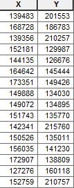
Thanks Dan for your reply. This data is supposed to be in NAD 83 UTM 114, A custom one that we use. That is the projection of choice.The data came in a spreadsheet and is supposed to be from mapnet software. I dont know the spatial reference that was used when it was collected. I switched the x and y values and it showed up in the Pacific ocean. I am trying to derive the longitudes and latitudes from these x and y values. I have attached more rows. I am at a loss what to do next. I have tried changing the projections of the data frame to see where it shows up but never in the right place.
- Mark as New
- Bookmark
- Subscribe
- Mute
- Subscribe to RSS Feed
- Permalink
Mapnet? never heard of it... it doesn't even look like a web Mercator (check though, stranger things have happened)
It can't even be in UTM since either value isn't large enough to be a representative value from the equator. Given that in a standard UTM zone, 45 degrees latitude is about-ish 5,000,000 metres from the equator.
It looks like your coordinate system might be something different ... is there a chance that you use Lambert conformal conics of some kind? any projection being used by Edmonton that may not have a standard parallel of the equator.
Best solution! Find the person that gave you the spreadsheet and ask them
- Mark as New
- Bookmark
- Subscribe
- Mute
- Subscribe to RSS Feed
- Permalink
Thanks Dan
I will have to ask. The x and y values are not making any sense. Seems like something is missing. I appreciate your input.
- Mark as New
- Bookmark
- Subscribe
- Mute
- Subscribe to RSS Feed
- Permalink
keep us posted... gave up Dr Google, all I could come up with is some school bus routing software or a masters program in photonics engineering... both sound cool but probably off-track