Turn on suggestions
Auto-suggest helps you quickly narrow down your search results by suggesting possible matches as you type.
Cancel
- Home
- :
- All Communities
- :
- Products
- :
- Data Management
- :
- Data Management Questions
- :
- SDO_GEOMETRY and datum transformations
Options
- Subscribe to RSS Feed
- Mark Topic as New
- Mark Topic as Read
- Float this Topic for Current User
- Bookmark
- Subscribe
- Mute
- Printer Friendly Page
04-04-2013
03:24 PM
- Mark as New
- Bookmark
- Subscribe
- Mute
- Subscribe to RSS Feed
- Permalink
Hello all,
We have a 10.0 SDE instance, with Oracle 11.1.0.7 as the underlying dbms. Our data is stored in Oracle's SDO_Geometry format, with an Oracle SRID of 4326 (WGS84 Geographic). Everything works fine, performance is good, but we have a problem with datum transformations.
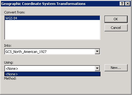
Our users frequently want to view and map the data in one or more UTM zones, using Nad27 as their datum. ArcMap will project the data with no problem, but it does not populate the datum transformations list:
[ATTACH=CONFIG]23221[/ATTACH]
Two solutions I've considered:
1. Manually define the transformation. This is no problem, but is there any way to persist this? I don't think we could rely on our users to do this correctly and consistently.
2. Create a custom SDO datum, using the ESRI datum name. To the best of my knowledge, the definitions for both versions of the WGS84 datums are the same, but they have different names(the ESRI version is called "GCS_WGS_1984", while Oracle's version is "WGS 84"). I had considered entering a custom datum into the Oracle SDO_DATUMS table, with the same definition, but using the ESRI name, to try and "trick" ArcMap into using the same transforms. I have no idea if this would work, though.
I'm not sure how to proceed here, but I feel like both of these solutions are convoluted, and I must be missing something obvious.
Has anyone dealt with this issue?
We have a 10.0 SDE instance, with Oracle 11.1.0.7 as the underlying dbms. Our data is stored in Oracle's SDO_Geometry format, with an Oracle SRID of 4326 (WGS84 Geographic). Everything works fine, performance is good, but we have a problem with datum transformations.
Our users frequently want to view and map the data in one or more UTM zones, using Nad27 as their datum. ArcMap will project the data with no problem, but it does not populate the datum transformations list:
[ATTACH=CONFIG]23221[/ATTACH]
Two solutions I've considered:
1. Manually define the transformation. This is no problem, but is there any way to persist this? I don't think we could rely on our users to do this correctly and consistently.
2. Create a custom SDO datum, using the ESRI datum name. To the best of my knowledge, the definitions for both versions of the WGS84 datums are the same, but they have different names(the ESRI version is called "GCS_WGS_1984", while Oracle's version is "WGS 84"). I had considered entering a custom datum into the Oracle SDO_DATUMS table, with the same definition, but using the ESRI name, to try and "trick" ArcMap into using the same transforms. I have no idea if this would work, though.
I'm not sure how to proceed here, but I feel like both of these solutions are convoluted, and I must be missing something obvious.
Has anyone dealt with this issue?
Solved! Go to Solution.
1 Solution
Accepted Solutions
04-08-2013
05:45 PM
- Mark as New
- Bookmark
- Subscribe
- Mute
- Subscribe to RSS Feed
- Permalink
Just in case anyone else has the same issue, the second approach worked well. I added new entries to SDO_DATUMS and SDO_COORD_REF_SYSTEM using the custom datum named 'GCS_WGS_1984', and the datum transforms now work properly in ArcMap.
1 Reply
04-08-2013
05:45 PM
- Mark as New
- Bookmark
- Subscribe
- Mute
- Subscribe to RSS Feed
- Permalink
Just in case anyone else has the same issue, the second approach worked well. I added new entries to SDO_DATUMS and SDO_COORD_REF_SYSTEM using the custom datum named 'GCS_WGS_1984', and the datum transforms now work properly in ArcMap.