Turn on suggestions
Auto-suggest helps you quickly narrow down your search results by suggesting possible matches as you type.
Cancel
- Home
- :
- All Communities
- :
- Products
- :
- Data Management
- :
- Data Management Questions
- :
- Re: Rookie - how to get continious polylines expo...
Options
- Subscribe to RSS Feed
- Mark Topic as New
- Mark Topic as Read
- Float this Topic for Current User
- Bookmark
- Subscribe
- Mute
- Printer Friendly Page
Rookie - how to get continious polylines exporting contours to DWG
Subscribe
815
5
02-02-2013 11:35 AM
by
Anonymous User
Not applicable
02-02-2013
11:35 AM
- Mark as New
- Bookmark
- Subscribe
- Mute
- Subscribe to RSS Feed
- Permalink
- Report Inappropriate Content
Original User: offwhite
I am a green newby working my way through generating contours from LiDAR images to export contour lines into my architectural software, [ArchiCAD], in DWG format to generate better site plans for my design work. I am all of the way there with a single glitch........
When the DWG is placed/imported into my program what should, [as in I want to be], be continious polylines some up as a bi-gillion single little lines, creating arcs andcurves by splitting them into thousands of little elements.
I presume this is pilot error and with some guidance, [thank you in advance!], on how to adjust my settings this can be overcome. Any help will be greatly appreciated!
5 Replies
02-04-2013
05:10 AM
- Mark as New
- Bookmark
- Subscribe
- Mute
- Subscribe to RSS Feed
- Permalink
- Report Inappropriate Content
some tidbit, someone....?
by
Anonymous User
Not applicable
02-07-2013
08:37 AM
- Mark as New
- Bookmark
- Subscribe
- Mute
- Subscribe to RSS Feed
- Permalink
- Report Inappropriate Content
Original User: khodge
I'll give it a shot...but I'll probably create more questions than answers.
The geoprocessing tool ExportToCad will create true curves with elevations from GIS features to DWG. So it is possible. But....
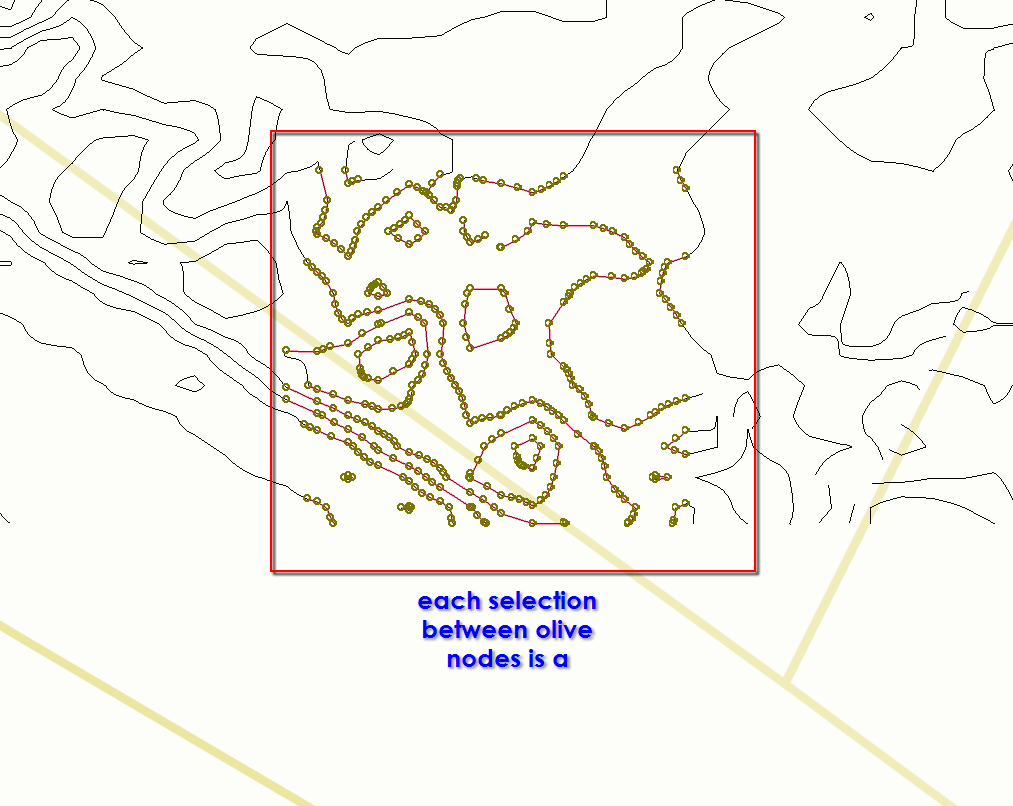
It can only create curves if you start with curves. In your case, it appears that your GIS features are in a shp file. Shp doesn't support curved features, it approximates curves using short line segments--which is what you are seeing.
If you can't bypass the use of a shape file, you need to find a way to create curved features from your data. You may be able to do this in ArchiCAD by spline fitting the vertices, but you could lose some accuracy. You may also be able to do this in ArcMap--I'd ask the Geoprocessing gurus how to create curves from line segments.
Hope this helps.
--Karen
some tidbit, someone....?
I'll give it a shot...but I'll probably create more questions than answers.
The geoprocessing tool ExportToCad will create true curves with elevations from GIS features to DWG. So it is possible. But....
It can only create curves if you start with curves. In your case, it appears that your GIS features are in a shp file. Shp doesn't support curved features, it approximates curves using short line segments--which is what you are seeing.
If you can't bypass the use of a shape file, you need to find a way to create curved features from your data. You may be able to do this in ArchiCAD by spline fitting the vertices, but you could lose some accuracy. You may also be able to do this in ArcMap--I'd ask the Geoprocessing gurus how to create curves from line segments.
Hope this helps.
--Karen
02-15-2013
06:16 AM
- Mark as New
- Bookmark
- Subscribe
- Mute
- Subscribe to RSS Feed
- Permalink
- Report Inappropriate Content
Hi
There is an optional extension to the FME product - CurveFitter - which might do the job.
Sorry the function is not included in Data Interpoerability.
Regards
There is an optional extension to the FME product - CurveFitter - which might do the job.
Sorry the function is not included in Data Interpoerability.
Regards
by
Anonymous User
Not applicable
02-15-2013
07:41 AM
- Mark as New
- Bookmark
- Subscribe
- Mute
- Subscribe to RSS Feed
- Permalink
- Report Inappropriate Content
Original User: khodge
Thanks, Bruce.
Also...AutoCAD can smooth the plines, but I find it doesn't do as thorough a job as I'd like.
Thanks, Bruce.
Also...AutoCAD can smooth the plines, but I find it doesn't do as thorough a job as I'd like.
02-15-2013
11:20 AM
- Mark as New
- Bookmark
- Subscribe
- Mute
- Subscribe to RSS Feed
- Permalink
- Report Inappropriate Content
thanks Bruce & Karen.........I'll continue with work-arounds.