Turn on suggestions
Auto-suggest helps you quickly narrow down your search results by suggesting possible matches as you type.
Cancel
- Home
- :
- All Communities
- :
- Products
- :
- Data Management
- :
- Data Management Questions
- :
- [Question] Setting up Types and SubTypes
Options
- Subscribe to RSS Feed
- Mark Topic as New
- Mark Topic as Read
- Float this Topic for Current User
- Bookmark
- Subscribe
- Mute
- Printer Friendly Page
[Question] Setting up Types and SubTypes
Subscribe
2744
1
06-04-2014 08:34 AM
06-04-2014
08:34 AM
- Mark as New
- Bookmark
- Subscribe
- Mute
- Subscribe to RSS Feed
- Permalink
Hi guys, first post here, I hope to get it in the right part of the forum.
I've been using ArcGIS software for some time, throught out college and now at work.
I have a doubt here.
I was given a task to make a .gdb where we'd join/merge several diferent datalayers, they're all points, from diferente types/categories of information, and we want them to be in one single layer inside that .gdb, so when we open it we have all the information, and the possibility to choose one type or another in a fast way.
We thought about Domains / Types / Subtypes, but there's a problem, I'll try to exemplify (my english isn't the best, sorry for that)
considering two fields, Field 1 will be the 'groups' and Field 2 will be the 'subgroups', I've managed to set up the 'groups' in arcgis catalog, and confirmed it in arcgis desktop, but I wanted the 'subgroups' to be dependant on the first field - 'groups'
in other words...when editing in desktop, after i set field 1/groups, i want field 2/subgroups to give me the options/categories related to it's respective field 1/group.
Categories as example:
Field 1 / Groups
Urban
Rural
Water
Field 2 / SubGroups
Industrial (urban)
Residential (urban)
Forest (rural)
Farm (rural)
Ocean (water)
River (water)
Hope i was clear on it...if you need anything, just ask, and if you can help, help 😛
ArcGIS Version - 9.3
TY, cheers
1 Reply
06-09-2014
03:08 PM
- Mark as New
- Bookmark
- Subscribe
- Mute
- Subscribe to RSS Feed
- Permalink
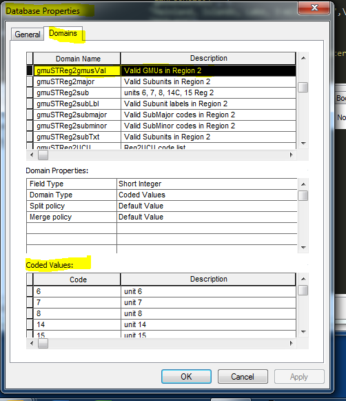
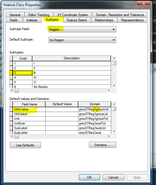
Hi, am am using 10.2.x and I know this worked as far back as 10.0, but I don't have access to 9.3 right now so I can not test. I have what I think is a similar structure. That is, I have five regions as a short integer (1-5 plus 9 for "no region") that I use as for my Subtype field.
I then have a series of domain tables that I have broken down to the values needed for each region, for a particular field (graphic #3). In the Subtype Field tab of the feature class properties, I select one of the Subtype codes. I can then select a field in the table below and assign a custom domain to the field for the associated region. (two samples, graphic 1 and 2).
Since I reassign these to my FGDB version about once a month, and have about 75 different domains (with most divided by region) I have this setup in a arcpy script. I'm not sure that my script, as is, would do you much good since it is pretty long and specific to my needs, but if you are really comfortable with arcpy, I can maybe explain the important parts (and parts may not work in 9.3)
Since you are on 9.3., first thing I would check is whether the Subtype tab has the same options. Sorry to waste your time if it doesn't, but this might help someone else in future.
Good luck,
-becky