- Home
- :
- All Communities
- :
- Products
- :
- Data Management
- :
- Data Management Questions
- :
- Point Features not fully displaying
- Subscribe to RSS Feed
- Mark Topic as New
- Mark Topic as Read
- Float this Topic for Current User
- Bookmark
- Subscribe
- Mute
- Printer Friendly Page
- Mark as New
- Bookmark
- Subscribe
- Mute
- Subscribe to RSS Feed
- Permalink
Hello,
I have a point feature class that was created by geocoding a bunch of addresses out of an excel table. When these points are added to my map, it appears that only a small portion of them are displaying. I cannot determine why this is happening.
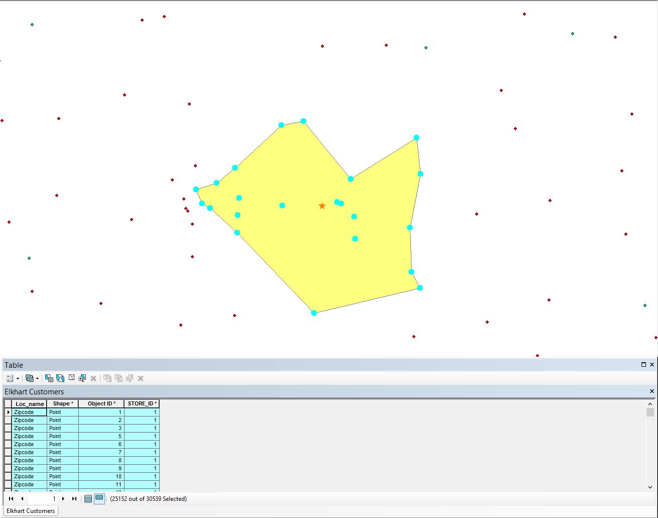
The point feature class contains 30,539 points. I have selected a subset of around 25,152 of those 30k points. Yet on my map it is only showing around 20 point as being part of that selection. For some reason ArcMap is not displaying all of the points.
I am wondering if there is some sort of setting turned on that is filtering out the display of all points in order to optimize display rendering or something along these lines? I have attempted to export this FC as a new FC and get the same result.
Attached is a screenshot. Notice at the bottom where it says 25152 out of 30539 selected, yet in the map view I am only seeing about 15-20 points...(I had to hide some fields in my attribute table)
Your contributions are greatly appreciated. Hopefully this is an easy one to solve for you experts out there.
Solved! Go to Solution.
Accepted Solutions
- Mark as New
- Bookmark
- Subscribe
- Mute
- Subscribe to RSS Feed
- Permalink
Are those points outside the polygon from the same feature class? Should the polygon be filled with 25,000+ points? Have you confirmed that the 25,000 selected points aren't and shouldn't be coincident?
- Mark as New
- Bookmark
- Subscribe
- Mute
- Subscribe to RSS Feed
- Permalink
Are those points outside the polygon from the same feature class? Should the polygon be filled with 25,000+ points? Have you confirmed that the 25,000 selected points aren't and shouldn't be coincident?
- Mark as New
- Bookmark
- Subscribe
- Mute
- Subscribe to RSS Feed
- Permalink
You can confirm whethere you have duplicates in a variety of ways... calculate the X,Y values in the table, then sort by the x field (use full decimal display), if a bunch are the same, then you may have an issue with the number of decimals represented by the coordinates you imported. I have seen cases where longitude and latitude got truncated to 4 decimal places... which is pretty bad for most place. PS, what it looks like in excel has no bearing on what it actual it and what arrives in Arc*
- Mark as New
- Bookmark
- Subscribe
- Mute
- Subscribe to RSS Feed
- Permalink
@Darren, @Dan
You both nailed it. I checked and the points are all overlapping/coincident. Apparently the geocode didnt properly code the addresses and coded them by zipcode (at the zipcode centroid). Never even occurred to me, but thankfully it did occur to you. Guess I should have checked this.
Cheers