- Home
- :
- All Communities
- :
- Products
- :
- Data Management
- :
- Data Management Questions
- :
- Re: Please help, Wrong Projection??
- Subscribe to RSS Feed
- Mark Topic as New
- Mark Topic as Read
- Float this Topic for Current User
- Bookmark
- Subscribe
- Mute
- Printer Friendly Page
- Mark as New
- Bookmark
- Subscribe
- Mute
- Subscribe to RSS Feed
- Permalink
Dear all,
First of all I am new to ArcGis 
I was given a shapefile with the information of the bathymetry of a Portuguese river reach. In the same shapefile "package" there was one file with the information of the projection, a *.prj file.
I have loaded the shapefile on ArcGis and I got this information:
Projected Coordinate System: Lisbon_Lisbon_Portuguese_Grid Projection: Transverse_Mercator false_easting: 0,00000000 false_northing: 0,00000000 central_meridian: 1,00000000 scale_factor: 1,00000000 latitude_of_origin: 39,66666667 Linear Unit: Meter
Geographic Coordinate System: GCS_Lisbon (Lisbon) Datum: D_Lisbon Prime Meridian: Lisbon Angular Unit: Degree
This should be correct, but I used "layer to KML" and checked the location of this river in Google Earth, and it was placed on the sea, near Ibiza island. And this is a Portuguese river reach...
So, something is not correct here and I really do not know what can I do to project this river in the correct place... Can someone help me?
I know exactly the location of the river reach on Google Earth!
Thanks!
Solved! Go to Solution.
Accepted Solutions
- Mark as New
- Bookmark
- Subscribe
- Mute
- Subscribe to RSS Feed
- Permalink
see if you can project the file to a geographic coordinate system first (aka a GCS WGS 84 or something standard). It may be the projected to projected coordinate system that is the issue. So in summary, project to decimal degrees, then project from decimal degrees to that webbie projection
- Mark as New
- Bookmark
- Subscribe
- Mute
- Subscribe to RSS Feed
- Permalink
You will have to project your data to a WGS 1984 Web Mercator (Auxiliary Sphere) coordinate system... for example
Not lining up with Google Earth even after changing the projection
- Mark as New
- Bookmark
- Subscribe
- Mute
- Subscribe to RSS Feed
- Permalink
But be careful.
Portugal seems to have a rather complex history regarding geodetic control.
Several different versions listed in the documentation and in the EPSG database.
Including the very confusingly named :
Lisbon_1890_Lisbon_To_Lisbon
Might be useful to do a bit of research here on exactly what you are dealing with.
- Mark as New
- Bookmark
- Subscribe
- Mute
- Subscribe to RSS Feed
- Permalink
I have to truly thank you both for trying to help me!
I have researched on the EPSG database and I think I am dealing with EPSG:20790.
I have tried to to that transformation between datums and I always get a error after ArcGis process the "Project" feature...
Maybe I am choosing the wrong type of transformation? I have already tried a lot of them...
I will post here the data that I am working, can someone have a look on it please? I'm really lost!
Thanks again!!
- Mark as New
- Bookmark
- Subscribe
- Mute
- Subscribe to RSS Feed
- Permalink
You of course, used the Define Projection tool first if the file didn't have a defined coordinate system. Then you can proceed to the Project tool. If it had a defined projection... that you can confirm in the layer's properties, you can skip the Define step.
- Mark as New
- Bookmark
- Subscribe
- Mute
- Subscribe to RSS Feed
- Permalink
Dear Dan,
I did not used "Define Projection" tool. The data that was given to me already had the information regarding the coordinate system.
I'm trying to do use the "Project" tool to project this data in the WGS 84 like you have said. But I can't, I always get an error. I will screenshot what I am doing.
Here I select this Geographic Transformation (the only one in this list).

After press "OK" I get this error:

I really do not know how to solve this...
Thanks!
- Mark as New
- Bookmark
- Subscribe
- Mute
- Subscribe to RSS Feed
- Permalink
a screen grab of the properties of the layer would be useful... just to confirm what the extent of the file is, its type and to see if the defined coordinate system matches. Also... never save a file to the root directory of drive...just not good practice in some environments
- Mark as New
- Bookmark
- Subscribe
- Mute
- Subscribe to RSS Feed
- Permalink
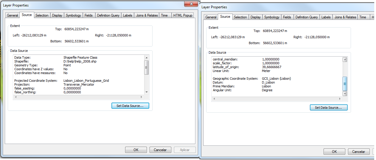
Dear Dan, here I attach a screen grab of the properties of the layer:
Regarding the file, I am just saving this on the root of the drive just for testing purposes! My work is on other folders that I do not want to "contaminate" with testing purposes
Thanks for the help!!
- Mark as New
- Bookmark
- Subscribe
- Mute
- Subscribe to RSS Feed
- Permalink
see if you can project the file to a geographic coordinate system first (aka a GCS WGS 84 or something standard). It may be the projected to projected coordinate system that is the issue. So in summary, project to decimal degrees, then project from decimal degrees to that webbie projection