- Home
- :
- All Communities
- :
- Products
- :
- Data Management
- :
- Data Management Questions
- :
- Opening a shp file: One or more layers failed to d...
- Subscribe to RSS Feed
- Mark Topic as New
- Mark Topic as Read
- Float this Topic for Current User
- Bookmark
- Subscribe
- Mute
- Printer Friendly Page
Opening a shp file: One or more layers failed to draw. There was a problem drawing the shapefile. Drawing aborted
- Mark as New
- Bookmark
- Subscribe
- Mute
- Subscribe to RSS Feed
- Permalink
Hi all,
I'm new to ArcMap, and trying to open up a shp file created by someone else (uploaded on a public domain) on railroads in the US. However, I've been encountering the following error:
"One or more layers failed to draw:
(layer name): There was a problem drawing the shapefile. Drawing aborted."
Although the map still shows up, I cannot use it for any further analysis. I have tried re-downloading the file, used different computers, and following some recommendations found online, repairing the geometry and Shape Checker by A. Williamson. The first ran successfully, but did not solve the error. The second detected too many records in dbf file and deleted 29 trailing records, but did not solve the problem either.
I would greatly appreciate any advice on how to solve this issue. Thanks in advance!
Solved! Go to Solution.
Accepted Solutions
- Mark as New
- Bookmark
- Subscribe
- Mute
- Subscribe to RSS Feed
- Permalink
No problem - the easiest way to do it would be like so:
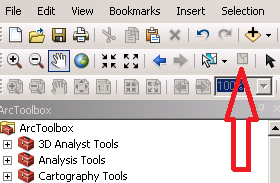
1) Within ArcMap, make sure you have no records selected by choosing the "clear features" option in the top menu bar (just to make sure none are selected - it'll be greyed-out if none are selected):
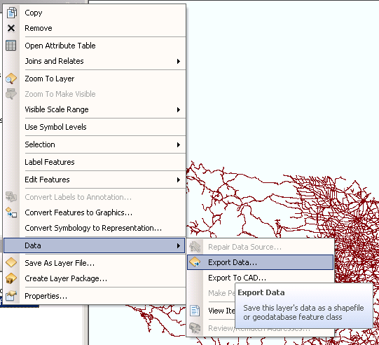
2) Next, right click on the layer in the TOC and choose "export data" under the "Data" option:
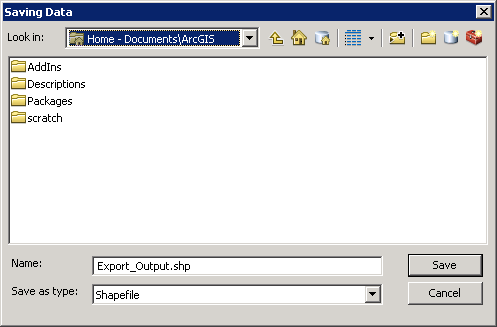
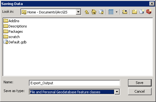
3) In the "Export Data" window, navigate to your default geodatabase, which should be in "Home - Documents\ArcGIS"
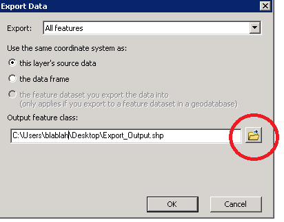
4) In the "Save as type" drop-down, choose "File and Personal Geodatabase feature classes" (this will expose the scratch geodatabase):
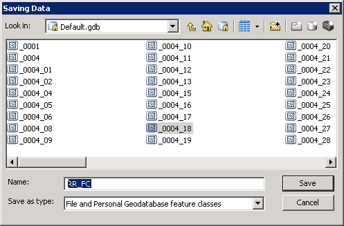
5) Double-click Default.gdb
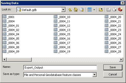
6) Once you are inside the gdb, name it whatever you'd like (though there are some limitations... just keep it short and without any special chars, and don't start it with a number) - in this case, I named it "RR_FC"
7) Click "Save"
😎 Click "OK"
9) Click "Yes" when ArcMap asks you "Do you want to add the exported data to the map as a layer?"
10) Right click on the layer "RR_FC" (or whatever you named it)
11) Repeat steps 2 and 3 above
12) Change the drop-down back to "shapefile" and name it something unique:
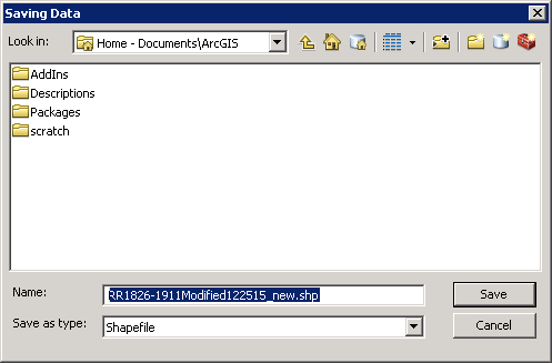
13) Repeat steps 7-9 above
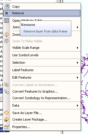
14) Remove all of the other layers from the map (the bad shapefile and the feature class). You can do this by right-clicking the layer and selecting "Remove":
15) Once all of the layers are removed, close the "ArcMap Drawing Errors" window
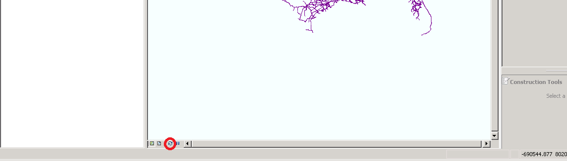
16) Next, click the refresh icon at the bottom of the data pane:
You should no longer see the drawing error.
- Mark as New
- Bookmark
- Subscribe
- Mute
- Subscribe to RSS Feed
- Permalink
Hi Cindy,
Can you upload the shapefile here? Or point to where you obtained it from?
- Mark as New
- Bookmark
- Subscribe
- Mute
- Subscribe to RSS Feed
- Permalink
Hi Adrian,
Many thanks for the reply! The shp file I'm trying to open can be downloaded here:
https://my.vanderbilt.edu/jeremyatack/data-downloads/
In the zip file named: ""Railroads, 1826-1911"
Thank you very much for your help!
- Mark as New
- Bookmark
- Subscribe
- Mute
- Subscribe to RSS Feed
- Permalink
Cindy,
I tried the check and repair geometry tools in ArcToolbox to no avail. Exporting to a feature geodatabase then back to a shapefile resolved the issue for me.
- Mark as New
- Bookmark
- Subscribe
- Mute
- Subscribe to RSS Feed
- Permalink
Hi Chris,
Many thanks for the reply, and for finding a solution to this! I apologise, but as I'm still pretty new to ArcMap, I'm not very sure what you meant by exporting the shp file to a feature geodatabase. Would it be possible for you to provide more details on how you resolved this issue?
Thank you very much!
- Mark as New
- Bookmark
- Subscribe
- Mute
- Subscribe to RSS Feed
- Permalink
No problem - the easiest way to do it would be like so:
1) Within ArcMap, make sure you have no records selected by choosing the "clear features" option in the top menu bar (just to make sure none are selected - it'll be greyed-out if none are selected):
2) Next, right click on the layer in the TOC and choose "export data" under the "Data" option:
3) In the "Export Data" window, navigate to your default geodatabase, which should be in "Home - Documents\ArcGIS"
4) In the "Save as type" drop-down, choose "File and Personal Geodatabase feature classes" (this will expose the scratch geodatabase):
5) Double-click Default.gdb
6) Once you are inside the gdb, name it whatever you'd like (though there are some limitations... just keep it short and without any special chars, and don't start it with a number) - in this case, I named it "RR_FC"
7) Click "Save"
😎 Click "OK"
9) Click "Yes" when ArcMap asks you "Do you want to add the exported data to the map as a layer?"
10) Right click on the layer "RR_FC" (or whatever you named it)
11) Repeat steps 2 and 3 above
12) Change the drop-down back to "shapefile" and name it something unique:
13) Repeat steps 7-9 above
14) Remove all of the other layers from the map (the bad shapefile and the feature class). You can do this by right-clicking the layer and selecting "Remove":
15) Once all of the layers are removed, close the "ArcMap Drawing Errors" window
16) Next, click the refresh icon at the bottom of the data pane:
You should no longer see the drawing error.
- Mark as New
- Bookmark
- Subscribe
- Mute
- Subscribe to RSS Feed
- Permalink
Hi Chris!
Wow, thank you very much for the detailed information and help! It worked perfectly!
Thank you so much for all the time and effort!