- Home
- :
- All Communities
- :
- Products
- :
- Data Management
- :
- Data Management Questions
- :
- needing a little help with a gdb and a standalone ...
- Subscribe to RSS Feed
- Mark Topic as New
- Mark Topic as Read
- Float this Topic for Current User
- Bookmark
- Subscribe
- Mute
- Printer Friendly Page
needing a little help with a gdb and a standalone table
- Mark as New
- Bookmark
- Subscribe
- Mute
- Subscribe to RSS Feed
- Permalink
I was given a gdb from a client containing a water system (lines, valves, meters, etc). Not a large one. I subsequently asked if there was any elevation data obtained when the data was field surveyed. He then sent me a standalone table titled "gpsPositions" Could have have someone look at these and tell me how to "join" them? Any help would be greatly appreciated.
MKH
Solved! Go to Solution.
Accepted Solutions
- Mark as New
- Bookmark
- Subscribe
- Mute
- Subscribe to RSS Feed
- Permalink
For the point featureclasses you can use the Spatial Join to join the elevation from the closest GPS point to the features. There are a lot of GPS points around the features, but the spatial join will only pass the data of the nearest feature. In this case I didn't much variation in the elevation, so that will probably not be an issue.
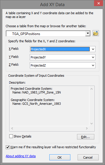
Add the table to the TOC, right click on the table and select Display XY data:
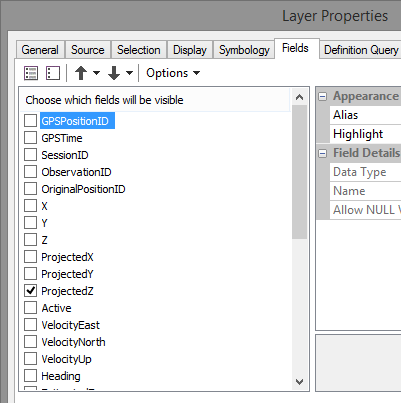
For the feature layer that is added enter the properties, activate the Fields tab and switch off all the fields that aren't relevant (this will avoid them to be joined to your features):
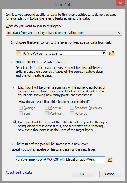
Just leave the one with the elevation switched on (I assume it is ProjectedZ). Next right click on the featureclasses you want to enrich with the elevation, and select Join and Relates..., and Join. Select Join data from another layer based on spatial location, select the XY events (GPS data), select each point will be given all the attributes..., specify the output and click OK.
A new featureclass will be created with the elevation added and a field with the distance between the features and the GPS point from which the elevation was joined.
For points this is easy, for lines you cannot do this. The GPS points are also to sparse to interpolate the elevation and create a surface (TIN). Although you could try and use that to convert the lines into 3D lines. Another possibility would be to interpolate the elevations between nodes with a GPS point close, but that would require some programming.
- Mark as New
- Bookmark
- Subscribe
- Mute
- Subscribe to RSS Feed
- Permalink
Were you meaning to have someone on the forum take a look at your data? If so it didn't make the post.
If they did it right, there should be a common id between the two. If not, you're going to have to figure it out on your own.
- Mark as New
- Bookmark
- Subscribe
- Mute
- Subscribe to RSS Feed
- Permalink
would add the data, but can't find the place to add an attachment
- Mark as New
- Bookmark
- Subscribe
- Mute
- Subscribe to RSS Feed
- Permalink
You might try creating a feature class of the gps points using add xy data. Then you could make an assessment as to which gps data is associated with the each of the features. Or you could add two new columns in your point data and use the geometry calculator to add in the value for x,y and compare them.
I'm kind of scratching my head though as to why you need the gps data at all; you already have points...
- Mark as New
- Bookmark
- Subscribe
- Mute
- Subscribe to RSS Feed
- Permalink
don't need x, and y....because as you mentioned I already have locations. We need elevation data to model the water system. SOftware uses elev to determine needed pressures, etc.
- Mark as New
- Bookmark
- Subscribe
- Mute
- Subscribe to RSS Feed
- Permalink
being new at this....do you see any way I can join the gdb to have the elevations?
- Mark as New
- Bookmark
- Subscribe
- Mute
- Subscribe to RSS Feed
- Permalink
As mentioned, add the gps data as an xy event layer and save it to a feature class. You could then perform a spatial join between your new set of points and each of your existing poit feature classes.
- Mark as New
- Bookmark
- Subscribe
- Mute
- Subscribe to RSS Feed
- Permalink
For the point featureclasses you can use the Spatial Join to join the elevation from the closest GPS point to the features. There are a lot of GPS points around the features, but the spatial join will only pass the data of the nearest feature. In this case I didn't much variation in the elevation, so that will probably not be an issue.
Add the table to the TOC, right click on the table and select Display XY data:
For the feature layer that is added enter the properties, activate the Fields tab and switch off all the fields that aren't relevant (this will avoid them to be joined to your features):
Just leave the one with the elevation switched on (I assume it is ProjectedZ). Next right click on the featureclasses you want to enrich with the elevation, and select Join and Relates..., and Join. Select Join data from another layer based on spatial location, select the XY events (GPS data), select each point will be given all the attributes..., specify the output and click OK.
A new featureclass will be created with the elevation added and a field with the distance between the features and the GPS point from which the elevation was joined.
For points this is easy, for lines you cannot do this. The GPS points are also to sparse to interpolate the elevation and create a surface (TIN). Although you could try and use that to convert the lines into 3D lines. Another possibility would be to interpolate the elevations between nodes with a GPS point close, but that would require some programming.