- Home
- :
- All Communities
- :
- Products
- :
- Data Management
- :
- Data Management Questions
- :
- Re: Layer's Data Source is inaccessible
- Subscribe to RSS Feed
- Mark Topic as New
- Mark Topic as Read
- Float this Topic for Current User
- Bookmark
- Subscribe
- Mute
- Printer Friendly Page
- Mark as New
- Bookmark
- Subscribe
- Mute
- Subscribe to RSS Feed
- Permalink
- Report Inappropriate Content
Solved! Go to Solution.
Accepted Solutions
- Mark as New
- Bookmark
- Subscribe
- Mute
- Subscribe to RSS Feed
- Permalink
- Report Inappropriate Content
i have never seen several columns vanish from a shapefile. I suspect their presence there was the result of a join. Unless a shapefile is exported/saved to a new file when it has a join, the join remains temporary and it will be lost even when the shapefile is added to a new project. The easiest solution would be to go back to some point in time and find a backup or other copy of the main shapefile and the table used in the join and replicate it. There is essentially nothing that can be done until you locate those files or ... hopefully... your backup copies.
- Mark as New
- Bookmark
- Subscribe
- Mute
- Subscribe to RSS Feed
- Permalink
- Report Inappropriate Content
are you sure that that file was also moved? Examine the path it is being direct to and use windows operating system to check the folder for its location. It is was on a network drive check to see if you have access to it as well
- Mark as New
- Bookmark
- Subscribe
- Mute
- Subscribe to RSS Feed
- Permalink
- Report Inappropriate Content
Hello Dan,
Thanks for the quick reply. Yes, I am sure not only the file, but the whole folder in which the file was kept was moved from C:\Users\<username>\Documents\<foldername> to another computer to C:\Users\<differentusername>\Documents\<samefoldername>. That being said, I did try to change the path of the file with ArcCatalogue by right-clicking the file and Set Data Source(s) to the new path where the file is now kept in the new computer. Even then, the data layer is not visible/inaccessible within ArcMap.
Now what do you think I should do?
Appreciate all help.
- Mark as New
- Bookmark
- Subscribe
- Mute
- Subscribe to RSS Feed
- Permalink
- Report Inappropriate Content
Also, in troubleshooting this, see if you can see any GIS files at all. This will limit the issue to just one file, or whether the software itself had an installation or network access issue.
- Mark as New
- Bookmark
- Subscribe
- Mute
- Subscribe to RSS Feed
- Permalink
- Report Inappropriate Content
Hi Chris,
I can see all the different .mxd's in the folder, this means the software installed properly. The issue remains with the file being inaccessible in ArcMAP. Another piece of information I can give is --->> I can't see only 3 columns in the attribute table whereas previously (back in the old machine) it contained a lot of columns.
Any ideas?
- Mark as New
- Bookmark
- Subscribe
- Mute
- Subscribe to RSS Feed
- Permalink
- Report Inappropriate Content
Are you seeing the red exclamation mark next to the layers in Table of Content. If yes, then repair the data source.
If the Repair/Set data source doesn't work, then check the following.
Open a blank MXD. And add the data from the new folder location. If the data is opening properly, then do the following.
Open the older MXD, Right-click each layer > Save as layer. Save it in a folder.
Open the new MXDs where data is displayed properly. You can import the symbology from the saved layer files.
NOTE: I would recommend saving the data in a more consistent folder (e.g. D:\Data or C:\Project\Data)
Think Location
- Mark as New
- Bookmark
- Subscribe
- Mute
- Subscribe to RSS Feed
- Permalink
- Report Inappropriate Content
Hi Jayanta,
Previously, I did see the red exclamation marks next to the layers in the Table of Contents. But after having repaired the data source, the exclamation marks no longer appear. Even after doing this, the data source's layer is not visible in ArcMAP.
Any more suggestions will be very much appreciated.
- Mark as New
- Bookmark
- Subscribe
- Mute
- Subscribe to RSS Feed
- Permalink
- Report Inappropriate Content
Could you try right-clicking the layer > Zoom to layer?
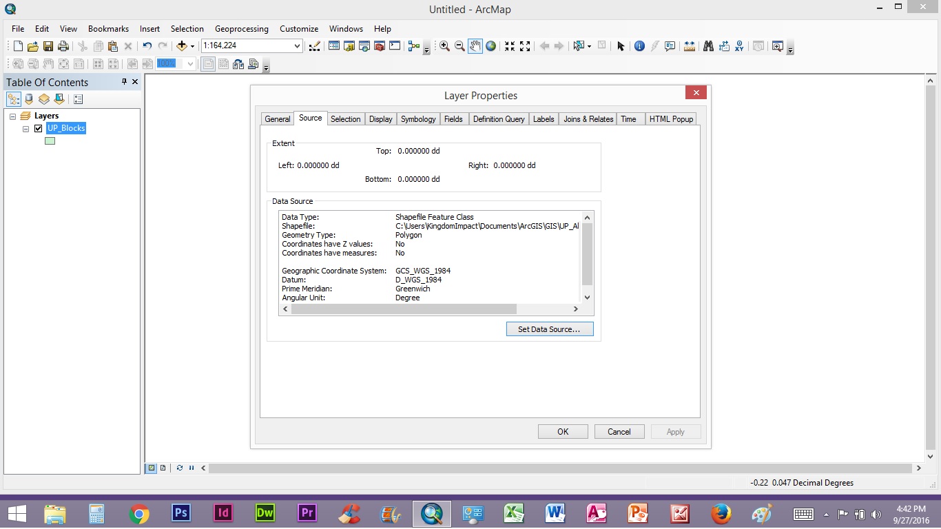
Also could you send a screenshot of the layer extent and the spatial reference (Layer properties > Source tab).
Also check the attribute table for the availability of data.
Think Location
- Mark as New
- Bookmark
- Subscribe
- Mute
- Subscribe to RSS Feed
- Permalink
- Report Inappropriate Content
Hi,
I tried to work on the suggestions you gave, like Zoom in to the layer, but found nothing to display. I looked into the attribute table and cannot find the columns it used to show when it was installed in the previous computer.
I know it got to be something relating to the path of the files which is disturbing the layer from being displayed but I don't know where to begin in the right direction in order to solve this problem.
However, I have attached some screenshots of the attribute table, as well as the errors that display with the 'Analyze Map' from the File menu.
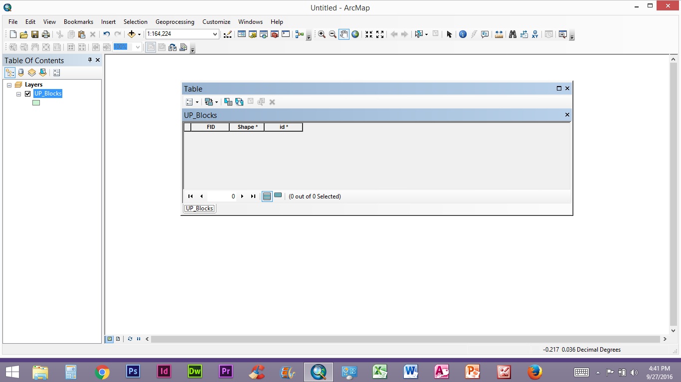
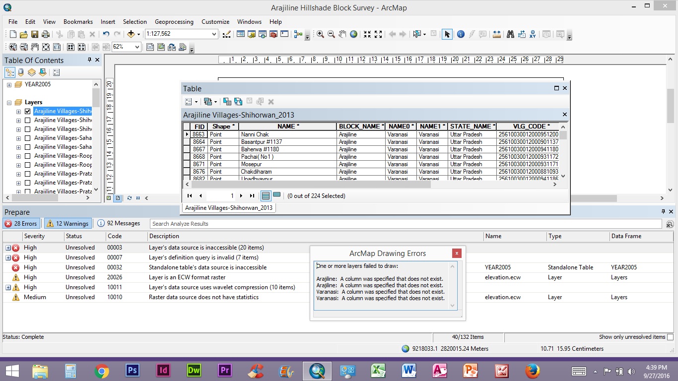
I hope this helps to look at the problem.
- Mark as New
- Bookmark
- Subscribe
- Mute
- Subscribe to RSS Feed
- Permalink
- Report Inappropriate Content
Thank you for the screenshots... The "UP_Blocks" layer doesn't seem to have any data (or remove the definition query, if any).
For other layers (in 3rd screenshot), validate the definition queries. They seem to be causing issues.
And I am suggesting you once again to move the data source to any other drive (Do not keep it inside C:\Users).
Think Location