- Home
- :
- All Communities
- :
- Products
- :
- Data Management
- :
- Data Management Questions
- :
- Re: ISSUES With CAD Dataset In ArcGIS Desktop 10.5...
- Subscribe to RSS Feed
- Mark Topic as New
- Mark Topic as Read
- Float this Topic for Current User
- Bookmark
- Subscribe
- Mute
- Printer Friendly Page
ISSUES With CAD Dataset In ArcGIS Desktop 10.5 and ArcGIS Pro
- Mark as New
- Bookmark
- Subscribe
- Mute
- Subscribe to RSS Feed
- Permalink
- Report Inappropriate Content
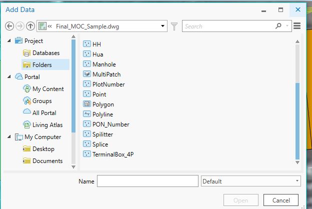
I have a AutoCAD drawing, containing AutoCAD blocks with different definition. each block contains attribute tags. When I directly add AutoCAD drawing in ArcGIS Desktop 10.5 or ArcGIS Pro 1.3, it creates separate feature class for each block on the fly in Add data dialog box or catalog window.
as shown in following snapshot all the blocks are separated as manhole, splitter, splice and terminal box feature classes since they are different AutoCAD blocks with different block name and definition.
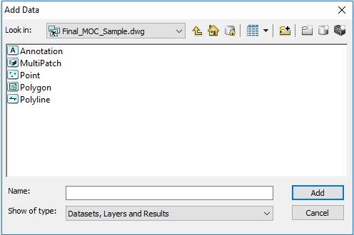
however, in ArcGIS 10.3 all the AutoCAD blocks are shown as a single Point feature class and its attribute fields were appended to its attribute table in case they are different.
Kindly review the snapshot of same data in ArcGIS Desktop 10.3 Add data dialog box.
in previous case it is very annoying to add all the blocks as separate feature layer in ArcMap. off course it also provides common point feature class but it does not contain block tag attributes.
So is there any setting to change this or what is the issue with the ArcGIS Desktop 10.5 or ArcGIS Pro to read CAD data?
any help in this regards is highly Appreciated. Thank You!
.
- Mark as New
- Bookmark
- Subscribe
- Mute
- Subscribe to RSS Feed
- Permalink
- Report Inappropriate Content
you should compare what happens when you use
http://desktop.arcgis.com/en/arcmap/latest/tools/conversion-toolbox/cad-to-geodatabase.htm
http://desktop.arcgis.com/en/arcmap/latest/tools/conversion-toolbox/import-cad-annotation.htm
Also
http://desktop.arcgis.com/en/arcmap/latest/get-started/introduction/whats-new-in-arcgis.htm
will tell you what has changed since 10.3 since things may have changed or been fixed if there is an error
- Mark as New
- Bookmark
- Subscribe
- Mute
- Subscribe to RSS Feed
- Permalink
- Report Inappropriate Content
Hi Dan,
Thank you for the information you shared.
Actually I am not using any Geoprocessing tool for conversion. I am just reading CAD drawing using "Add Data" dialog box in ArcMap, even if I read it through Catalog window it shows similar result with additional feature classes. I gone through the direct-read CAD Data model and it seams there are no changes in the documentation of ArcGIS 10.3 and ArcGIS 10.5 for CAD feature data-sets.
ArcGIS 10.5 help document shows that following are the standard feature classes for a CAD drawings. but when I add any drawing it shows additional feature classes as well, based AutoCAD block definition.
Standard feature classes
All CAD feature datasets display a standard set of five feature classes, one for each supported shape type. These feature classes display aggregate collections of geometry contained in the source CAD drawing. Their schema is hard coded and a function of the translation process. Empty feature classes cannot be removed.
- Annotation
- Multipatch
- Point
- Polygon
- Polyline
Following is the link for direct-read CAD data model.
- Mark as New
- Bookmark
- Subscribe
- Mute
- Subscribe to RSS Feed
- Permalink
- Report Inappropriate Content
Hi Madan Bhurati,
I have some similar task of conversions from CAD to GIS , if there is block it behave like that , try to Explode those blocks in ACAD and then do your job in ArcEditor,
it will gives the following features in ACAD data set.
Annotaction
Point
Polyline
Polygon
Multipoint
now you can extract lines from Layer polyline by select by attribute (layer = as per your requirement) same step for all features .
let me know if I am right , ??
Thanks
- Mark as New
- Bookmark
- Subscribe
- Mute
- Subscribe to RSS Feed
- Permalink
- Report Inappropriate Content
Actually these blocks contain Attribute tag, which is very useful information, I can't afford to loose it. I just wanted to know the root cause why ArcGIS 10.5 or ArcGIS Pro behaves differently with CAD data on direct read. Since ESRI has not documented any change on Direct read Model of CAD data.
- Mark as New
- Bookmark
- Subscribe
- Mute
- Subscribe to RSS Feed
- Permalink
- Report Inappropriate Content
Madan, did you find a solution for the problem?
I am having the same problem. I am importing CAD (.dwg) (from AUTOCAD 2014) files into ArcMap 10.5.1 and now, after the update, the CAD multiline feature class does show, but the annotation and the points CAD feature class DO NOT. I need to label these points but no annotation/text is available in their tables. I opened the same dwg file in ArcMap 10.3 and they come in just fine with the annotation available.
If anyone else can chime in with a solution/suggestion It would be appreciated.
Thanks,
Rezart