Turn on suggestions
Auto-suggest helps you quickly narrow down your search results by suggesting possible matches as you type.
Cancel
- Home
- :
- All Communities
- :
- Products
- :
- Data Management
- :
- Data Management Questions
- :
- Import elevation data from a raster (GRID) into a ...
Options
- Subscribe to RSS Feed
- Mark Topic as New
- Mark Topic as Read
- Float this Topic for Current User
- Bookmark
- Subscribe
- Mute
- Printer Friendly Page
Import elevation data from a raster (GRID) into a multipatch -Is this possible? How?
Subscribe
03-18-2013
06:35 AM
- Mark as New
- Bookmark
- Subscribe
- Mute
- Subscribe to RSS Feed
- Permalink
- Report Inappropriate Content
Hi All,
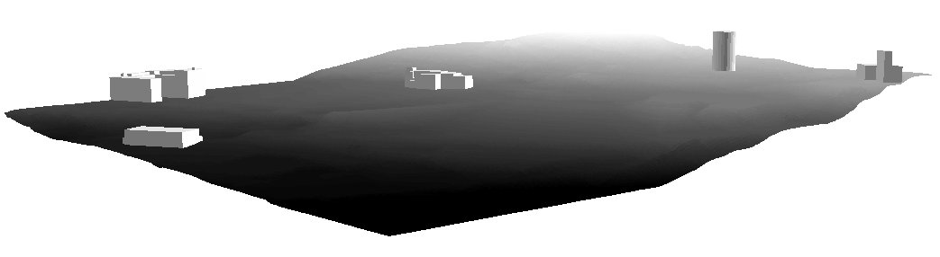
I have a raster Grid file with elevation values. In ArcScene I can display a Multipatch shapefile (or feature class) floating on top of the raster surface (see the attached screenshot), based on the elevation values of the latter (i.e. raster). However, I'm wondering if there is a way to export those elevation values from the raster and then apply them to the multipatch to store permanently (i.e. I want my multipatch to have it's own elevation values corresponding to those of the respective surface). If anyone has done anything similar, please advised on the steps required.
Thanks,
Max
Solved! Go to Solution.
1 Solution
Accepted Solutions
03-18-2013
04:42 PM
- Mark as New
- Bookmark
- Subscribe
- Mute
- Subscribe to RSS Feed
- Permalink
- Report Inappropriate Content
Hello,
After applying elevation to your multipatches from a raster surface, you can run Layer 3D to Feature Class tool which will then create another multipatch which should have the elevation information stored within the multipatches.
Regards,
Prasanta.
After applying elevation to your multipatches from a raster surface, you can run Layer 3D to Feature Class tool which will then create another multipatch which should have the elevation information stored within the multipatches.
Regards,
Prasanta.
4 Replies
03-18-2013
04:42 PM
- Mark as New
- Bookmark
- Subscribe
- Mute
- Subscribe to RSS Feed
- Permalink
- Report Inappropriate Content
Hello,
After applying elevation to your multipatches from a raster surface, you can run Layer 3D to Feature Class tool which will then create another multipatch which should have the elevation information stored within the multipatches.
Regards,
Prasanta.
After applying elevation to your multipatches from a raster surface, you can run Layer 3D to Feature Class tool which will then create another multipatch which should have the elevation information stored within the multipatches.
Regards,
Prasanta.
03-20-2013
07:11 AM
- Mark as New
- Bookmark
- Subscribe
- Mute
- Subscribe to RSS Feed
- Permalink
- Report Inappropriate Content
Hi Prasanta,
Thanks for the advise. However, when I ran the tool and added the resulting multipatch in my ArcScene, I've noticed two issues:
1) There were no elevation values associated with the new multipatch, unlike we were expecting - it was flat;
2) I couldn't even apply my raster surface elevation values to the newly created multipatch - it stays flat, and doesn't want to "float" on the surface no matter what I do.
Any thoughts on why this is happening? Any other workarounds to try for my original question?
Thanks,
Max
03-20-2013
07:29 AM
- Mark as New
- Bookmark
- Subscribe
- Mute
- Subscribe to RSS Feed
- Permalink
- Report Inappropriate Content
Hi Max,
I have checked the workflow I suggested based on my understanding of the issue, and it seems to be working for me. See the screencapture video of what I was doing. Is this not what you were trying to do?
Thanks,
Prasanta.
I have checked the workflow I suggested based on my understanding of the issue, and it seems to be working for me. See the screencapture video of what I was doing. Is this not what you were trying to do?
Thanks,
Prasanta.
03-20-2013
07:31 AM
- Mark as New
- Bookmark
- Subscribe
- Mute
- Subscribe to RSS Feed
- Permalink
- Report Inappropriate Content
Nevermind my previous post - I've figured out what the problem was. Essentially, my multipatch was in the UTM projection based on the NAD27 datum, while the surface was based on the NAD83 datum. I've re-projected the original multipatch to NAD83 UTM Zone 18N, added it to the ArcScene, applied the base-heights from the surface, and re-ran the Layer 3D to Feature Class tool - the resulting output multipatch retained the raster surface elevation values within it.
Issue solved, thanks for your help!
Max
Issue solved, thanks for your help!
Max