- Home
- :
- All Communities
- :
- Products
- :
- Data Management
- :
- Data Management Questions
- :
- I have 250 fields(comlumns) in excel. Can I create...
- Subscribe to RSS Feed
- Mark Topic as New
- Mark Topic as Read
- Float this Topic for Current User
- Bookmark
- Subscribe
- Mute
- Printer Friendly Page
I have 250 fields(comlumns) in excel. Can I create a shapefile? What is the work around?
- Mark as New
- Bookmark
- Subscribe
- Mute
- Subscribe to RSS Feed
- Permalink
- Report Inappropriate Content
I have 252 fields as a .CSV file. I would like to create a shapefile but I get the following error...
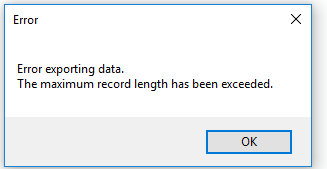
What is the work around for this?
Thanks,
- Mark as New
- Bookmark
- Subscribe
- Mute
- Subscribe to RSS Feed
- Permalink
- Report Inappropriate Content
While 250+ fields is an ugly database design, the error message is actually based on the 4000 byte record width limitation of dBase, which can be reached in as few as sixteen 254-character string fields. The dBase III specification also has a 100 field limit, which ArcGIS ignores, but it does honor the hard limit of 255 fields (field count is a single byte in the dBase header).
File geodatabase does not have the 4K buffer limitation, and supports 64K columns (which is far greater than the database limitations of 256 or 512, depending on ArcGIS version).
So your options are to slice the the table width to something that dBase can support or to use a format other than shapefile.
- V
- Mark as New
- Bookmark
- Subscribe
- Mute
- Subscribe to RSS Feed
- Permalink
- Report Inappropriate Content
There is also a limit of 10 for field name widths. You have several fields that are 11 wide. Also we don't support field names that start with a number, which you have several of.
CORRECTION: I reviewed our support for leading numbers in field names and I'm incorrect. We have no problem with leading numbers in shapefile field names and handle it when copy/pasting or exporting into another datasource that does not support leading numbers in field names.
- Mark as New
- Bookmark
- Subscribe
- Mute
- Subscribe to RSS Feed
- Permalink
- Report Inappropriate Content
Just asking for a clarification on the original question: Was the error box you show was encountered in Excel?
- Mark as New
- Bookmark
- Subscribe
- Mute
- Subscribe to RSS Feed
- Permalink
- Report Inappropriate Content
In ArcGIS
- Mark as New
- Bookmark
- Subscribe
- Mute
- Subscribe to RSS Feed
- Permalink
- Report Inappropriate Content
What of the suggestions listed in the above have you tried?
If you need to retain a shapefile output, then you have to overcome the limitations.
Have you tried the geodatabase option?
- Mark as New
- Bookmark
- Subscribe
- Mute
- Subscribe to RSS Feed
- Permalink
- Report Inappropriate Content
Hi Dan,
I personally prefer feature class in file geodatabase instead of shapefile for this. It works but the clients want shapefile as they don't understand GIS very well and gets lost when I tell them the similarities and differences between feature class and shapefile. I think I will shrink the number of fields to 140-150 field and see if that could help to create a shapefile.
- Mark as New
- Bookmark
- Subscribe
- Mute
- Subscribe to RSS Feed
- Permalink
- Report Inappropriate Content
I would gently guide them by setting things up by perhaps delivering a package of some form, so that they can open a project and it miraculously opens with the table ready for viewing and the dataframe fully set up.
It would be worthwhile to point out to them that having even 150 fields is going to be difficult to view, organize and comprehend.
A push in the right direction would certainly make your task less onerous and it will head off those...
"on second thought can you... " type requests which will inevitably follow.
Good luck
- Mark as New
- Bookmark
- Subscribe
- Mute
- Subscribe to RSS Feed
- Permalink
- Report Inappropriate Content
Don't forget about the 4000 byte record limit. You could store all the fields if the mean field width is less than 16.
Other products may enforce the 100 field limit of dBase, in which case the "140-150" field count would still fail (just later in the conversion process).
- V
- Mark as New
- Bookmark
- Subscribe
- Mute
- Subscribe to RSS Feed
- Permalink
- Report Inappropriate Content
OK, I was confused by your title of "I have 250 .... in excel" as meaning you were working in Excel. Are you just using the term excel in a generic sense to mean any table not associated with a current spatial data layer?
- Mark as New
- Bookmark
- Subscribe
- Mute
- Subscribe to RSS Feed
- Permalink
- Report Inappropriate Content
I initially created intersection points in ArcMap, added X-Y coordinates to those points and exported the table to .csv. Now I am manually entering data in the excel table. Once I am done I intend to import the table in GIS and create a shapefile using the X-Y coordinates.
I included a sample of 5 rows of my table. The final table will have anywhere between 470 and 500 rows.
- « Previous
-
- 1
- 2
- Next »
- « Previous
-
- 1
- 2
- Next »