Turn on suggestions
Auto-suggest helps you quickly narrow down your search results by suggesting possible matches as you type.
Cancel
- Home
- :
- All Communities
- :
- Products
- :
- Data Management
- :
- Data Management Questions
- :
- Re: how to make an address locator for township-ra...
Options
- Subscribe to RSS Feed
- Mark Topic as New
- Mark Topic as Read
- Float this Topic for Current User
- Bookmark
- Subscribe
- Mute
- Printer Friendly Page
how to make an address locator for township-range-section polygons
Subscribe
01-22-2014
07:49 AM
- Mark as New
- Bookmark
- Subscribe
- Mute
- Subscribe to RSS Feed
- Permalink
- Report Inappropriate Content
Hello all,
As stated im having troubles making an address locator to show land ownership
1 company owns 4000+++ peices of land which i have on an excell spreadsheet broken town to Township Range Section
i have the state sections breakdown date
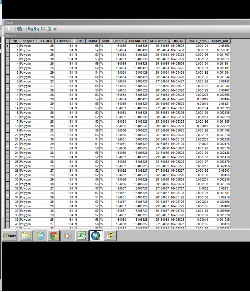
the table looks like this
but im stuck at this.
Im guessing i need to add an alia refrence data of my collected data from my spreadsheets but im unsure how to arrange that and if i can just add a excel file
As stated im having troubles making an address locator to show land ownership
1 company owns 4000+++ peices of land which i have on an excell spreadsheet broken town to Township Range Section
i have the state sections breakdown date
the table looks like this
but im stuck at this.
Im guessing i need to add an alia refrence data of my collected data from my spreadsheets but im unsure how to arrange that and if i can just add a excel file
Solved! Go to Solution.
21 Replies
01-23-2014
08:50 AM
- Mark as New
- Bookmark
- Subscribe
- Mute
- Subscribe to RSS Feed
- Permalink
- Report Inappropriate Content
For the second, probably the formula did not export. You will have to convert the formula to actual values. To keep your original data with the formulas select everything on the page and then use the Paste Special - Values Only on a new tab of the Spreadsheet to convert the formula to value. Then retry the export/import of the Excel table using the second sheet.
Lets forget about the time format issue until the normal layer behavior for drawing and joining is solved.
alright i did what you said and imported a new table that has no formula only the values. Doing so TWPRNGSEC Owner columns are listed as text data fields and cannot be alter nor show up in the drop menu when trying to join? It gives me an error when trying to change them to double.
01-23-2014
10:31 AM
- Mark as New
- Bookmark
- Subscribe
- Mute
- Subscribe to RSS Feed
- Permalink
- Report Inappropriate Content
alright i did what you said and imported a new table that has no formula only the values. Doing so TWPRNGSEC Owner columns are listed as text data fields and cannot be alter nor show up in the drop menu when trying to join? It gives me an error when trying to change them to double.
You can't change the type, but you can change the name in a File Geodatabase in ArcCatalog. So change the name and call the exported field TRSTXT instead to match the name of the Text Field in the Section table. Then create a new field and give it the TWPRNGSEC name and make it a long or double field. Then use the Field Calculator to calculate the TRSTXT field text values into it. As long as every text value is a valid number the calculation will do the conversion and not give you any error. An error would occur if a non-numeric value is in that column, but you can tell the calculation to proceed and it will convert what it can. Then everything will join fine (except any records that threw an error, which would not have worked anyway).
These types of hurdles are not uncommon with GIS, especially when conversions are involved, but after a while you learn what works and what doesn't and it gets faster overcoming these kinds of glitches. These kinds of glitches are why I generally avoid using Excel, because it is not a real database and makes faulty assumptions during conversion to a real database.
I assume the Section layer display problem is resolved.
01-23-2014
11:45 AM
- Mark as New
- Bookmark
- Subscribe
- Mute
- Subscribe to RSS Feed
- Permalink
- Report Inappropriate Content
01-23-2014
11:51 AM
- Mark as New
- Bookmark
- Subscribe
- Mute
- Subscribe to RSS Feed
- Permalink
- Report Inappropriate Content
The new ownership shows up but doesnt display on the map?
is there a setting im unaware of?
Now that you have a successful join you have to use the joined fields to change the layer properties to use them. You could change the Label tab settings to display owner names from the joined fields or you could change the Symbology tab settings to show different fill or outline colors or hatch symbols based on different ownerships using a Categorized symbol legend list. Your owner table is only township/range/section data, which the Section table already had. So the owner table may needs more fields about the owners to be useful for making the layer show ownership information.
Since the ownership was all for one company then you could make the Symbology Categories only show NULL values in the list for the TWPRNGSEC field with a background symbol for that value, and then assign a fill symbol intended for your company to the All Other Values option and rename that option with the Company name. You would have to have a field that had the company name in every record of the Company table to make the symbology work where the category list has the company name and the All Other Values option is showing a background symbol for lands not owned by the company.
Or else you could make a simple fill symbol for the whole layer and set a Definition Query tab to:
NOT JoinTable.TWPRNGSEC IS NULL
JoinTable is just a dummy name value. Use the field list to substitute the actual qualified join field name in the expression from the Joined table. This will filter the layer to only show sections that are actually in the table that the company owns. Then you would have to have the map showing an area where the company owns some sections and does not own other to see the full effect of those symbology settings. You could optionally use that expression to select company owned Sections with a Select By Attributes query also.
01-24-2014
07:29 AM
- Mark as New
- Bookmark
- Subscribe
- Mute
- Subscribe to RSS Feed
- Permalink
- Report Inappropriate Content
alright i totally understand what your talking about with editing the symbol and i can do it with any other file i load, but i cant edit anything on the joined file? its like invisible? while its loading when i make a change i can see that my land is displayed but its covered by the base map and wont display further? It acts as transparent but isnt.
01-24-2014
09:06 AM
- Mark as New
- Bookmark
- Subscribe
- Mute
- Subscribe to RSS Feed
- Permalink
- Report Inappropriate Content
alright i totally understand what your talking about with editing the symbol and i can do it with any other file i load, but i cant edit anything on the joined file? its like invisible? while its loading when i make a change i can see that my land is displayed but its covered by the base map and wont display further? It acts as transparent but isnt.
I don't follow what you are describing. I assume the layer is above the base map in the table of contents so that it is not actually covered by the base map (layer order matters). Beyond that I am not sure what you have configured. Do you have any a transparent setting value in the layer Display tab? A picture of the map and table of contents and possibly the layer symbology tab would help me understand what you have set up.
But you are correct that by design joined data cannot be edited directly in a joined table, only the original table that the data was joined to can be edited in that view. The joined data has to be edited through the original unjoined table view of the join data source. There may be a delay for the refresh that has to be forced after each edit to make the join show the edit effect and the edit may have to be saved.
Or are you saying you cannot change the actual symbology? If that is the case create two copies of the layer and make one unjoined and the other joined. Use a simple symbol in both and make sure the joined version is on top of the other. Make the lower layer show the background symbol for all sections. Make the joined layer above it solid to cover up the lower layer and set the Definition Query tab to have the expression:
NOT joinedTable.TWPRNGSEC IS NULL
Only edit your owner table directly and force a refresh after editing it. See the pictures that hopefully explain the way I want you to set everything up. I did it with my Section data. In my case I used a field called UNIQNUM to create the join for my Owner_Test table.
01-24-2014
10:58 AM
- Mark as New
- Bookmark
- Subscribe
- Mute
- Subscribe to RSS Feed
- Permalink
- Report Inappropriate Content
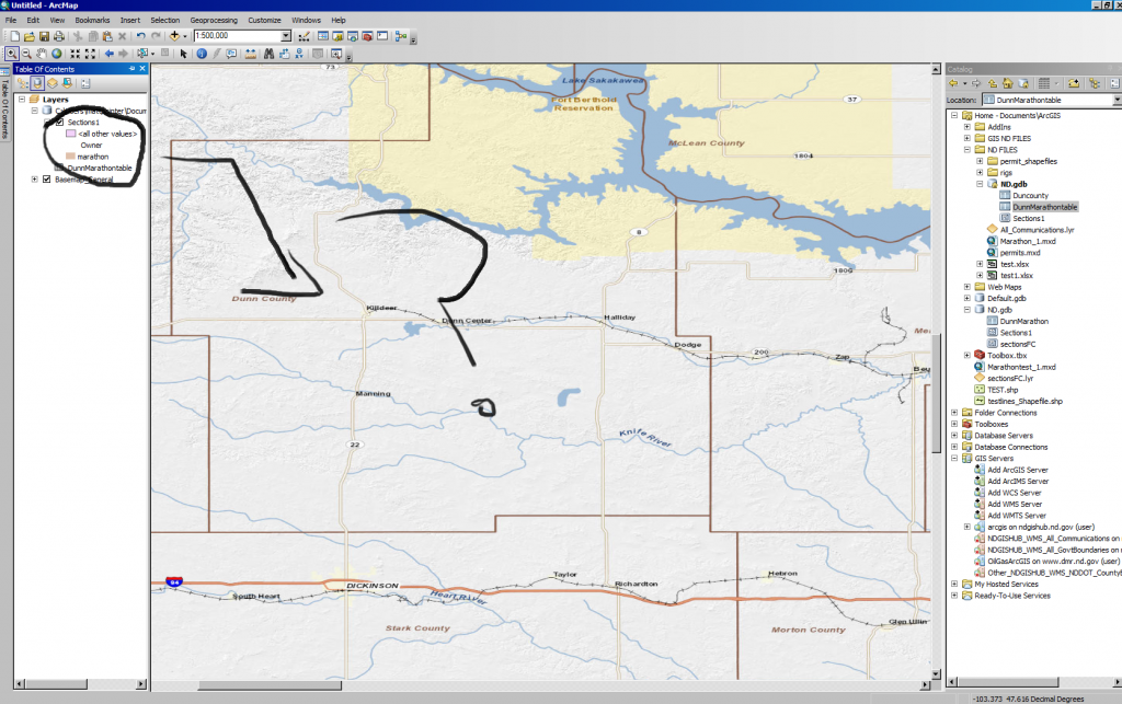
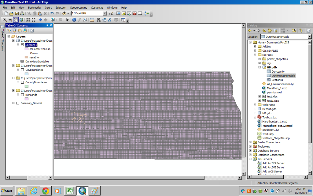
Alright i do understand i would have to edit the original table to make changes like that and force a restart but thats not what im talking about. these photos will shed some light on my problem
First photo
This photo shows the entire sections that has been joined with my data now how to i get my data to display over my other layers disregarding null values so it doesnt cover everything?
First photo
This photo shows the entire sections that has been joined with my data now how to i get my data to display over my other layers disregarding null values so it doesnt cover everything?
01-24-2014
12:59 PM
- Mark as New
- Bookmark
- Subscribe
- Mute
- Subscribe to RSS Feed
- Permalink
- Report Inappropriate Content
Alright i do understand i would have to edit the original table to make changes like that and force a restart but thats not what im talking about. these photos will shed some light on my problem
First photo
This photo shows the entire sections that has been joined with my data now how to i get my data to display over my other layers disregarding null values so it doesnt cover everything?
Do what I did. I told you to stop using a Categorized Symbology and make a layer with a single symbol that only shows the ownership and not every section. Use a Definition Query to do the filter to only show the company (see my second screen shot). Make the symbology less transparent by changing the setting on the Display tab (screen shot your Display tab for me. Do exactly what I did in my screenshots (except of course change the field name to match your table and filtering field).
If you still want all sections to display with a different transparent setting, add the Sections in again as a separate unjoined layer and make sure the unfiltered Section layer is below your company layer. If the base map covers everything, prove you can put any other layer layer on top of it. I don't use base maps. My County has all of the data that created ESRIs base maps so I create my own from the original data.
Your real layer order is not shown in the Table of Contents, since you are on the Source tab view of the Table of Contents. Switch to the Display view and show the real layer order. (The buttons at the top left corner of the Table of Contents dockable window.) The Source Tab view button is pressed (the one that looks like a database tank with a folder below it), The Display tab button looks like a folder tree.
Trash that layer and add the Section layer fresh, then add the join (don't add the table again or remove the table). If you add the layer again it should be really on the top level.
01-24-2014
01:45 PM
- Mark as New
- Bookmark
- Subscribe
- Mute
- Subscribe to RSS Feed
- Permalink
- Report Inappropriate Content
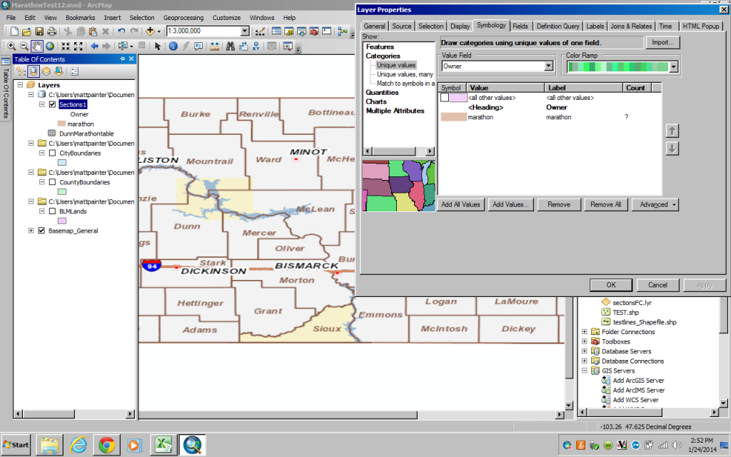
Here is a screenshot of something I set up in about 10 minutes with a Basemap background, transparent hollow sections and solid company sections. If you can;t do this with your current map start a fresh map and do these steps in this order:
Switch your table of Contents to Display tab view.
First add the Basemap.
Now add two copies of the Section layer.
Change the symbology of the bottom Section layer properties to hollow on the Symbology tab and to 70% transparent on the Display tab.
On the top Section layer properties, change the layer name to your company name on the General Tab, change the single symbol on the Symbology tab to a solid color.
Join the top Section layer to your company data (don't add the table to the map, just use the browse button on the Join properties window to add the table to the join table slot) and complete the join.
Go to the Definition Query tab and make it:
NOT YourCompanyTable.TWPRNGSEC IS NULL
Substitute the table name you created for the YourCompanyName in the expression above by clicking that field in the field list to replace that text.
If that does not work, either something is wrong with ArcMap or your not following my instructions in the right order.
01-24-2014
01:50 PM
- Mark as New
- Bookmark
- Subscribe
- Mute
- Subscribe to RSS Feed
- Permalink
- Report Inappropriate Content
Here is a screenshot of something I set up in about 10 minutes with a Basemap background, transparent hollow sections and solid company sections. If you can't do this with your current map start a fresh map and do these steps in this order:
Switch your table of Contents to Display tab view.
First add the Basemap.
Now add two copies of the Section layer.
Change the symbology of the bottom Section layer properties to hollow on the Symbology tab and to 70% transparent on the Display tab.
On the top Section layer properties, change the layer name to your company name on the General Tab, change the single symbol on the Symbology tab to a red solid color.
Join the top Section layer to your company data (don't add the table to the map, just use the browse button on the Join properties window to add the table to the join table slot) and complete the join. (if you do add the table to the map, switch the Table of Content view back from Source view to Display view, since adding a table automatically places you in Source view).
Go to the Definition Query tab and make it:
NOT YourCompanyTable.TWPRNGSEC IS NULL
Substitute the table name you created for the YourCompanyName in the expression above by clicking that field in the field list to replace that text.
If that does not work, either your not following my instructions in the right order or something is wrong with your ArcMap installation. After you get this to work to recreate what I have done then you can mess with the symbology to fit your exact design ideas.