Turn on suggestions
Auto-suggest helps you quickly narrow down your search results by suggesting possible matches as you type.
Cancel
- Home
- :
- All Communities
- :
- Products
- :
- Data Management
- :
- Data Management Questions
- :
- Re: How to estimate the temperature of a LandSAT I...
Options
- Subscribe to RSS Feed
- Mark Topic as New
- Mark Topic as Read
- Float this Topic for Current User
- Bookmark
- Subscribe
- Mute
- Printer Friendly Page
How to estimate the temperature of a LandSAT Image based on the Band 6 raster data?
Subscribe
08-01-2012
05:46 AM
- Mark as New
- Bookmark
- Subscribe
- Mute
- Subscribe to RSS Feed
- Permalink
- Report Inappropriate Content
Hi,
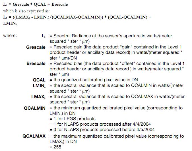
I have several LandSAT 5 Images including the midinfrared ones that correspond to the Band 6 raster data. As my graduation project I have to estimate the temperature that each pixel (which go from 0-255) represents. So long I've found the equation that will allow me to estimate the temperature, but I'm relatively new to ArcGIS and don't know of any tools or functions that will allow me to assign temperature values to the cells, depending on the values they already have. There are two equations to get temperature values form this LandSAt images. These are as follows:
Equation 1. Obtaining Radiance
Lλ = ((LMAXλ - LMINλ)/(QCALMAX-QCALMIN)) * (QCAL-QCALMIN) + LMINλ
where:
Lλ = Spectral Radiance at the sensor's aperture in watts/(meter squared * ster * µm)
Grescale = Rescaled gain (the data product "gain" contained in the Level 1 product header or ancillary data record) in watts/(meter squared * ster * µm)/DN
Brescale = Rescaled bias (the data product "offset" contained in the Level 1 product header or ancillary data record ) in watts/(meter squared * ster * µm)
QCAL = the quantized calibrated pixel value in DN
LMINλ= the spectral radiance that is scaled to QCALMIN in watts/(meter squared * ster * µm)
LMAXλ = the spectral radiance that is scaled to QCALMAX in watts/(meter squared * ster * µm)
QCALMIN = the minimum quantized calibrated pixel value (corresponding to LMINλ) in DN = 1 for LPGS products = 1 for NLAPS products processed after 4/4/2004 = 0 for NLAPS products processed before 4/5/2004
QCALMAX = the maximum quantized calibrated pixel value (corresponding to LMAXλ) in DN = 255
Equation 2. Obtaning Temperature y Kelvin
T= K2/(ln*(K1/Lλ+1) )
Where: T = Effective at-satellite temperature in Kelvin
K2 = Calibration constant 2 from Table 11.5 K1 = Calibration constant 1 from Table 11.5
L = Spectral radiance in watts/(meter squared * ster * µm)
I alerady know all the constants, but I wouldn't know how to apply this to my image so that the pixels represent temeprature instead of just a value from 0-255.
Thanks for anyone who can help me out with this.
Solved! Go to Solution.
1 Solution
Accepted Solutions
08-01-2012
06:58 AM
- Mark as New
- Bookmark
- Subscribe
- Mute
- Subscribe to RSS Feed
- Permalink
- Report Inappropriate Content
2 Replies
08-01-2012
06:58 AM
- Mark as New
- Bookmark
- Subscribe
- Mute
- Subscribe to RSS Feed
- Permalink
- Report Inappropriate Content
08-01-2012
07:21 AM
- Mark as New
- Bookmark
- Subscribe
- Mute
- Subscribe to RSS Feed
- Permalink
- Report Inappropriate Content
If you know your constants, can't you just use the raster calculator?
Hmmmmm I'll try to do it using the raster calculator and see what I get. As I said before, I'm relatively new to ArcGIS so I don't know many tools to do what I want. Thanks a lot for your answer, I'll reply after I give it a try.