- Home
- :
- All Communities
- :
- Products
- :
- Data Management
- :
- Data Management Questions
- :
- How to allocate attributes of an area as a percent...
- Subscribe to RSS Feed
- Mark Topic as New
- Mark Topic as Read
- Float this Topic for Current User
- Bookmark
- Subscribe
- Mute
- Printer Friendly Page
How to allocate attributes of an area as a percentage of overlapping area
- Mark as New
- Bookmark
- Subscribe
- Mute
- Subscribe to RSS Feed
- Permalink
- Report Inappropriate Content
I am fairly new to ArcGIS, but I am looking for help in performing a specific function. I am trying to analyze a transit system and I have a point layer with all stops in the network that contains information about each stop, as well as the ridership that boarded at that stop. I've created circular buffer areas around each stop to represent the expected catchment area for the stop. I also have a layer of block groups with information about population, income, etc.
What I would like to do is to be able to allocate the ridership at each stop based on the amount of area of the buffer that overlaps a particular block group. That is, if a particular stop's buffer area overlaps two block groups evenly, I want to be able to distribute the ridership at that stop 50/50 to both block groups. Ultimately, I want to obtain a table with each block group and the total (for all stops whose buffer area overlaps the block group) "distributed" ridership for that block group. I've attached a sketch that hopefully explains what I am trying to do. I was already able to do this without buffer areas by just grouping the ridership for those stops that fall in each block group, but I don't think this is realistic enough for what I am trying to do. I've been reading through the community here and watching a lot of videos on YouTube but haven't been able to find anything to do what I would like yet. Any sort of help would be greatly appreciated. Thanks in advance!
Solved! Go to Solution.
Accepted Solutions
- Mark as New
- Bookmark
- Subscribe
- Mute
- Subscribe to RSS Feed
- Permalink
- Report Inappropriate Content
If you have an advanced license... look at Tabulate Intersection
Some of the other Statistics tools don't require an advanced or standard license, so give them a look.
You can probably emulate any advanced level tool with a little extra work if needed.
- Mark as New
- Bookmark
- Subscribe
- Mute
- Subscribe to RSS Feed
- Permalink
- Report Inappropriate Content
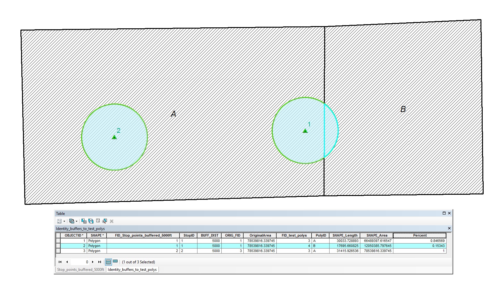
There are several ways to do this. Here's one workflow to find the proportional amount of each block group within the bus stop buffers:
- Add a new field to your buffered stops polygons. Call it OriginalArea or something similar. Make it its field type double.
- Use Field Calculator to populate this new field with the value from the Shape.Area field for each polygon in the buffered stops feature class. Making simple field calculations—Help | ArcGIS Desktop
- Run the Identity geoprocessing tool Identity—Help | ArcGIS for Desktop . When running the tool, the Input Layer will be the buffers and the Identity Layer will be the Block Group polygons.
- In the resulting output, add a new field called Percent. Using Field Calculator, derive the percent by dividing the Shape.Area field by the OriginalArea field.
Notes/Caveats:
- Identity requires an Advanced License. You can do a similar process with the tools available at the basic license, but it will take several more steps to essentially duplicate Identity.
- The Identity step will have to be run one buffer polygon at a time to avoid issues where there are overlapping buffer polygons. If it is desired to automate this aspect, it can be done with Modelbuilder or via Python Scripting.
Chris Donohue, GISP
- Mark as New
- Bookmark
- Subscribe
- Mute
- Subscribe to RSS Feed
- Permalink
- Report Inappropriate Content
Thanks for the suggestions. With a little manipulation, it seems like the suggested approaches will get me what I am looking for.