- Home
- :
- All Communities
- :
- Products
- :
- Data Management
- :
- Data Management Questions
- :
- How can we mosaic multiple raster images from sepa...
- Subscribe to RSS Feed
- Mark Topic as New
- Mark Topic as Read
- Float this Topic for Current User
- Bookmark
- Subscribe
- Mute
- Printer Friendly Page
How can we mosaic multiple raster images from separate folders?
- Mark as New
- Bookmark
- Subscribe
- Mute
- Subscribe to RSS Feed
- Permalink
- Report Inappropriate Content
I have 380 DEMs. All the rasters are in .tif format. I am trying to mosaic them together. But the issue is that every raster image is in a separate folder. There are 380 folders for the 380 different rasters. I have tried creating a file geodatabase, adding a raster catalog and then adding the DEMs to the catalog. But it did not work.
I have also tried creating an empty mosaic dataset and adding rasters to it.
The issue basically is that every raster is in a separate folder and mosaicking them individually is not a feasible option.
Kindly suggest a solution!
dem mosaic raster mosaic dataset
- Mark as New
- Bookmark
- Subscribe
- Mute
- Subscribe to RSS Feed
- Permalink
- Report Inappropriate Content
Creating a mosaic dataset—Help | ArcGIS for Desktop
- The Include Sub Folders check box should be checked. This option will recursively explore any subfolders containing the data being added.
- Mark as New
- Bookmark
- Subscribe
- Mute
- Subscribe to RSS Feed
- Permalink
- Report Inappropriate Content
Thank you for your reply.
But we had already checked the sub-folder option while adding rasters to the mosaic dataset. Just for your convenience the folder structure that we have right now is:
- Main Folder 1
- Sub-folder 1
- Raster
- Sub-folder 2
- Raster
- .....
- Sub-folder 1
- Main Folder 2
- Sub-folder 1
- Raster
- Sub-folder 2
- Raster
- ......
- Sub-folder 1
Like this we have four main folders and approximately 50-60 sub-folders within each main folder and every sub-folder has one raster each. So how do we iterate between these folders?
- Mark as New
- Bookmark
- Subscribe
- Mute
- Subscribe to RSS Feed
- Permalink
- Report Inappropriate Content
Have you tried Adding raster data to a mosaic dataset—Help | ArcGIS for Desktop with the "Workspace" option?
I tried it three different ways (with 3-main, 2ith 2 subfolders unders each, with on raster.
- adding all the sub-folder x (i,.e 6 folders),
- adding all the Main folders (i.e. 3)
- adding a top folder with the structure you have.
All three of these had the same result, so I think if all your "Main Folder X" folders are in a separate "top folder" you should be able to run this command once. I've done a similar process with about 56k raster,
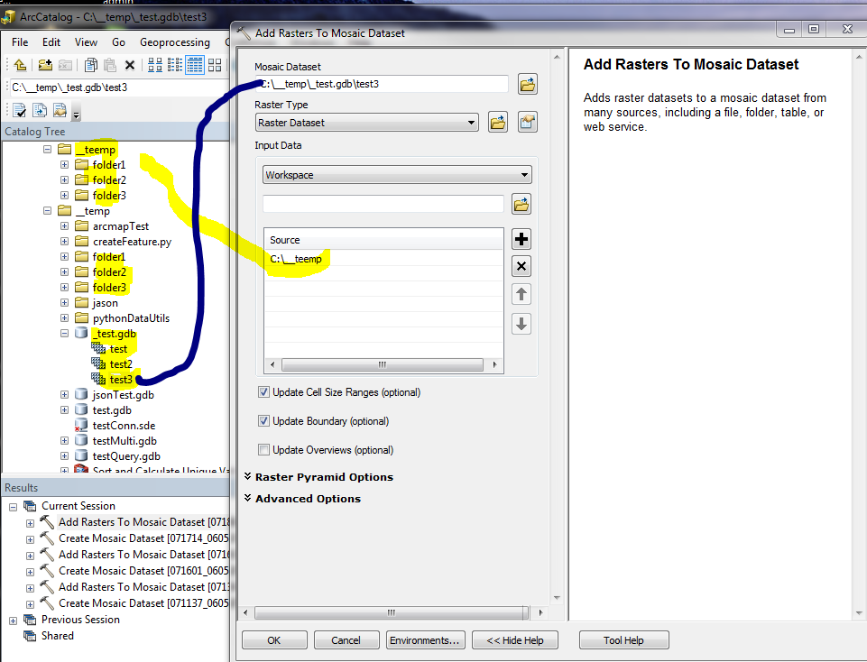
Copy of the python snippet.......most are the default options....I only entered the info in the above window.
arcpy.AddRastersToMosaicDataset_management(in_mosaic_dataset="C:/__temp/_test.gdb/test3", raster_type="Raster Dataset", input_path="C:\__teemp", update_cellsize_ranges="UPDATE_CELL_SIZES", update_boundary="UPDATE_BOUNDARY", update_overviews="NO_OVERVIEWS", maximum_pyramid_levels="", maximum_cell_size="0", minimum_dimension="1500", spatial_reference="", filter="#", sub_folder="SUBFOLDERS", duplicate_items_action="ALLOW_DUPLICATES", build_pyramids="NO_PYRAMIDS", calculate_statistics="NO_STATISTICS", build_thumbnails="NO_THUMBNAILS", operation_description="#", force_spatial_reference="NO_FORCE_SPATIAL_REFERENCE")