- Home
- :
- All Communities
- :
- Products
- :
- Data Management
- :
- Data Management Questions
- :
- Re: How can I get ArcGIS pro to read Digital Globe...
- Subscribe to RSS Feed
- Mark Topic as New
- Mark Topic as Read
- Float this Topic for Current User
- Bookmark
- Subscribe
- Mute
- Printer Friendly Page
How can I get ArcGIS pro to read Digital Globe's .rpb file so that I can orthorectify images?
- Mark as New
- Bookmark
- Subscribe
- Mute
- Subscribe to RSS Feed
- Permalink
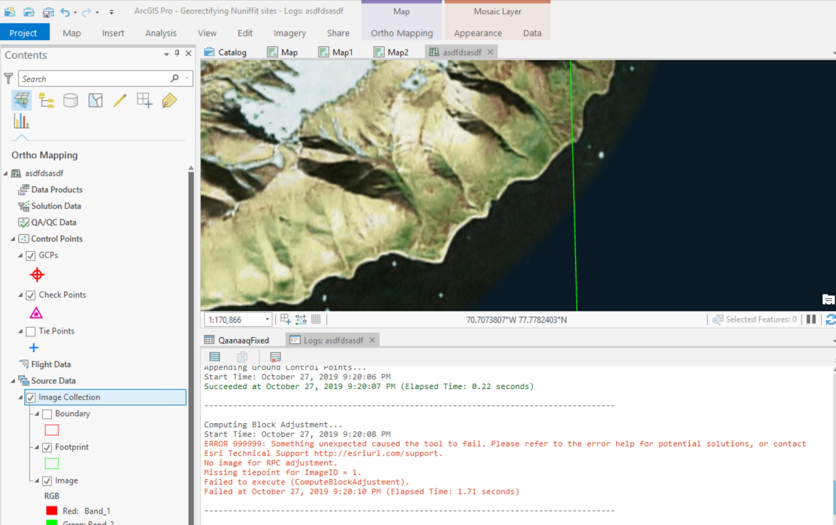
I think I'm way out of my depth, and have been trying to orthorectify Worldview images from Digital Globe for weeks without results. It seems to me that the problem is getting ESRI software to read the RPC information which is actually stored in an .rpb file. I have the ORstandard2A bundle of images -- so there are seperate .rpb files for both the Multo and Pan images.
I go through the steps to do a block adjustment, via the Ortho Mapping workspace. I have a good DEM for the area, but when I run the block adjustment it always runs into an error, and says "no image for RPC adjustment".
Have been through any and every discussion on .rpb files without an insight - any help you can offer is much appreciated. Thanks
Solved! Go to Solution.
Accepted Solutions
- Mark as New
- Bookmark
- Subscribe
- Mute
- Subscribe to RSS Feed
- Permalink
Note that you do not need to use Ortho Maping to orthorectify imagery is you are using existing RPC data and do not need to generate new terrain models or work with large collections
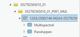
To orthorectify the imagery just add the image to ArcGIS Pro using the Raster Product. IE in catalog just navigate to to the Multispectral directory location.
Drag and drop the Pansharped product into the map.
The image will be displayed but will not be orthorectified. The values from the RPB will be ingested but initially no terrain model is defined. Open 'Edit Function Chain' for that layer and you should see following
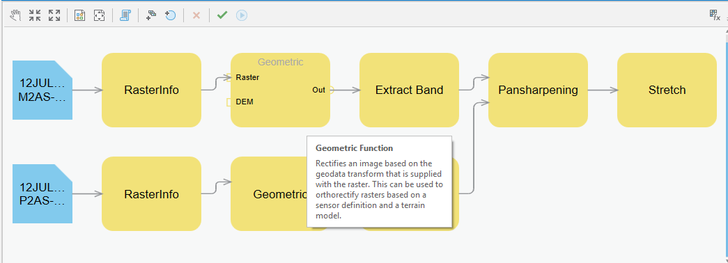
This shows function chain being applied to the image Note no DEM is defined.
Double click on one of the Geometric functions.
Change Method to Use DEM
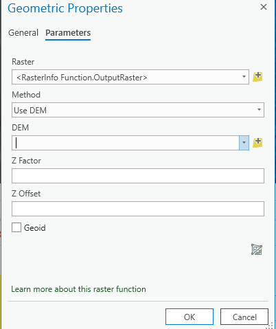
Then specify the DEM you want to use.
Note that if the DEM is orthometric (which is the case for most DEMs) then you need to click on
Repeat the same for the other geometric function (pan or MS).
Validate and Apply.
The image will not be orthorectified.
Drag in the same product (without applying DEM) to see the differences.
If have ground control and want to refine the geometric accuracy you can use the Georeferencing tools or use Ortho Mapping depending on the level and size of the project you want to undertake.
- Mark as New
- Bookmark
- Subscribe
- Mute
- Subscribe to RSS Feed
- Permalink
- Mark as New
- Bookmark
- Subscribe
- Mute
- Subscribe to RSS Feed
- Permalink
Note that you do not need to use Ortho Maping to orthorectify imagery is you are using existing RPC data and do not need to generate new terrain models or work with large collections
To orthorectify the imagery just add the image to ArcGIS Pro using the Raster Product. IE in catalog just navigate to to the Multispectral directory location.
Drag and drop the Pansharped product into the map.
The image will be displayed but will not be orthorectified. The values from the RPB will be ingested but initially no terrain model is defined. Open 'Edit Function Chain' for that layer and you should see following
This shows function chain being applied to the image Note no DEM is defined.
Double click on one of the Geometric functions.
Change Method to Use DEM
Then specify the DEM you want to use.
Note that if the DEM is orthometric (which is the case for most DEMs) then you need to click on
Repeat the same for the other geometric function (pan or MS).
Validate and Apply.
The image will not be orthorectified.
Drag in the same product (without applying DEM) to see the differences.
If have ground control and want to refine the geometric accuracy you can use the Georeferencing tools or use Ortho Mapping depending on the level and size of the project you want to undertake.
- Mark as New
- Bookmark
- Subscribe
- Mute
- Subscribe to RSS Feed
- Permalink
Hi Peter,
Thanks very much for your reply -- it's very helpful and opened things a bit more.
This has produced much better results for me, but I am still having a bit of trouble.
1) I have images from different years that I'm comparing... one is Worldview 2 and the other is Worldview 4. Using your method and adding my DEM to the geometric functions for both has made them much closer. However, I'm not sure they are actually "orhorectified". I can georeference them now so that some parts of the images are probably close enough for my purposes.... but if I look elsewhere in the image, it is still off. This seems to be points at higher elevation... the coatline seems fine, but the tops of the mountains don't line up. Am I right in saying that is unavoidable because of the sensor's angle?
2) I noticed that once I apply the DEM to the geometric functions, it seems to change how the pansharpened image looks. For example, it is suddenly much darker even though the pansharpen settings seem to remain the same. Out of curiousity, why is that?
Thanks again!
- Mark as New
- Bookmark
- Subscribe
- Mute
- Subscribe to RSS Feed
- Permalink
Just to add to that second point on the pan sharpening. The images are before and after the changes to the geometric functions.


- Mark as New
- Bookmark
- Subscribe
- Mute
- Subscribe to RSS Feed
- Permalink
The accuracy of the Orthoimage will depend on the accuracy of the RPB (or correction you make to it); the accuracy of the DEM and the sensor look angle. Do check the DEM that you are using. On steeper slopes and with image at less nadir look angles you will see more artifacts.
The orthorectification will not affect the radiometry, but the pansharpening can. Do check the pansharpening method. If you are using Gram Schmidt do ensure you compute stats on the MS and Pan Image first. The Gram Schmidt method uses covariance value that are computed with the image statistics.
The imagery you have is probably 16bit so there is a lot of dynamic range. In areas with dark shadow and snow this dynamic range is very valuable. Suggest you use the DRA capabilities that are part of the appearance tab. The apparent dark image may be that you have DRA on and are now zoomed to an area that includes white snow so the system dynamically makes the image darker to allow details in the snow. You can also set the stretch to be applied.
- Mark as New
- Bookmark
- Subscribe
- Mute
- Subscribe to RSS Feed
- Permalink
Fantastic - thanks so much your your help. This was very useful and I think i've got the pansharpening worked out better.
- Mark as New
- Bookmark
- Subscribe
- Mute
- Subscribe to RSS Feed
- Permalink
Hi George,
Peter is correct. You do not need to use Ortho Mapping if you only want to orthorectify one satellite scene. But you have GCP data and want to improve the geometric accuracy before orthorectify, you can use Ortho Mapping. The steps are
1. create an ortho mapping workspace and set your better DEM in the data loader option
2. since you only have one image, you can skip the Adjust tool and using GCP manager to import your GCPs and measure the corresponding tie points
3. Then you run Adjust tool
4. To save an output, you can use the the custom product wizard, and with only the last option on

and set the output pixel size and format. you can also provide your good DEM here if you didn't use when you create ortho mapping workspace

Hope that helps. Please let us know if you have different scenario.
- Mark as New
- Bookmark
- Subscribe
- Mute
- Subscribe to RSS Feed
- Permalink
Thanks - I was able to use Peter's method. I'll give this a try too. Much appreciated.