- Home
- :
- All Communities
- :
- Products
- :
- Data Management
- :
- Data Management Questions
- :
- Re: DTM editing
- Subscribe to RSS Feed
- Mark Topic as New
- Mark Topic as Read
- Float this Topic for Current User
- Bookmark
- Subscribe
- Mute
- Printer Friendly Page
DTM editing
- Mark as New
- Bookmark
- Subscribe
- Mute
- Subscribe to RSS Feed
- Permalink
Dear,
I'm having problems editing my DTM (Tiff format). I need to assign a certain elevation for a river. Is it possible to draw a polygon covering the river, with a certain elevation value and somehow merge it with the DTM raster? Or is there an easier way to cope with it?
Thanks for your help
Peter
- Mark as New
- Bookmark
- Subscribe
- Mute
- Subscribe to RSS Feed
- Permalink
Does the river change elevation or is it the same for the entire length?
Have a look at raster calculator.
You could buffer your river to the desired pixel width and elevation
Convert this to a raster then subtract the river raster from the DTM within Raster calculator.
Hope this points you in the right direction.
- Mark as New
- Bookmark
- Subscribe
- Mute
- Subscribe to RSS Feed
- Permalink
Thanks for you answer 808 707
Yes the river has got a constant elevation. However a buffer would not be accurate enough, I need to set the river boundaries more accurately. The ideal way would be to draw a polygon representing the river set a 'z value' to the polygon and then convert it to raster and somehow superseed DTM, information for river areas with constant value.
Any help appreciated,
Cheers,
Peter
- Mark as New
- Bookmark
- Subscribe
- Mute
- Subscribe to RSS Feed
- Permalink
Peter,
Have you looked at the ArcHydro downloadable extension? It should allow you to burn streams into your DTM, overriding the existing pixel values.
Arc Hydro Overview | ArcGIS Resource Center
Problems with Burn Stream slope and DEM Reconditioning
Hope this gets you in the right direction
- Mark as New
- Bookmark
- Subscribe
- Mute
- Subscribe to RSS Feed
- Permalink
Ian,
Thanks for your answer. I have installed ArcHydro and tried to use Level DEM tool but...it did not work
I have drawn a polygon around river and added a field representing its constant elevation. Then I used Level DEM tool but it did not changed the input DTM at all (or actually changed it in a way I cannot really understand).
Is there something I'm doing wrong here?
Cheers,
Peter
- Mark as New
- Bookmark
- Subscribe
- Mute
- Subscribe to RSS Feed
- Permalink
If you have converted the River to raster with an appropriate elevation simply use the Con statement
Con("River" >= 0, "River","DTM")
Assuming those are the names of the river and dtm respectively
- Mark as New
- Bookmark
- Subscribe
- Mute
- Subscribe to RSS Feed
- Permalink
Dan,
Thanks for you answer, however that won't solve my problem. The Con statement you've proposed is based on cell value which is not the case here.
Let me explain:
I've drawn a polygon representing a river, converted it to a raster with constant value of 87 (approx. elevation of the river in local projection). I've also got a DTM model but due to water's reflectivity and other factors the river parts of my DTM are far from OK. All I want to do is replace the water bits of the original DTM with my river raster, so the output raster will have all the values of the original DTM, except for river which will have a value of 87 (constant elevation take from river raster)
Hope I made it clear
Cheers,
Peter
- Mark as New
- Bookmark
- Subscribe
- Mute
- Subscribe to RSS Feed
- Permalink
I guess I am not sure if follow. assuming that you want to keep the values of the river as 87 and classify all the nodata areas within that file to the values found in the DTM, then the con expression would be
Con("River" = 87, "River","DTM")
Otherwise, I have missed something simple in your explanation. Sorry...
- Mark as New
- Bookmark
- Subscribe
- Mute
- Subscribe to RSS Feed
- Permalink
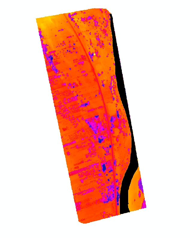
Dan,
Please see attached screenshoots representing DTM (values raging from 30 - 128), River (raster of constant value of 87) and DTM+River, hope that will help you understand the problem.
DTM
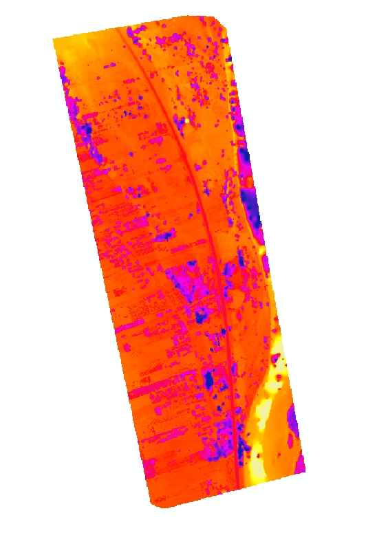
River

Output = DTM + River (values of DTM where DTM does not overlap River and River values (87) within River raster boundaries)
I have tried to use your syntax but got an error 000539: Runtime error SyntaxError: Keyword can't be an expression.
I'm not sure what have caused the problem. My guess it's the Syntax or the fact that River raster is strictly limited as shown on the above picture and doesn't have any nodata areas...
Still it's my guess, but I'm still unable to generate the output raster
Any suggestions much appreicated
Cheers,
Peter
- Mark as New
- Bookmark
- Subscribe
- Mute
- Subscribe to RSS Feed
- Permalink
Sorry Peter, trying to help without Arc* running.
Use the Con tool in arctoolbox. It may be a double equal sign ( == for the equality check), try not to type the expression, select your rasters, the equality check etc when constructing the Con statement. Also, in the Environments tab, set the combined extent of the rasters to be the union of the inputs (or that of the DTM), make sure that the cell size is the same. Save the resultant raster to a folder (temp or otherwise) for testing purposes.
If this doesn't work, I hope that someone with Arc* running will be able to wade in. Regards Dan