Turn on suggestions
Auto-suggest helps you quickly narrow down your search results by suggesting possible matches as you type.
Cancel
- Home
- :
- All Communities
- :
- Products
- :
- Data Management
- :
- Data Management Questions
- :
- Re: Doubt about my geo referencing procedure
Options
- Subscribe to RSS Feed
- Mark Topic as New
- Mark Topic as Read
- Float this Topic for Current User
- Bookmark
- Subscribe
- Mute
- Printer Friendly Page
05-07-2014
10:45 AM
- Mark as New
- Bookmark
- Subscribe
- Mute
- Subscribe to RSS Feed
- Permalink
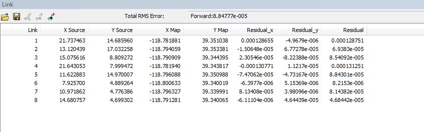
I just completed creating 8 links to rectify a 1948 aerial photo TIFF to 2013 NAIP imagery, using Arc 10.2 I'm skeptical of the Residual (RMS) error, which I use to judge how effective the links are. Please see the attached screen capture. I believe that the RMS error is in the units of the arc map session, in this case, Meters. Specifically, I'm skeptical of the 0000884777 Total RMS error. Does this look reasonable? I'm linking points on the 1948 TIFF to the same points that I've ID'd on the 2013 NAIP. Should I be linking: TIFF to Imagery? Alternatively, should I create some vector point features, overlaid on the 2013 NAIP, and then link: TIFF to point features?
Ken
Ken
Solved! Go to Solution.
1 Solution
Accepted Solutions
05-08-2014
06:50 AM
- Mark as New
- Bookmark
- Subscribe
- Mute
- Subscribe to RSS Feed
- Permalink
Hi Ken,
My rough approximation of degrees-to-meters is to say that the 4th decimal place is about 30m, so you're seeing a fit around 3 m or less.
If you can, it's sometimes better to georeference directly to the native coordinate system of the raster. Then reproject it if necessary. It's more necessary as scale gets smaller (larger area is represented).
Melita
16 Replies
05-07-2014
11:47 AM
- Mark as New
- Bookmark
- Subscribe
- Mute
- Subscribe to RSS Feed
- Permalink
RMS is in the units of the coordinate system which is, in this case, decimal degrees (your links are lat/lon).
Melita
Melita
05-07-2014
12:13 PM
- Mark as New
- Bookmark
- Subscribe
- Mute
- Subscribe to RSS Feed
- Permalink
Melita,
Thank you for responding. I realize the X & Y figures in the link table are lat & long. My doubt is about the total RMS error. Is that a reasonable RMS error to you (meters, in the map units)? I just tried creating point features on the NAIP imagery and then linked the 1948 tiff to those. 7 of these links resulted in a higher RMS error, although still well below 0.0 In geo referencing I've done before it required a lot of links to get just to a 0 RMS; course that work was with GIS 9.3
Ken
05-07-2014
01:21 PM
- Mark as New
- Bookmark
- Subscribe
- Mute
- Subscribe to RSS Feed
- Permalink
Perhaps I'm not understanding something. It's been a while since I georeferenced data. The total RMS values are in decimal degrees, because that's what the target links are in. If you want RMS in meters, you're going to have georeference to a map that's in a projected coordinate system or use links with target values in meters.
Melita
Melita
05-08-2014
05:51 AM
- Mark as New
- Bookmark
- Subscribe
- Mute
- Subscribe to RSS Feed
- Permalink
My original questions remain un answered. Is the RMS error, in the original attachment, realistic; does it tell me anything? Is it right to link pts in a tiff directly to a image raster? Can someone suggest how I might optimize the settings in the attached capture Rectify window? Please see attached.
Ken
Ken
05-08-2014
06:50 AM
- Mark as New
- Bookmark
- Subscribe
- Mute
- Subscribe to RSS Feed
- Permalink
Hi Ken,
My rough approximation of degrees-to-meters is to say that the 4th decimal place is about 30m, so you're seeing a fit around 3 m or less.
If you can, it's sometimes better to georeference directly to the native coordinate system of the raster. Then reproject it if necessary. It's more necessary as scale gets smaller (larger area is represented).
Melita
My rough approximation of degrees-to-meters is to say that the 4th decimal place is about 30m, so you're seeing a fit around 3 m or less.
If you can, it's sometimes better to georeference directly to the native coordinate system of the raster. Then reproject it if necessary. It's more necessary as scale gets smaller (larger area is represented).
Melita
05-08-2014
08:14 AM
- Mark as New
- Bookmark
- Subscribe
- Mute
- Subscribe to RSS Feed
- Permalink
Melita,
Your last note was key to helping me understand how I need to think of the RMS in terms of degrees error. I've tried, unsuccessfully, to reverse engineer your approx. math, where you came up with 3 meters of error: degrees to meters. Would you please tell me what is wrong with my conversion math:
1 degree = 111 kilometers. To convert our RMS error: (0.0000884777 * 111) * 1000m = 9.8 meters of error
Instead of re projecting the imagery, to gain more accuracy, can we not just change the arcmap session to the native projection, of the imagery, to eliminate the error as ArcMap projects the imagery on the fly?
Ken
05-08-2014
08:40 AM
- Mark as New
- Bookmark
- Subscribe
- Mute
- Subscribe to RSS Feed
- Permalink
My conversion comes from:
6378137 * 2 * PI / 360 = 111.319 km (length of a degree at the equator)
111.319 km / 3600 (seconds in a degree) = 30.922 m (length of a second at the equator)
1" = 2.7777777777777777777777777777778e-4 degrees = 0.000277 degrees
So you're closer!
Melita
6378137 * 2 * PI / 360 = 111.319 km (length of a degree at the equator)
111.319 km / 3600 (seconds in a degree) = 30.922 m (length of a second at the equator)
1" = 2.7777777777777777777777777777778e-4 degrees = 0.000277 degrees
So you're closer!
Melita
05-08-2014
09:33 AM
- Mark as New
- Bookmark
- Subscribe
- Mute
- Subscribe to RSS Feed
- Permalink
Melita,
It made my whole day to see your math in the last note! I was able to use it to arrive at my earlier calc, done with diff math, of
9.8m. It re assures, and makes sense, to me to get a realistic result, like 9.8 meters of error, for the tiff I geo referenced, instead of the really small number I misinterpreted. Thanks so much, Melita, from me and the other 3 gis analysts on our team, for helping us understand this process better. We have hundreds of historical tiffs to geo reference in the next year.
For the other folks following this discussion: let me try to sum up the process of interpreting the RMS error reported in the link table, using Melita's math :
determine that the figures under the X & Y map columns are lat and long coords The RMS error is then in decimal degrees.
Our RMS error * 3600 seconds = converts the decimal degrees figure to seconds. The RMS seconds * 30.922 = the error, in meters Of course, this is the error at the equator and should be converted to your lat, if you need the extra accuracy. I'll post a follow up thread, showing my RMS error corrected for my lat, after I figure out how to convert it.
I think the definition of the RMS error: the error between the coords of the link points set on the tiff and the coords of the link points set at the same position on the NAIP imagery. I hope someone will feel free to correct my definition, if I'm in error.
Ken
05-09-2014
11:18 PM
- Mark as New
- Bookmark
- Subscribe
- Mute
- Subscribe to RSS Feed
- Permalink
As a rough approximation (ie on a sphere), just multiply your distance at the equator by the Cosine of the Latitude of where the data is to get the actual distance.
And to further underline Melita's point, you should always georeference into the correct projected coordinate system of the data. Not directly into GCS.
Good luck,
Neil
And to further underline Melita's point, you should always georeference into the correct projected coordinate system of the data. Not directly into GCS.
Good luck,
Neil