- Home
- :
- All Communities
- :
- Products
- :
- Data Management
- :
- Data Management Questions
- :
- Divide Irregular Polygon into 730 parts
- Subscribe to RSS Feed
- Mark Topic as New
- Mark Topic as Read
- Float this Topic for Current User
- Bookmark
- Subscribe
- Mute
- Printer Friendly Page
- Mark as New
- Bookmark
- Subscribe
- Mute
- Subscribe to RSS Feed
- Permalink
Is there a utility or something that I could use to divide an irregularly shaped polygon into 730 pieces, preferably of equal area? For example, take any given state polygon in the US and divide it into 730 pieces.
Thank you!!
Solved! Go to Solution.
- Mark as New
- Bookmark
- Subscribe
- Mute
- Subscribe to RSS Feed
- Permalink
Yeah, I noticed this morning that my code didn't match what was here, so I updated it. When I ran the script, I got 100 grids, but it was 100 over the entire map instead of each polygon. Not sure if I set something up wrong or what? Thanks again for the help!
- Mark as New
- Bookmark
- Subscribe
- Mute
- Subscribe to RSS Feed
- Permalink
I think it might be because I was not clearing the "tempGrid" in between iterations. Try adding these line after specifying the location of the "tempGrid" (line 25):
  #delete tempGrid if exists:
  if arcpy.Exists(tempGrid):
    arcpy.Delete_management(tempGrid)
I've also edited my post above to reflect these changes.
- Mark as New
- Bookmark
- Subscribe
- Mute
- Subscribe to RSS Feed
- Permalink
Well Joshua, it's still just dividing up the entire map layer into 100 grids instead of each polygon in the layer. Not sure if I am doing something wrong on the setup...In looking at the code, is each polygon supposed to be in it's own layer?
- Mark as New
- Bookmark
- Subscribe
- Mute
- Subscribe to RSS Feed
- Permalink
Ohhh, I think I completely misunderstood you. I thought you made multiple layers (pointing to multiple shapefiles/FCs) in an MXD that you wanted to split into a given number of grids. It sounds like you actually want to take a single layer in an MXD and split it into multiple grids. Is this correct?
Do they have to be split into a specific number of grids or into a grids of a specific dimension?
- Mark as New
- Bookmark
- Subscribe
- Mute
- Subscribe to RSS Feed
- Permalink
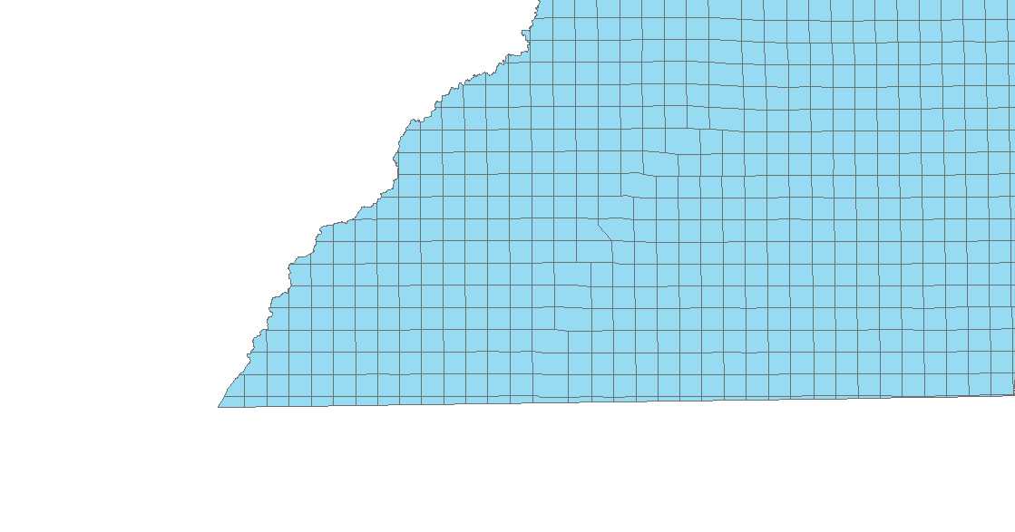
Sorry...I was afraid of that after I started looking closer at the code...Here is a sample of what I'm talking about. It is 1 layer with many polygons in a grid. I need to split each polygon into 100 sub-grids with number labels from 1-100. When I saw your original post, I liked the way the grids were laid out over the layer extents and thought it might work for my situation.
- Mark as New
- Bookmark
- Subscribe
- Mute
- Subscribe to RSS Feed
- Permalink
Hello Jack,
Thank you for the explanation and the picture. I think I now have a much better understanding of your needs. I've created another version of the script. Unfortunately I'm a little short on time and don't have time to test it. If you could let me know what errors pop up, we can fix the script as needed.
import arcpy
arcpy.env.overwriteOutput = True

#set feature classes:
inFC=r'C:\Path\To\Poly.shp'
tempGrid=r'C:\Path\To\tempGrid.shp' #just a temporary file
outFC=r'C:\Path\To\grid.shp' #final grid

#set number of desired cells:
x=100


#set ID field in the input feature class:
idField="ParentID" #set to a field you can use to identify with original record each grid was part of *MUST BE UNIQUE


#get shape field
shapeName = arcpy.Describe(inFC).shapeFieldName


#delete tempGrid if exists:
if arcpy.Exists(tempGrid):
  arcpy.Delete_management(tempGrid)
#delete outFC if exists:
if arcpy.Exists(outFC):
  arcpy.Delete_management(outFC)


#Create output FC (the where statement will select 0 records
arcpy.Select_analysis(inFC, outFC, '"'+idField+'" <> "'+idField+'"') #change double quotes "" to [] if using geodatabases


rows=arcpy.da.SearchCursor(idField,shapeName)
for row in rows:
  where='"'+idField+'" = \''+row.getValue(idField)+'\'' #change double quotes "" to [] if using geodatabases
  #Use this line if your idField is a number: where='"'+idField+'" = '+str(row.getValue(idField)) #change double quotes "" to [] if using geodatabases
  arcpy.MakeFeatureLayer_management(inFC, "master_lyr",where)
  feat = row.getValue(shapeName)

  #set default grid variables:
  extent = feat.extent
  origin_coord=str(extent.XMin)+" "+str(extent.YMin)
  oppositeCoorner=str(extent.XMax)+" "+str(extent.YMax)
  y_axis_coord=str(extent.XMin)+" "+str(extent.YMin+10)
  number_rows=number_columns=0
  geometryType = 'POLYGON'

  #set starting cellSize and increment:
  cellSize=max(float(extent.width),float(extent.height))
  inc=cellSize

  countOutFC=0.0 #needed to start while loop

  #Find an appropriate cell size:
  while countOutFC!=x:
    if cellSize==inc:
      inc=inc/2.0
      continue
    cell_width=cell_height=cellSize
    arcpy.CreateFishnet_management(tempGrid,origin_coord,y_axis_coord,cell_width,cell_height,number_rows,number_columns,oppositeCoorner,"LABELS","#",geometryType)

    arcpy.MakeFeatureLayer_management(tempGrid, "temp_lyr")
    arcpy.SelectLayerByLocation_management("temp_lyr", "INTERSECT", "master_lyr")

    countOutFC=float(arcpy.GetCount_management("temp_lyr").getOutput(0))

    print "Cell size: "+str(cellSize)+"  Count: "+str(countOutFC)
    if countOutFC>x:
      print "Overshot..."
      cellSize=prevCellSize
      inc=inc/2.0
    else:
      prevCellSize=cellSize
      cellSize-=inc

  cellSize=prevCellSize
  print '\nFound an appropriate cell size: '+str(cellSize)

  #Find a simplified cell size:
  print "\nTrying to simplify..."
  for i in range(len(str(cellSize))):
    simpCellSize=round(cellSize,i)
    if simpCellSize==0:
      continue
    cell_width=cell_height=simpCellSize
    arcpy.CreateFishnet_management(tempGrid,origin_coord,y_axis_coord,cell_width,cell_height,number_rows,number_columns,oppositeCoorner,"LABELS","#",geometryType)
    arcpy.MakeFeatureLayer_management(tempGrid, "temp_lyr")
    arcpy.SelectLayerByLocation_management("temp_lyr", "INTERSECT", "master_lyr")

    countOutFC=float(arcpy.GetCount_management("temp_lyr").getOutput(0))
    print "Cell size: "+str(simpCellSize)+"  Count: "+str(countOutFC)
    if countOutFC==x:
      break

  if simpCellSize==cellSize:
    print "Could not easily find a simplified cell size."
    #rerun for last good cellsize (not simplified):
    cell_width=cell_height=cellSize
    arcpy.CreateFishnet_management(tempGrid,origin_coord,y_axis_coord,cell_width,cell_height,number_rows,number_columns,oppositeCoorner,"LABELS","#",geometryType)
    arcpy.MakeFeatureLayer_management(tempGrid, "temp_lyr")
    arcpy.SelectLayerByLocation_management("temp_lyr", "INTERSECT", "master_lyr")
  else:
    print "A simplified cell size: "+str(simpCellSize)

  arcpy.Append_management("master_lyr",outFC)


del rows
print "Done!!!"
- Mark as New
- Bookmark
- Subscribe
- Mute
- Subscribe to RSS Feed
- Permalink
Hi Joshua, I am trying to use your script and I keep getting a runtime error on line 30. Also, I am new to python, what parts of the code do I need to change in order to so it works with my feature class.
- Mark as New
- Bookmark
- Subscribe
- Mute
- Subscribe to RSS Feed
- Permalink
I don't know if all the quote marks on that line line up properly, but the final character should be ), not <.
- Mark as New
- Bookmark
- Subscribe
- Mute
- Subscribe to RSS Feed
- Permalink
- « Previous
-
- 1
- 2
- Next »
- « Previous
-
- 1
- 2
- Next »