Turn on suggestions
Auto-suggest helps you quickly narrow down your search results by suggesting possible matches as you type.
Cancel
- Home
- :
- All Communities
- :
- Products
- :
- Data Management
- :
- Data Management Questions
- :
- difference between spatial index in describe_long ...
Options
- Subscribe to RSS Feed
- Mark Topic as New
- Mark Topic as Read
- Float this Topic for Current User
- Bookmark
- Subscribe
- Mute
- Printer Friendly Page
difference between spatial index in describe_long and properties in ArcCatalog
Subscribe
657
4
04-16-2012 12:00 PM
by
Anonymous User
Not applicable
04-16-2012
12:00 PM
- Mark as New
- Bookmark
- Subscribe
- Mute
- Subscribe to RSS Feed
- Permalink
- Report Inappropriate Content
ArcSDE: 9.3 sp 1
Oracle 10g
This is a spatial view, joining a featureclass to a geodatabase table within the same schema
created by sde command sdetable -o create_view
When I do a sdelayer -o describe_long, I see a spatial index grid
Layer Description ....: <None>
Table Owner ..........: GRID
Table Name ...........: US_JSECTIONS_EOG_VW
Spatial Column .......: SHAPE
Layer Id .............: 604
SRID .................: 3
Minimum Shape Id .....: 1
Offset ...............:
falsex: -180.000000
falsey: -90.000000
System Units .........: 5000000.000000
Z Offset..............: 0.000000
Z Units ..............: 1.000000
Measure Offset .......: <None>
Measure Units ........: <None>
XY Cluster Tolerance .: 0.0000004
Spatial Index ........:
parameter: SPIDX_GRID,GRID0=0.022,GRID1=0.132,GRID2=0.66,FULL
exist: Yes
array form: 0.022,0.132,0.66
Layer Envelope .......:
minx: -124.73172, miny: 24.54290
maxx: -80.03131, maxy: 49.38447
Entities .............: nac+
Layer Type ...........: Extended SQL Type
Creation Date ........: Wed Feb 2 09:54:37 2011
I/O Mode .............: NORMAL
Autolocking ..........: Enabled
Precision.............: High
User Privileges ......: SELECT
Coordinate System ....: GEOGCS["GCS_North_American_1927",DATUM["D_North_American_1927",SPHEROID["Clarke_1866",6378206.4,294.9786982]],PRIMEM["Greenwich",0.0],UNIT["Degree",0.0174532925199433]]
Layer Configuration ..: DEFAULTS
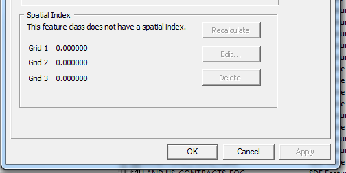
But when I look at the properties of the view in ArcCatalog, it's blank
[ATTACH=CONFIG]13556[/ATTACH]
Any ideas?
Oracle 10g
This is a spatial view, joining a featureclass to a geodatabase table within the same schema
created by sde command sdetable -o create_view
When I do a sdelayer -o describe_long, I see a spatial index grid
Layer Description ....: <None>
Table Owner ..........: GRID
Table Name ...........: US_JSECTIONS_EOG_VW
Spatial Column .......: SHAPE
Layer Id .............: 604
SRID .................: 3
Minimum Shape Id .....: 1
Offset ...............:
falsex: -180.000000
falsey: -90.000000
System Units .........: 5000000.000000
Z Offset..............: 0.000000
Z Units ..............: 1.000000
Measure Offset .......: <None>
Measure Units ........: <None>
XY Cluster Tolerance .: 0.0000004
Spatial Index ........:
parameter: SPIDX_GRID,GRID0=0.022,GRID1=0.132,GRID2=0.66,FULL
exist: Yes
array form: 0.022,0.132,0.66
Layer Envelope .......:
minx: -124.73172, miny: 24.54290
maxx: -80.03131, maxy: 49.38447
Entities .............: nac+
Layer Type ...........: Extended SQL Type
Creation Date ........: Wed Feb 2 09:54:37 2011
I/O Mode .............: NORMAL
Autolocking ..........: Enabled
Precision.............: High
User Privileges ......: SELECT
Coordinate System ....: GEOGCS["GCS_North_American_1927",DATUM["D_North_American_1927",SPHEROID["Clarke_1866",6378206.4,294.9786982]],PRIMEM["Greenwich",0.0],UNIT["Degree",0.0174532925199433]]
Layer Configuration ..: DEFAULTS
But when I look at the properties of the view in ArcCatalog, it's blank
[ATTACH=CONFIG]13556[/ATTACH]
Any ideas?
4 Replies
04-16-2012
01:32 PM
- Mark as New
- Bookmark
- Subscribe
- Mute
- Subscribe to RSS Feed
- Permalink
- Report Inappropriate Content
If it's a view, then the spatial index parameters of the base table are what matters --
does Catalog report those correctly?
I do question the wisdom of using three levels of spatial index. I've only seen one
table in the past fifteen years of SDE consulting which got a performance benefit
from three vs two indexing levels, and the overall performance was so bad, the
(very diiferent) data sources should really have been mapped to different tables.
- V
by
Anonymous User
Not applicable
04-16-2012
01:59 PM
- Mark as New
- Bookmark
- Subscribe
- Mute
- Subscribe to RSS Feed
- Permalink
- Report Inappropriate Content
Thanks for the reply Vince.
The underlying table is reporting the same spatial index grid as what is shown when I do a sdelayer -o describe_long.
The 3 levels of grid was created when I clicked the "recalculate" button so it wasn't a conscious choice by me or the company to have that. Should I delete level three after ArcCatalog recalculate the grid? The view is terribly slow which is why I thought it might be the spatial index to begin with.
by
Anonymous User
Not applicable
04-16-2012
02:15 PM
- Mark as New
- Bookmark
- Subscribe
- Mute
- Subscribe to RSS Feed
- Permalink
- Report Inappropriate Content
Vince,
You're a genius! I deleted level 3 grid and the view came back less than a second! It would take up to 35 seconds before. Thanks for the suggestion.
You're a genius! I deleted level 3 grid and the view came back less than a second! It would take up to 35 seconds before. Thanks for the suggestion.
06-08-2023
06:30 AM
- Mark as New
- Bookmark
- Subscribe
- Mute
- Subscribe to RSS Feed
- Permalink
- Report Inappropriate Content
Note for records: Original post and comments from 04-16-2012 04:59 PM and 04-16-2012 05:15 PM were produced by @tnarladni
Jesse Cloutier
Community Manager, Engagement & Content
Community Manager, Engagement & Content