Turn on suggestions
Auto-suggest helps you quickly narrow down your search results by suggesting possible matches as you type.
Cancel
- Home
- :
- All Communities
- :
- Products
- :
- Data Management
- :
- Data Management Questions
- :
- Re: DEM has 'grid' distortion to it, and makes the...
Options
- Subscribe to RSS Feed
- Mark Topic as New
- Mark Topic as Read
- Float this Topic for Current User
- Bookmark
- Subscribe
- Mute
- Printer Friendly Page
DEM has 'grid' distortion to it, and makes the calculated slope map for it unusable.
Subscribe
746
2
11-10-2012 12:43 AM
11-10-2012
12:43 AM
- Mark as New
- Bookmark
- Subscribe
- Mute
- Subscribe to RSS Feed
- Permalink
- Report Inappropriate Content
I'm sure this question has come up before, but I can't seem to find it. I'm not entirely sure what to search for.
I am using ArcGIS 10.0
[ATTACH=CONFIG]19197[/ATTACH]
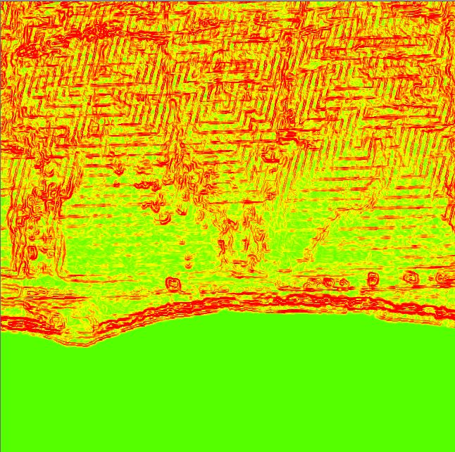
I have a DEM of a coastline. As you can see in the attached image, it has a grid overlay to it. If I understand correctly, this is because it was calculated via nearest neighbor? That's not so important since I don't have the original data, only the resulting DEM - the grid is annoying, but if I zoom in on any part of the grid the "line" shrinks, so it doesn't actually seem to impact any of the elevation data points. So I can live with it.
However!
When I create a slope map, these "infinitely thin" grid lines suddenly become quite large, and ruin the data. The second attached image should show what I'm dealing with (in this case, it's a curvature map). I'm using Spatial Analyst -> Surface -> Slope.
[ATTACH=CONFIG]19196[/ATTACH]
I have a hard time believing there isn't a workaround for this, but I just have no clue what it might be. If anyone could help me out, I would be almost infinitely grateful.
Regards,
David
I am using ArcGIS 10.0
[ATTACH=CONFIG]19197[/ATTACH]
I have a DEM of a coastline. As you can see in the attached image, it has a grid overlay to it. If I understand correctly, this is because it was calculated via nearest neighbor? That's not so important since I don't have the original data, only the resulting DEM - the grid is annoying, but if I zoom in on any part of the grid the "line" shrinks, so it doesn't actually seem to impact any of the elevation data points. So I can live with it.
However!
When I create a slope map, these "infinitely thin" grid lines suddenly become quite large, and ruin the data. The second attached image should show what I'm dealing with (in this case, it's a curvature map). I'm using Spatial Analyst -> Surface -> Slope.
[ATTACH=CONFIG]19196[/ATTACH]
I have a hard time believing there isn't a workaround for this, but I just have no clue what it might be. If anyone could help me out, I would be almost infinitely grateful.
Regards,
David
2 Replies
by
Anonymous User
Not applicable
11-12-2012
06:53 AM
- Mark as New
- Bookmark
- Subscribe
- Mute
- Subscribe to RSS Feed
- Permalink
- Report Inappropriate Content
Original User: erictrice
David,
Those lines are now "IN" the data. You are spot on regarding Nearest resampling. Sorry to bring bad news, but you need a different DEM if you can't get the original one before someone resampled it incorrectly. It most often is because someone projected the data and resampled it with defaults even though the resampling parameter specifically says don't use Nearest for surfaces such as elevation.
""The NEAREST and MAJORITY options are used for categorical data, such as a land-use classification. The NEAREST option is the default since it is the quickest and also because it will not change the cell values. Do not use NEAREST or MAJORITY for continuous data, such as elevation surfaces."
Best of luck,
Eric
11-12-2012
07:00 AM
- Mark as New
- Bookmark
- Subscribe
- Mute
- Subscribe to RSS Feed
- Permalink
- Report Inappropriate Content
Hi David,
I would try resampling the DEM using 'MAJORITY' resampling technique to see if that cleans up the areas affected by the GRID lines.
I would try resampling the DEM using 'MAJORITY' resampling technique to see if that cleans up the areas affected by the GRID lines.