Turn on suggestions
Auto-suggest helps you quickly narrow down your search results by suggesting possible matches as you type.
Cancel
- Home
- :
- All Communities
- :
- Products
- :
- Data Management
- :
- Data Management Questions
- :
- Data not aligning correctly
Options
- Subscribe to RSS Feed
- Mark Topic as New
- Mark Topic as Read
- Float this Topic for Current User
- Bookmark
- Subscribe
- Mute
- Printer Friendly Page
Data not aligning correctly
Subscribe
3192
7
11-07-2013 03:05 PM
11-07-2013
03:05 PM
- Mark as New
- Bookmark
- Subscribe
- Mute
- Subscribe to RSS Feed
- Permalink
Ok so I'm having an issue with a street segment data set. The data frame I'm working with and most of the data has this
NAD_1983_UTM_Zone_17N
Projection: Transverse_Mercator
false_easting: 500000.00000000
false_northing: 0.00000000
central_meridian: -81.00000000
scale_factor: 0.99960000
latitude_of_origin: 0.00000000
Linear Unit: Meter
Geographic Coordinate System: GCS_North_American_1983
Datum: D_North_American_1983
Prime Meridian: Greenwich
Angular Unit: Degree
Now this is what I want and am working with. The dataset that will not align has the same source box info.
Projected Coordinate System: NAD_1983_UTM_Zone_17N
Projection: Transverse_Mercator
false_easting: 500000.00000000
false_northing: 0.00000000
central_meridian: -81.00000000
scale_factor: 0.99960000
latitude_of_origin: 0.00000000
Linear Unit: Meter
Geographic Coordinate System: GCS_North_American_1983
Datum: D_North_American_1983
Prime Meridian: Greenwich
Angular Unit: Degree
Since these are both the same, what can I do to align them? Is this possibly an error that occurred from the place I got the data? Is there a way I could grab a few control points and just shift it over, and if so, what tool does that fall under.
7 Replies
11-08-2013
05:16 AM
- Mark as New
- Bookmark
- Subscribe
- Mute
- Subscribe to RSS Feed
- Permalink
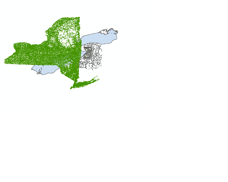
Looking at your image and datasets, The state of New York is almost entirely in UTM zone 18 North - I do not know why it would be saved as UTM zone 17 North, as the distortion would be high. Try making a copy and defining the coordinate system as UTM 18N and see how it aligns.
Regards,
Jim
Regards,
Jim
11-08-2013
11:02 AM
- Mark as New
- Bookmark
- Subscribe
- Mute
- Subscribe to RSS Feed
- Permalink
I'm trying to decide whether there's a size discrepancy. I can't figure out what the light blue data is supposed to represent! If there is a size discrepancy, the data that says it's using UTM 17N may really be in a UTM zone that's using feet, or a state plane zone in feet.
A trick is to identify which layer is definitely not in the right plane. Remove its coordinate system (set to unknown or 'clear' depending on ArcGIS version). Now add it to ArcMap with the other data. Set the data frame's coordinate system to other possibilities like UTM 18N, the various state plane zones, etc. If you can get the other data to line up with the 'unknown' one, you've just identified its coordinate system.
Post the extents of the datasets if you can't figure it out.
Melita
11-08-2013
12:47 PM
- Mark as New
- Bookmark
- Subscribe
- Mute
- Subscribe to RSS Feed
- Permalink
The light blue data is Lake Ontario, Melita. It really looks like a zone issue.
Regards.
Regards.
11-08-2013
01:15 PM
- Mark as New
- Bookmark
- Subscribe
- Mute
- Subscribe to RSS Feed
- Permalink
Now, I see it! Thanks, Jim!
Yes, ignore my answer, a bad UTM zone is much more likely.
Yes, ignore my answer, a bad UTM zone is much more likely.
11-12-2013
02:46 PM
- Mark as New
- Bookmark
- Subscribe
- Mute
- Subscribe to RSS Feed
- Permalink
Well the issue is Most of the data I have is in 17N because I'm working on a project for Erie County NRCS and Their data and the data I acquired from Erie county is in 17N as well. but I have a few data sets in 18N. The NRCS wants it in 17N to be compatible with other stuff they have, so I have to change the 18N and any state planes into 17N. I figured out the problem was that it said it was 17N but it really was 18. So my next step is to change it to 17 and hope it works out fine. if not, I'm going to do a spatial adjustment. I tried a spatial adjustment the other night and ARCGIS froze due to the massive workload it had to do. So I clipped a smaller area that I'm working in and am going to try that soon. I've just ran into some other problems now with merging multiple DEMS into 1 DEM.
11-12-2013
03:54 PM
- Mark as New
- Bookmark
- Subscribe
- Mute
- Subscribe to RSS Feed
- Permalink
I don't think you should have to do a spatial adjustment. Are you redefining the data as 17N using the Define Projection tool or the data's property page? Leave the 18N data defined as 18N, use the Project or Project Raster tools to convert it to 17N.
Melita
Melita
11-12-2013
04:59 PM
- Mark as New
- Bookmark
- Subscribe
- Mute
- Subscribe to RSS Feed
- Permalink
Ah, yes. I just figured it out about ten minutes before I saw this reply. It aligns nicely and I am progressing at the moment. Thank you. Any suggestions on the merging of multiple DEMS? I found the tool to do it in the help area of 10.1 but on my schools desktop version, that toolbar does not exist. The spatial analyst is on in environments and the toolbar is up and docked. but I still can't find the right tool.