Turn on suggestions
Auto-suggest helps you quickly narrow down your search results by suggesting possible matches as you type.
Cancel
- Home
- :
- All Communities
- :
- Products
- :
- Data Management
- :
- Data Management Questions
- :
- Creating a "pick list" (drop down menu) for a geod...
Options
- Subscribe to RSS Feed
- Mark Topic as New
- Mark Topic as Read
- Float this Topic for Current User
- Bookmark
- Subscribe
- Mute
- Printer Friendly Page
Creating a "pick list" (drop down menu) for a geodatabase
Subscribe
2339
11
02-15-2013 12:41 PM
02-15-2013
12:41 PM
- Mark as New
- Bookmark
- Subscribe
- Mute
- Subscribe to RSS Feed
- Permalink
- Report Inappropriate Content
Hello,
Just joined the forum, hoping someone can help me out. I'm attempting to create a pick list in ArcMap/Catalog and can't seem to get it down. I've created a geodatabase with coded domains (that I thought would generate a pick list but didn't), created a feature class within the geodatabase, exported to a shapefile, and placed that file into my mobile device (Juno hand held). The coded domains I create show up alright, but not with any pick list associated like I need. Any help/advice/links would be much appreciated.
Thanks!
11 Replies
02-18-2013
07:29 AM
- Mark as New
- Bookmark
- Subscribe
- Mute
- Subscribe to RSS Feed
- Permalink
- Report Inappropriate Content
Once you have associated the domain with the feature class you will get a drop down/pick list when editing in the geodatabase. You can associate the domain with the feature class by
1. Right clicking on the feature class and select properties
2. go to fields tab
3. select the field you want the domain for and look under field properties
4. you should see Domain, here you should be able to select the domain you want to use for this field
5. apply your changes and when you go to edit in arcMap you will have a pick list for that field.
With a shapefile however you can not set up a domain or pick lists and when you export to a shapefile you will lose that functionality but not that values you have already entered.
Depending on your software you are using on your juno hand held you may be able to set something up in that.
Hope that helps.
02-19-2013
08:39 AM
- Mark as New
- Bookmark
- Subscribe
- Mute
- Subscribe to RSS Feed
- Permalink
- Report Inappropriate Content
Thanks for the reply, I feel like I must be missing something obvious. Here's a step by step of what I'm doing, hopefully someone will see a misstep in my actions:
In ArcCatalog:
Create new File GeoDatabase and name. Open properties and enter the domain field. Enter "Species List" as Domain Name and under Domain Properties:
Field: Text
Domain Type: Coded Values
Split policy: Duplicate
Merge policy: Default
Then I enter a series of Codes and associated Descriptions. (Ii, iname; Kk, kname; mm, mname)
Apply.
Then I create a Feature Class with a name and alias, select "Point Features" and choose the Coord system and click Next until I get to the Field Name and Data Type table. There, I associate the feature class to the domain as described above and select Finish.
Now, I drop my feature class into ArcMap and open the attribute table in editor mode, but none of my coded domains show up. What am I missing?
02-19-2013
08:58 AM
- Mark as New
- Bookmark
- Subscribe
- Mute
- Subscribe to RSS Feed
- Permalink
- Report Inappropriate Content
Then I create a Feature Class with a name and alias, select "Point Features" and choose the Coord system and click Next until I get to the Field Name and Data Type table. There, I associate the feature class to the domain as described above and select Finish.
When you created the featureclass, what data type did you give the field that you are using for the domain? Integer? or Text?
The field you are using for the domain should have been created as a Long Integer, because you are storing integer values in place of the actual text in the domain.
02-19-2013
09:02 AM
- Mark as New
- Bookmark
- Subscribe
- Mute
- Subscribe to RSS Feed
- Permalink
- Report Inappropriate Content
Under Data Type I selected "Text"
02-19-2013
09:07 AM
- Mark as New
- Bookmark
- Subscribe
- Mute
- Subscribe to RSS Feed
- Permalink
- Report Inappropriate Content
The field you are using for the domain should have been created as a Long Integer, because you are storing integer values in place of the actual text in the domain.
02-19-2013
09:27 AM
- Mark as New
- Bookmark
- Subscribe
- Mute
- Subscribe to RSS Feed
- Permalink
- Report Inappropriate Content
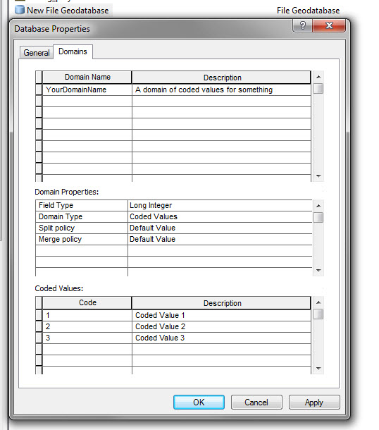
Example.
If you created a coded value domain with long integer values, then the field in the featureclass also needs to be a long integer data type.
[ATTACH=CONFIG]21959[/ATTACH]
"Coded Value 1", "Coded Value 2".. etc will be the values in your pick list.
Always start your values with "1", because if you use "0", and export this featureclass to a shapefile, shapefiles will default to 0 for features that did not get a coded value, so you won't know the difference between the 0 for something and the default 0 a shapefile gets.
02-19-2013
09:42 AM
- Mark as New
- Bookmark
- Subscribe
- Mute
- Subscribe to RSS Feed
- Permalink
- Report Inappropriate Content
Alright!!! If I could reach through the internet and hug you I would. Now, the final cog here seems to be moving these files to my Juno device...looks like feature classes are set as LOCK files and are unable to be moved. Is there an easy way to get around that?
02-19-2013
09:46 AM
- Mark as New
- Bookmark
- Subscribe
- Mute
- Subscribe to RSS Feed
- Permalink
- Report Inappropriate Content
you can just mark my reply as helpful or answered, that would work.
Your featureclasses are locked? Do you have them open in another mxd, or another instance of ArcCatalog?
Your featureclasses are locked? Do you have them open in another mxd, or another instance of ArcCatalog?
02-19-2013
11:22 AM
- Mark as New
- Bookmark
- Subscribe
- Mute
- Subscribe to RSS Feed
- Permalink
- Report Inappropriate Content
Ah, yes, when I close Catalog the LOCK file disappears. The featureclass doesn't seem to be something I can move into the Juno, or at least I can't see the file to move since it disappears when I close Catalog. I can export the featureclass to a shapefile and move it from my C:Drive to the Juno but it doesn't retain the ability to act as a pick-list as a shapefile.
Sorry to bombard this thread with questions, I'm a complete noob to this side of GIS.
Sorry to bombard this thread with questions, I'm a complete noob to this side of GIS.