- Home
- :
- All Communities
- :
- Products
- :
- Data Management
- :
- Data Management Questions
- :
- Change the reverse geocoding for composite geocode...
- Subscribe to RSS Feed
- Mark Topic as New
- Mark Topic as Read
- Float this Topic for Current User
- Bookmark
- Subscribe
- Mute
- Printer Friendly Page
Change the reverse geocoding for composite geocoder
- Mark as New
- Bookmark
- Subscribe
- Mute
- Subscribe to RSS Feed
- Permalink
- Report Inappropriate Content
I have a geocoding service that capable to do reverse geocoding. the source locator is a composite locator which consist of 4 locators to work for postal code to return polygon, address locator return address and city locator to return a city point etc. now when it receives x and y value for reverse geocoding, application is supposed to use address locator first and try to search for a specific address, but now is just always use postal code locator and return a postal code string.
I wonder anyone knows how to change the settings to use address locator first if there is a specific address available to return, if the point does not fall into a urban area and no specific address available then use postal code locator and returns a postal code in this case?
Can anyone help?
I appreciate any replies.
Dave
- Mark as New
- Bookmark
- Subscribe
- Mute
- Subscribe to RSS Feed
- Permalink
- Report Inappropriate Content
Reverse geocoding will return 1 result only. Try changing your search distance
- Mark as New
- Bookmark
- Subscribe
- Mute
- Subscribe to RSS Feed
- Permalink
- Report Inappropriate Content
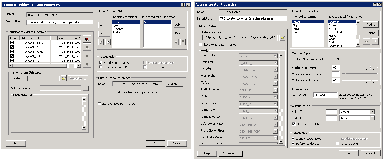
Thank you for your reply. This sound like could possible help. I want to try that but I don't know where I can change the search distance. Could you help me out. see the attached screen capture. The left is composite locator that includes 5 locators, first one is address locator used to work for specific address and second one is postal code locator when first locator does not find right candidate then try the second one for postal code (I assume the the order I added them in the left dialog should be the order that locator being tried, same for the reverse geocoding, I wonder is this right?)
I appreciate your help.
- Mark as New
- Bookmark
- Subscribe
- Mute
- Subscribe to RSS Feed
- Permalink
- Report Inappropriate Content
I was assuming you were using a service which allows you to specify search distance. Unless you can find it in the lot.xml file that you used to create the locator I'm not sure where you would go. Try reverse geocoding with only your address locator and then with the other locator and see which one returns the closest result.
ArcMap tends to do a lot behind the scenes.