- Home
- :
- All Communities
- :
- Products
- :
- Data Management
- :
- Data Management Questions
- :
- Re: Boundaries of merged\split fabric parcels stil...
- Subscribe to RSS Feed
- Mark Topic as New
- Mark Topic as Read
- Float this Topic for Current User
- Bookmark
- Subscribe
- Mute
- Printer Friendly Page
Boundaries of merged\split fabric parcels still appear when choosing “no fill” symbology,
- Mark as New
- Bookmark
- Subscribe
- Mute
- Subscribe to RSS Feed
- Permalink
- Report Inappropriate Content
Boundaries of merged\split fabric parcels still appear when choosing “no fill” symbology,
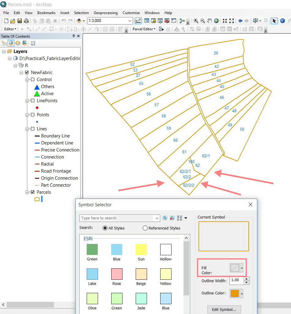
I wanted to represent the fabric layer with no fill. This appears to show the boundaries of parcles that have been already merged\split. I return, if the fabric layer is represented with fill symbology, then these boundaries get hidden.
How can I still represent the fabric layer with no fill while having the merged\split hidden?
Thank you
Best
Jamal
Jamal Numan
Geomolg Geoportal for Spatial Information
Ramallah, West Bank, Palestine
- Mark as New
- Bookmark
- Subscribe
- Mute
- Subscribe to RSS Feed
- Permalink
- Report Inappropriate Content
You still have an outline. Can't you set the outline to 0 or make the color the same as the fill
- Mark as New
- Bookmark
- Subscribe
- Mute
- Subscribe to RSS Feed
- Permalink
- Report Inappropriate Content
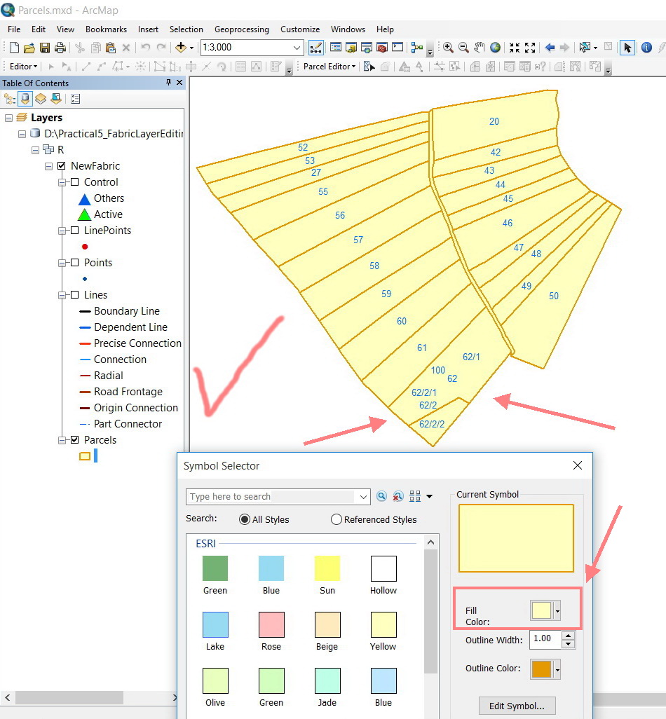
My question here is why the boundaries of merged\split fabric parcels disappear in case of “fill” and appears again in case of “no fill” option.
Be aware that this behavior is limited to the FABRIC LAYERS, I guess!
Jamal Numan
Geomolg Geoportal for Spatial Information
Ramallah, West Bank, Palestine
- Mark as New
- Bookmark
- Subscribe
- Mute
- Subscribe to RSS Feed
- Permalink
- Report Inappropriate Content
because the boundaries are still there when fill is on...you just can't see them unless they are in a substantially different color
- Mark as New
- Bookmark
- Subscribe
- Mute
- Subscribe to RSS Feed
- Permalink
- Report Inappropriate Content
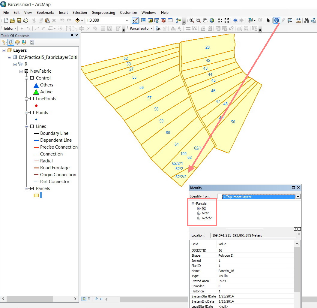
To me it look like there could be 3 parcels 62,62/2,62/2/2 are all in one parcel if that is what you meant ?
- Mark as New
- Bookmark
- Subscribe
- Mute
- Subscribe to RSS Feed
- Permalink
- Report Inappropriate Content
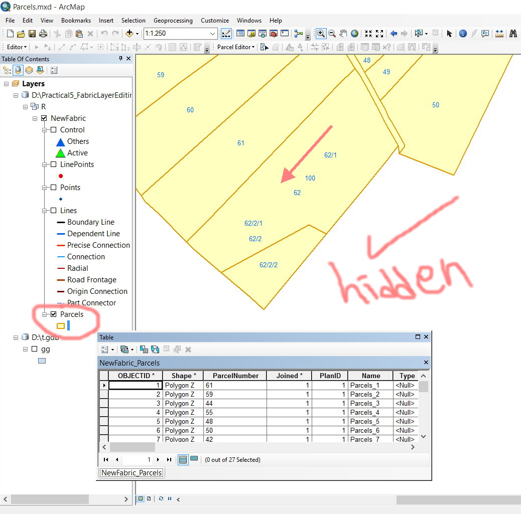
Thanks Robert. This is precisely what I mean.
I still need to have the symbology for the parcels “without fill” but having the indicated boundary below in the screenshot hidden.
What is interesting is that the indicated boundary below can be AUTOMATICALLY hidden if the symbology for the parcels is chosen to be “with fill”!
What might this indicate for?
Jamal Numan
Geomolg Geoportal for Spatial Information
Ramallah, West Bank, Palestine
- Mark as New
- Bookmark
- Subscribe
- Mute
- Subscribe to RSS Feed
- Permalink
- Report Inappropriate Content
is one feature stacked over the other? select the appropriate record in the table rather than onscreen and set your polygon outlines to 0
- Mark as New
- Bookmark
- Subscribe
- Mute
- Subscribe to RSS Feed
- Permalink
- Report Inappropriate Content
Hi Dan,
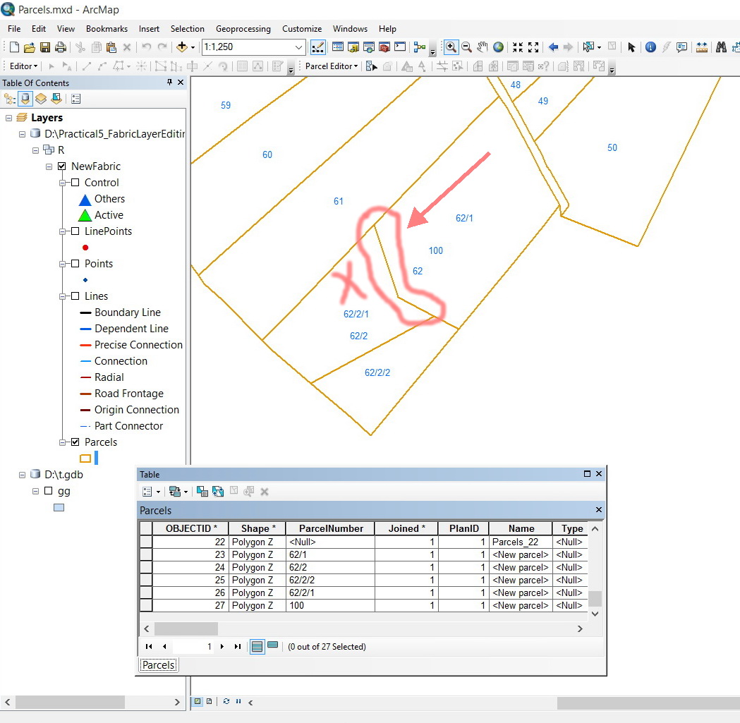
I think that the behavior with the fabric feature class is different from the standard feature class. You may need to try it in an actual fabric environment.
Please, find attached my fabric feature class
Jamal Numan
Geomolg Geoportal for Spatial Information
Ramallah, West Bank, Palestine
- Mark as New
- Bookmark
- Subscribe
- Mute
- Subscribe to RSS Feed
- Permalink
- Report Inappropriate Content
Have you contacted the Fabric group? you seem to be the only one ... other than the occasional esri member.... that uses them. The question remains as to whether the geometry is stacked as in a union or whether a symmetrical difference is produced. If it is to maintain historic lineage, then I wouldn't be surprised at all that the boundaries are retained and 'visually' they appear incorrect, however, in terms of attributes or temporal lineage they are.
- Mark as New
- Bookmark
- Subscribe
- Mute
- Subscribe to RSS Feed
- Permalink
- Report Inappropriate Content
Thanks Dan,
I’m not sure if your time has allowed you to explore the ready fabric feature class I have already provided. Trying to apply symbology will not yield results as working with regular feature classes
Jamal Numan
Geomolg Geoportal for Spatial Information
Ramallah, West Bank, Palestine