- Home
- :
- All Communities
- :
- Products
- :
- Data Management
- :
- Data Management Questions
- :
- after processing an image in ERDAS, ArcMAP do not ...
- Subscribe to RSS Feed
- Mark Topic as New
- Mark Topic as Read
- Float this Topic for Current User
- Bookmark
- Subscribe
- Mute
- Printer Friendly Page
after processing an image in ERDAS, ArcMAP do not respect the projection.
- Mark as New
- Bookmark
- Subscribe
- Mute
- Subscribe to RSS Feed
- Permalink
- Report Inappropriate Content
Hello,
1) I used GIS online services from NOAA (https://storms.ngs.noaa.gov/storms/maria/index.html#7/18.056/-64.824) to georeference an image in ArcMap.
2) In ArcMap I exported the file to produce an .img. I subsetted this image to send the "raw" data to Hexagon. In ArcMap the Current Coordinate System reads (WGS_1984_Web_Mercator_Auxiliary_Sphere; WKID: 3857 Authority: EPSG; Projection: Mercator_Auxiliary_Sphere: False_Easting: 0.0, False_Northing: 0.0, Central_Meridian: 0.0, Standard_Parallel_1: 0.0, Auxiliary_Sphere_Type: 0.0, Linear Unit: Meter (1.0).
3) I opened the .img file in Erdas Imagine and this software assigned the Pseudo Mercator projection with an EPSG 3857.
4) I processed the .img in Erdas Imagine to calculate the gndvi. In ArcMap when I look into the current Coordinate System it reads (Pseudo_Mercator; Authority: Custom; Projection: Stereographic_North_Pole: false_easting: 0.0; false_northing: 0.0; central_meridian: 0.0; standard_parallel_1: 0.0; Linear Unit: Meter (1.0); Geographic Coordinate System: GCS_WGS_1984
If you go to spatial reference
(https://spatialreference.org/ref/sr-org/epsg3857-wgs84-web-mercator-auxiliary-sphere/)
Web Mercator Projection
(https://en.wikipedia.org/wiki/Web_Mercator_projection)
My problem is when I add my original image to ArcMAP it opens fine, but after i add the image processed in Erdas image it do not align with the other and is too far and is turn around. How can I fix it? i am using arcmap 10.7.1
Hexagon is telling me
"We are continuing to explore this issue, but we think that ArcMap could be lacking an entry in their projection equivalency tables. Everyone calls “standard” projections by different names, which is why using EPSG codes are becoming popular. ERDAS IMAGINE and Esri ArcMap may support the exact same projection, but we call it Bill and they call it Terry. In ERDAS IMAGINE we have an equivalency table which says that if you see Terry, treat it as Bill. But ArcMap may not have an equivalency saying what to do if they see Bill, so when Bill occurs they don’t know what to do with it."
Regards,
Diego Llamas
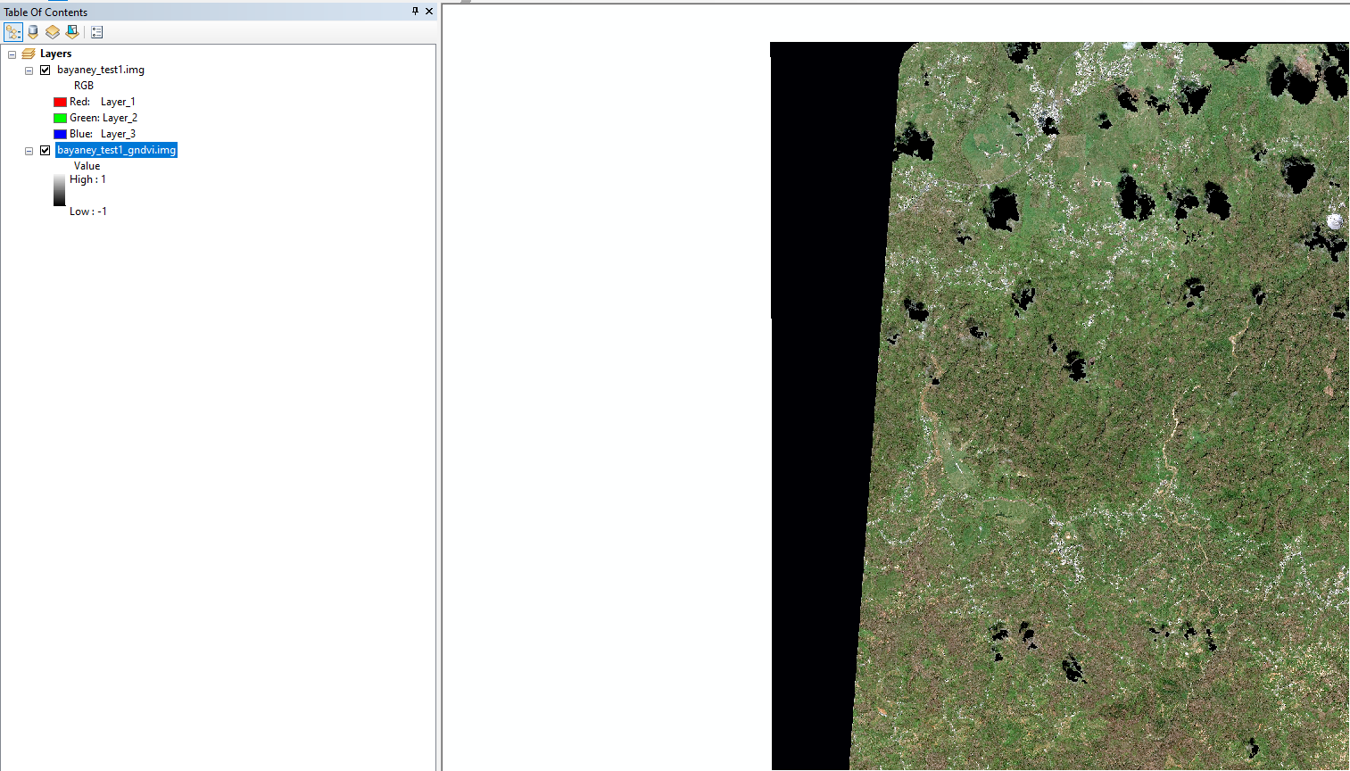
original image
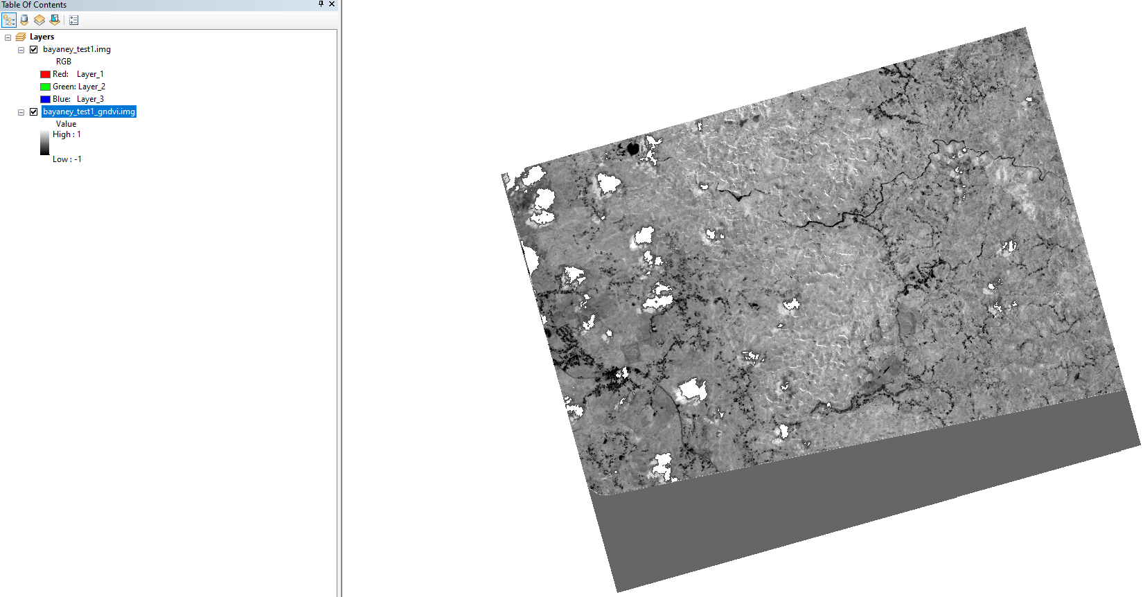
erdas image