- Home
- :
- All Communities
- :
- Products
- :
- Data Management
- :
- Data Management Questions
- :
- Re: Active X, issues with "Add Geometry" too;
- Subscribe to RSS Feed
- Mark Topic as New
- Mark Topic as Read
- Float this Topic for Current User
- Bookmark
- Subscribe
- Mute
- Printer Friendly Page
- Mark as New
- Bookmark
- Subscribe
- Mute
- Subscribe to RSS Feed
- Permalink
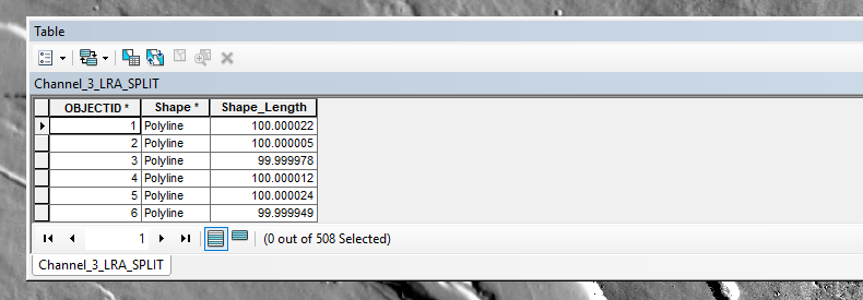
I have been using the Add Geometry ARCGIS tool to add geometric data to records in a shape file of small of polylines. These small equal length polylines are the consequence of splitting a larger polyline. The Fluvial Corridor Centre line tool produces this larger polyline.
I have just upgraded my system to ARCGIS 10.5.1 and Win 10 on a Mac and for all intents and purposes appears to be performing as required with the exception that Add Geometry does not work. The tool stops with the errors shown when using shape files of polylines produced derived from this upgrade.
My previous system Win 7 + ARC 10.3+Mac worked reasonably well with the Add Geometry tool but became more likely to fail in a similar manner just prior to upgrade. I attributed this to lack of storage (the reason for upgrade)
With shape files from the previous system build I have set all geometric data derived by ADD Geometry to zero by using the field calculator in each table column. Those shape files which worked before still work with Add Geometry and those shape files that did not work with Add Geometry still fail to do so.
Both shape files are in the Map default gdb and these are attached labled work_shapefile and not_working_shapefile. The working_shapefile fields containing geometrical information have been set to zero.
The main difference between the two is the working shapefile/feature has an FID but the shapefile / feature that fails has an OBJECTID. I have tried to change the OBJECTID to FID using feature copy, there is no change. However as I understand it this difference should not matter.
Solved! Go to Solution.
Accepted Solutions
- Mark as New
- Bookmark
- Subscribe
- Mute
- Subscribe to RSS Feed
- Permalink
Narrowed the issue down to a third party tool which was only qualified to ARCGIS 10.3.1
- Mark as New
- Bookmark
- Subscribe
- Mute
- Subscribe to RSS Feed
- Permalink
ActiveX issues ...??? see the answer in that link.
- Mark as New
- Bookmark
- Subscribe
- Mute
- Subscribe to RSS Feed
- Permalink
Thankyou
- Mark as New
- Bookmark
- Subscribe
- Mute
- Subscribe to RSS Feed
- Permalink
I have worked further on this and not progressed (the data is all in the gdb) & I have tried:
- different names
- I have successfully used other features / feature copy/ editors; split line at point
- I am using a shape file (OID) with this function and have used feature/feature copy and not realised an FID however I don't think that should matter(?)
- I have taken a copy of a previously successful Add Geometry ( this has FID & OID) and deleted the table data and re run Add Geometry and it has failed
It is odd that other tools seem to work except for this one -- I realise I might be missing the blindingly obvious, any suggestions most welcome.
I don't know if this a gbd issue as everything else seems to be OK or it could be the tool
- Mark as New
- Bookmark
- Subscribe
- Mute
- Subscribe to RSS Feed
- Permalink
the ActiveX issue was something that appeared with one of the Windows 10 upgrades... do you get the warning when you open up any other arctoolbox tool and click in one of the input lines? The geometry issue and the active x issues may not be related.
Also, you just don't delete a featureclass table... do you mean you deleted some columns? If it is in a geodatabase, then you should have an OBJECTID field. FID is the shapefile equivalent, and OID is the 3rd field needed apparently in a shapefile (basically it is just along for the ride)
- Mark as New
- Bookmark
- Subscribe
- Mute
- Subscribe to RSS Feed
- Permalink
Dan, I have restated the issue and added an example of the working and non working examples of the shapefiles/features
- Mark as New
- Bookmark
- Subscribe
- Mute
- Subscribe to RSS Feed
- Permalink
Your suggestion addressed the Active X problem thank you and the Active X and geometry issues seem to be unrelated as you suggest. Both features have their own feature class in the default gdb. Is it common that you can have either a FID or an OBJECTID in a table when both features have been created in the same data base?
- Mark as New
- Bookmark
- Subscribe
- Mute
- Subscribe to RSS Feed
- Permalink
FID, in my experience, is from a shapefile, so perhaps if a shapefile was brought into a geodatabase featureclass the FID would be retained, but the OBJECTID would be the new field used to serve as the geometry key. Since I have never 'mixed' shapefiles with geodatabases... that would be a test for you to do. If the FID field exists within the geodatabase fields, its field properties would probably not identify it as required (you could check that directly).
I have never created a geodatabase featureclass or table and had a FID field appear, not once, in either ArcMap or Pro... I suspect that its presence is the result of an import or a manual creation
Glad the Active-X is fixed at least
- Mark as New
- Bookmark
- Subscribe
- Mute
- Subscribe to RSS Feed
- Permalink
Thanks for the info. When I review how I have created what I presently have it has not been designed but organically grown as I learned so I have made some mistakes I am sure. When I migrated to my new HW config I installed SQL server Express 2014 ( ARC 10.5.1), but when I migrated my data I took the instance of my ARC 10.3.1 gdb and copied it to MyDocs/ARC on my new build. Most of the tools work except for Add Geometry work. Additionally when I started I stored some shape-files external to the gdb on an attached drive because I was strapped for local disk storage so that is probably why I have a mix. It's ironic that the feature containing the FID works and the feature with the OBJECTID doesn't. I think now is the time to get my act together and try and sort this out and rebuild the gdb. There are various forms of export available in ARC, I need to copy the data which will come from the default gdb and the data files external to it but get the gdb to re-establish the rules and control necessary for stable operation. During export would the internal / external aspect of the data be lost and the resultant data package be presented as a complete gdb or would I have to manually import external data into the gdb. The latter approach could create its own problems as I would be writing to a 10.3 instance of the data base with access tools from 10.5?
- Mark as New
- Bookmark
- Subscribe
- Mute
- Subscribe to RSS Feed
- Permalink
Narrowed the issue down to a third party tool which was only qualified to ARCGIS 10.3.1