- Home
- :
- All Communities
- :
- User Groups
- :
- Coordinate Reference Systems
- :
- Questions
- :
- Re: Transformation from GRS_1980 to OGSB_1936
- Subscribe to RSS Feed
- Mark Topic as New
- Mark Topic as Read
- Float this Topic for Current User
- Bookmark
- Subscribe
- Mute
- Printer Friendly Page
Transformation from GRS_1980 to OGSB_1936
- Mark as New
- Bookmark
- Subscribe
- Mute
- Subscribe to RSS Feed
- Permalink
- Report Inappropriate Content
Hi, I'm attempting a transformation between these two coordinate systems. I've tried by adding the GRS_1980 raster then selecting Transformations > Using, however the only option is <custom> New Geographic Transformation. I used this method then tried to clip the GRS_1980 raster to the OGSB_1936 however I dont think it has worked correctly as the GRS raster doesnt align and overlay properly with the OGSB raster. Anyone have any advice, some details on the datasets below.
GRS_1980:
Spatial coverage: Europe
Pixel size: 500m
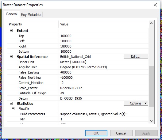
OGSB_1936:
Digital Elevation Model of area in southern England
Pixel size:50
- Mark as New
- Bookmark
- Subscribe
- Mute
- Subscribe to RSS Feed
- Permalink
- Report Inappropriate Content
OSGB data is here:
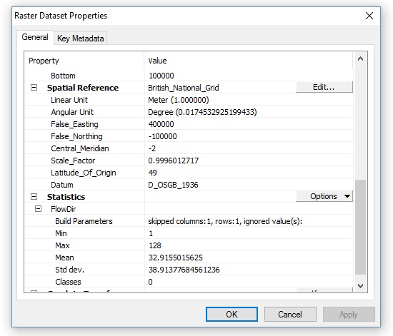
I've already succesfully used the OSGB to ETRS_1989 transformation on this data: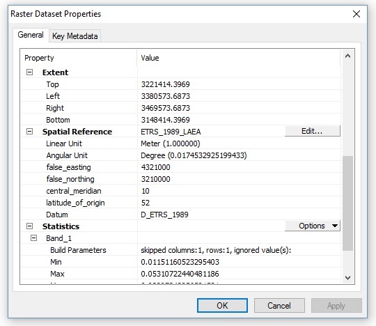
- Mark as New
- Bookmark
- Subscribe
- Mute
- Subscribe to RSS Feed
- Permalink
- Report Inappropriate Content
Note: I have been clipping (Data Management > Clip) the GRS_1980 data to the OSGB data prior to attempting any transfomations.
- Mark as New
- Bookmark
- Subscribe
- Mute
- Subscribe to RSS Feed
- Permalink
- Report Inappropriate Content
And what are the details of your clip polygon?
See that error there - about empty geometry.
I think that the underlying raster and your clip geometry are not in the same coordinate system.
- Mark as New
- Bookmark
- Subscribe
- Mute
- Subscribe to RSS Feed
- Permalink
- Report Inappropriate Content
Clip raster is here:
- Mark as New
- Bookmark
- Subscribe
- Mute
- Subscribe to RSS Feed
- Permalink
- Report Inappropriate Content
Then I still think you have messed up the coordinate system of the Lambert data.
I think it should look like this :

Note, this is the same parameters as your original, but the GCS is specified as WGS84
- Mark as New
- Bookmark
- Subscribe
- Mute
- Subscribe to RSS Feed
- Permalink
- Report Inappropriate Content
I agree with Neil. On your step when you change the coordinate system, rather than selecting the geographic coordinate system folder, right click the name of the current coordinate system, GRS_1980_IUGG_1980_Lambert_Azimuthal_Equal_Area, and select modify. That will open the dialog that I showed earlier. On that dialog, click the geographic coordinate system button on the lower right side. That will leave the Lambert azimuthal projection and parameters alone.
- « Previous
- Next »
- « Previous
- Next »