- Home
- :
- All Communities
- :
- User Groups
- :
- Coordinate Reference Systems
- :
- Questions
- :
- Re: Transformation from GRS_1980 to OGSB_1936
- Subscribe to RSS Feed
- Mark Topic as New
- Mark Topic as Read
- Float this Topic for Current User
- Bookmark
- Subscribe
- Mute
- Printer Friendly Page
Transformation from GRS_1980 to OGSB_1936
- Mark as New
- Bookmark
- Subscribe
- Mute
- Subscribe to RSS Feed
- Permalink
- Report Inappropriate Content
Hi, I'm attempting a transformation between these two coordinate systems. I've tried by adding the GRS_1980 raster then selecting Transformations > Using, however the only option is <custom> New Geographic Transformation. I used this method then tried to clip the GRS_1980 raster to the OGSB_1936 however I dont think it has worked correctly as the GRS raster doesnt align and overlay properly with the OGSB raster. Anyone have any advice, some details on the datasets below.
GRS_1980:
Spatial coverage: Europe
Pixel size: 500m
OGSB_1936:
Digital Elevation Model of area in southern England
Pixel size:50
- Mark as New
- Bookmark
- Subscribe
- Mute
- Subscribe to RSS Feed
- Permalink
- Report Inappropriate Content
Hi thanks for the reply, I redfined the raster to ETRS 1989 (Data Management > Define Projection), I then tried Project Raster using the following:
Output coordinate system: OSGB 1936
Geographic transformation: OSGB_1936_To_ETRS_1989_1
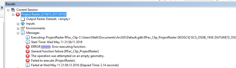
However i get the error
"ERROR 999999: Error executing function.
General function failure [Rf_ProjectRaster]
The operation was attempted on an empty geometry.
Failed to execute (ProjectRaster)."
Im using ArcMap 10.3.1, the raster also dissappears once i've defined the projection as ETRS 1989. Just to clarify the raster Spatial Reference is defined as GRS_1980_IUGG_1980_Lambert_Azimuthal_Equal_Area.
Thanks.
- Mark as New
- Bookmark
- Subscribe
- Mute
- Subscribe to RSS Feed
- Permalink
- Report Inappropriate Content
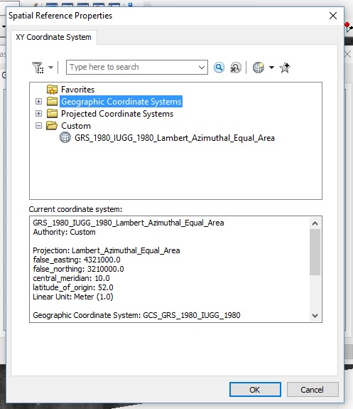
Ack, sorry about that. When you redefined the spatial reference/coordinate system, you should change only the geographic coordinate system portion. Keep the Lambert azimuthal definition as it is.
Melita
- Mark as New
- Bookmark
- Subscribe
- Mute
- Subscribe to RSS Feed
- Permalink
- Report Inappropriate Content
Sorry i'm not following there, what should I do differently? Thanks
- Mark as New
- Bookmark
- Subscribe
- Mute
- Subscribe to RSS Feed
- Permalink
- Report Inappropriate Content
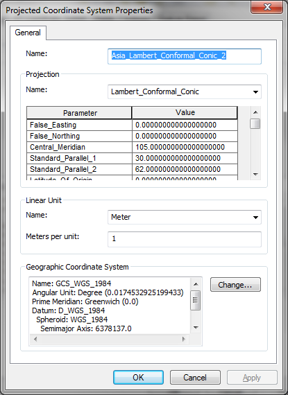
What Melita is saying that that you should have only changed the underlying GCS of your existing coordinate system,
scoot down using the arrow to the bottom half of the edit window. (picture 2 below).
- Mark as New
- Bookmark
- Subscribe
- Mute
- Subscribe to RSS Feed
- Permalink
- Report Inappropriate Content
When you go to edit the coordinate system (spatial reference), on the bottom half of the projected coordinate system dialog, you can click the Change button to edit just the geographic coordinate system.
- Mark as New
- Bookmark
- Subscribe
- Mute
- Subscribe to RSS Feed
- Permalink
- Report Inappropriate Content
Hi, I changed the Geographic Coordinate System to ETRS 1989 using this dialog, however i'm still getting the same error when I use Project Raster.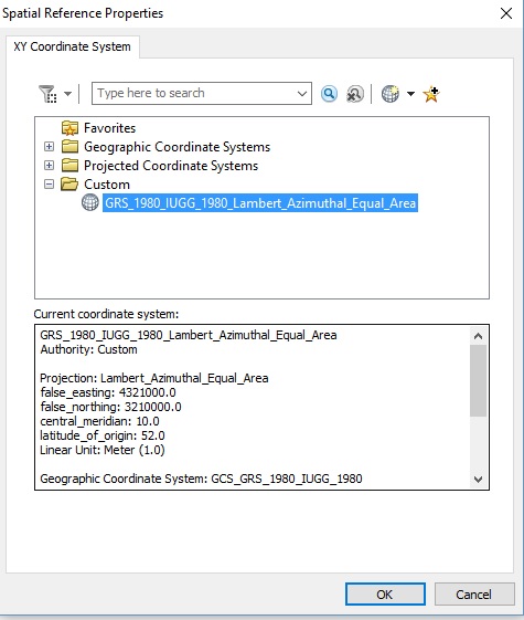
- Mark as New
- Bookmark
- Subscribe
- Mute
- Subscribe to RSS Feed
- Permalink
- Report Inappropriate Content
What was the coordinate system for your original GRS80 based data?
If you messed it up before reset it back to the original (or get the data again).
Then in Catalog, look at the coordinate system tab on the properties page.
There you should be able to modify this coordinate system. But only change the GCS part.
From GRS 80 to WGS84. Then and only then will you have a transformation available between OGSB and WGS when you do the project.
- Mark as New
- Bookmark
- Subscribe
- Mute
- Subscribe to RSS Feed
- Permalink
- Report Inappropriate Content
And, how closely are you expecting these 2 datasets to align anyway. The one has 500m pixels the other 50m...???
- Mark as New
- Bookmark
- Subscribe
- Mute
- Subscribe to RSS Feed
- Permalink
- Report Inappropriate Content
This is the original data:
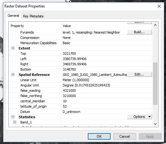
Following what you said Neil I changed the GCS to WGS 84 through this dialog:
Then I used Project Raster > OSGB to WGS84:
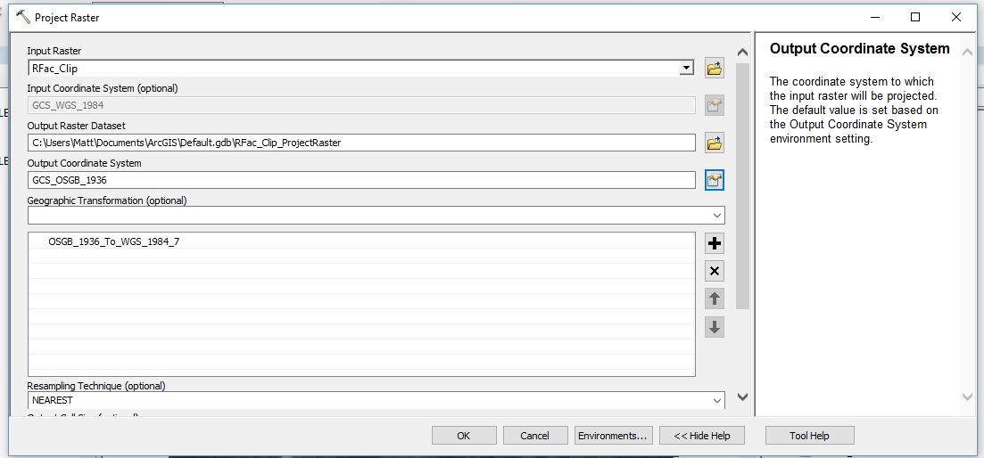
However i'm still getting this error:
Thanks for the help
- Mark as New
- Bookmark
- Subscribe
- Mute
- Subscribe to RSS Feed
- Permalink
- Report Inappropriate Content
Can you show us the extent of that OSBG raster. Also on the layer properties.