- Home
- :
- All Communities
- :
- User Groups
- :
- Coordinate Reference Systems
- :
- Questions
- :
- Re: Scale bar inaccurate on a projected geo-refere...
- Subscribe to RSS Feed
- Mark Topic as New
- Mark Topic as Read
- Float this Topic for Current User
- Bookmark
- Subscribe
- Mute
- Printer Friendly Page
Scale bar inaccurate on a projected geo-referenced map image, why?
- Mark as New
- Bookmark
- Subscribe
- Mute
- Subscribe to RSS Feed
- Permalink
- Report Inappropriate Content
I want to geo-reference a series of map, digitize features using polygons, and calculate accurate area measurements. I encountered the following issue:
After georeferencing a map image (.png) using the lat-long posted on the four corners of the map and projecting it using an appropriate UTM projection (WGS_1984_UTM_Zone_29N), I noticed that the scale bar is not accurate (the 50 km scale bar measures 34.4 km on the projected map). However, using the Measure Tool to find the length (in km) of 1 degree of latitde and lengths of 3.5 degrees longitude along both 46 deg. & 47.5 deg. latitude; the measurement results and corresponding errors are listed in the table below:
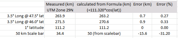
Note the large error from the scale bar (>30% error) and relatively insignificant error on the latitude and longitude measurements (<0.1% error).
Questions:
1. Why would the scale bar length be inaccurate (especially when the image lat-long appear to be projected correctly and can be measured accurately in ArcMap)?
2. Is this an error in my geo-referencing? If so, is there a better method for geo-referencing this type of map image?
3. Am I using an incorrect projection? I believe a projected UTM is appropriate for area calculations and should provide accurate length measurement for features located within the UTM zone.
Any assistance is appreciated. Thanks!
Solved! Go to Solution.
Accepted Solutions
- Mark as New
- Bookmark
- Subscribe
- Mute
- Subscribe to RSS Feed
- Permalink
- Report Inappropriate Content
It's possible whatever software was used to generate the original image calculated the scale bar at the equator (ArcMap used to do this; I don't know if it still does), rather than at 47N. I get 0.68% reduction east-west ( cos(47) ) which ends up being 34 km / 50 km.
If it was a bathymetry chart, it could be using Mercator with a standard parallel set around 47N to reduce distortion. That would also give a rectangular graticule.
Melita
- Mark as New
- Bookmark
- Subscribe
- Mute
- Subscribe to RSS Feed
- Permalink
- Report Inappropriate Content
What is the projection for maps images?
- Mark as New
- Bookmark
- Subscribe
- Mute
- Subscribe to RSS Feed
- Permalink
- Report Inappropriate Content
The map image in question was originally drafted in a geographic coordinate system, but after I geo-referenced it appeared to project correctly in a data frame using a projected UTM coordinate system.
- Mark as New
- Bookmark
- Subscribe
- Mute
- Subscribe to RSS Feed
- Permalink
- Report Inappropriate Content
Just some quick clarification:
- you're talking about the scale bar that came through on the original map, not an ArcMap layout scale bar, correct?
- I assume you've overlaid your georeferenced map over some known correct data to confirm that your georeferencing matches reality.
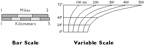
- Have you checked the map for fine print regarding scale (e.g. "scale only applies to such-and-such a latitude") or does it have a variable scale bar?
- Mark as New
- Bookmark
- Subscribe
- Mute
- Subscribe to RSS Feed
- Permalink
- Report Inappropriate Content
I will address your questions in order:
- The scale bar in question is on the original map.
- Yes, I have checked and the georeferenced map with known data (a lat-long grid) and it matches up very well.
- The original map does not have a variable scale. It only ranges from 46 to 47.6 degrees latitude; as a result, a 50 km (non-variable) scale bar should only have an inaccuracy of about 1.5 km within the map area. However, I am observing an error of over 15 km.
- Mark as New
- Bookmark
- Subscribe
- Mute
- Subscribe to RSS Feed
- Permalink
- Report Inappropriate Content
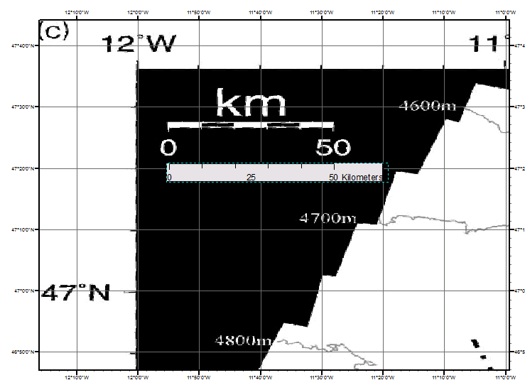
The first image is the corner of the original map projected using a geographic coordinate system (WGS_1984), which shows how well the map lines up with the lat-long grid. The top "50 km" scale bar (from the original map) matches the lower "50 km" scale bar (created in ArcMap layout view). When I measure them with the Measure Tool they are 34.4 km long. Why would the scale bar (even the one created in ArcMap) not be correct length according to the Measure Tool?
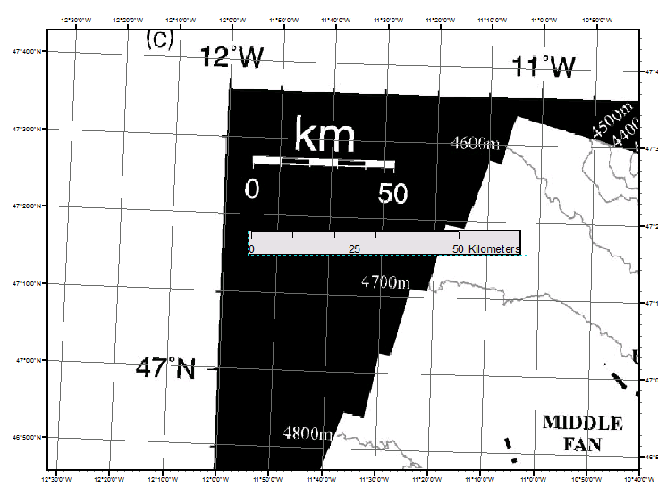
The second image is the same map in a projected coordinate system (UGS_1984_UTM_Zone_29N). Now the scale bars are not aligned. Using the Measure Tool the original "50 km" scale bar again measures 34.4 km, while the ArcMap derived "50 km" scale measures 50 km
What do I need to do to find an accurate / trustworthy length measurement? And after that what settings can be used to calculate areas?
- Mark as New
- Bookmark
- Subscribe
- Mute
- Subscribe to RSS Feed
- Permalink
- Report Inappropriate Content
What do I need to do to find an accurate / trustworthy length measurement? And after that what settings can be used to calculate areas?
You should only start measuring length/area once everything (data and data frame) are in a projected coordinate system. As a compromise projection, UTM distorts both distance and area, so technically you should measure distances using an appropriate equidistant CRS, and areas using an appropriate equal area CRS, but most people use UTM for convenience.
This doesn't answer why this is happening for you, but if you always do your measurements on projected data, you should be fine.
edit: I'll just call over Melita Kennedy, because she can explain this better than anyone I know.
- Mark as New
- Bookmark
- Subscribe
- Mute
- Subscribe to RSS Feed
- Permalink
- Report Inappropriate Content
First, I agree with your point that UTM will distort distance and area. Based on the fact that I will not be measuring areas that extend beyond a single UTM zone (often much smaller and up to a few 100 km), I was considering using a projected UTM for measuring distance and area. Will this method introduce significant error?
Second, is there a simple reason why the relationship between the scale bar from the original map and one created in ArcMap changes when using a projected vs. geographic coordinate system?
Particularly, an explanation for the irregularities when using the "Measure Tool" to check the scales: How can the ArcMap based scale bar be wrong/inconsistent (measuring 34.4 km in the GCS and 50 km in the PCS) and the scale bar from the georeferenced image be consistent in length (34.4 km in both GCS and PCS) but wrong (should be 50 km) (as illistrated in the images in my previous post)?
- Mark as New
- Bookmark
- Subscribe
- Mute
- Subscribe to RSS Feed
- Permalink
- Report Inappropriate Content
Do you have 2 data frame in layout?
perhaps the scale bar for another data frame.
- Mark as New
- Bookmark
- Subscribe
- Mute
- Subscribe to RSS Feed
- Permalink
- Report Inappropriate Content
No, there is only one data frame.