- Home
- :
- All Communities
- :
- User Groups
- :
- Coordinate Reference Systems
- :
- Questions
- :
- Re: Reproject tiles from six different UTM zones
- Subscribe to RSS Feed
- Mark Topic as New
- Mark Topic as Read
- Float this Topic for Current User
- Bookmark
- Subscribe
- Mute
- Printer Friendly Page
- Mark as New
- Bookmark
- Subscribe
- Mute
- Subscribe to RSS Feed
- Permalink
- Report Inappropriate Content
I have GEOTIFF tiles in six different UTM zones(all these tiles have different height and width. They are rectangles No two tiles have the same height and width). I need to project them into Plate Carree.
What is the best way to do this ?
Can I do the inverse projection of each tile into the datum"? Then do a mosaic and then do the forward projection to Plate Carree ?
Or
Project all the tiles into the UTM zone of the first tile and then do a mosaic followed by a projection to Plate Carree ?
My ultimate goal is to cut square tiles out of the mosaic'ed' tile.
Solved! Go to Solution.
Accepted Solutions
- Mark as New
- Bookmark
- Subscribe
- Mute
- Subscribe to RSS Feed
- Permalink
- Report Inappropriate Content
Yes, I can see that they have different utm zones, no problem.
I see that there is a projection definition for a "WGS84 Plate Carree" in the system.
See here..
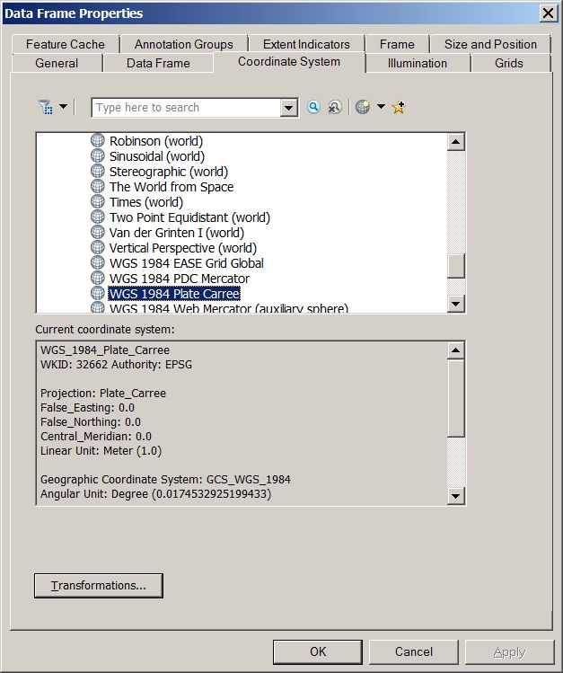
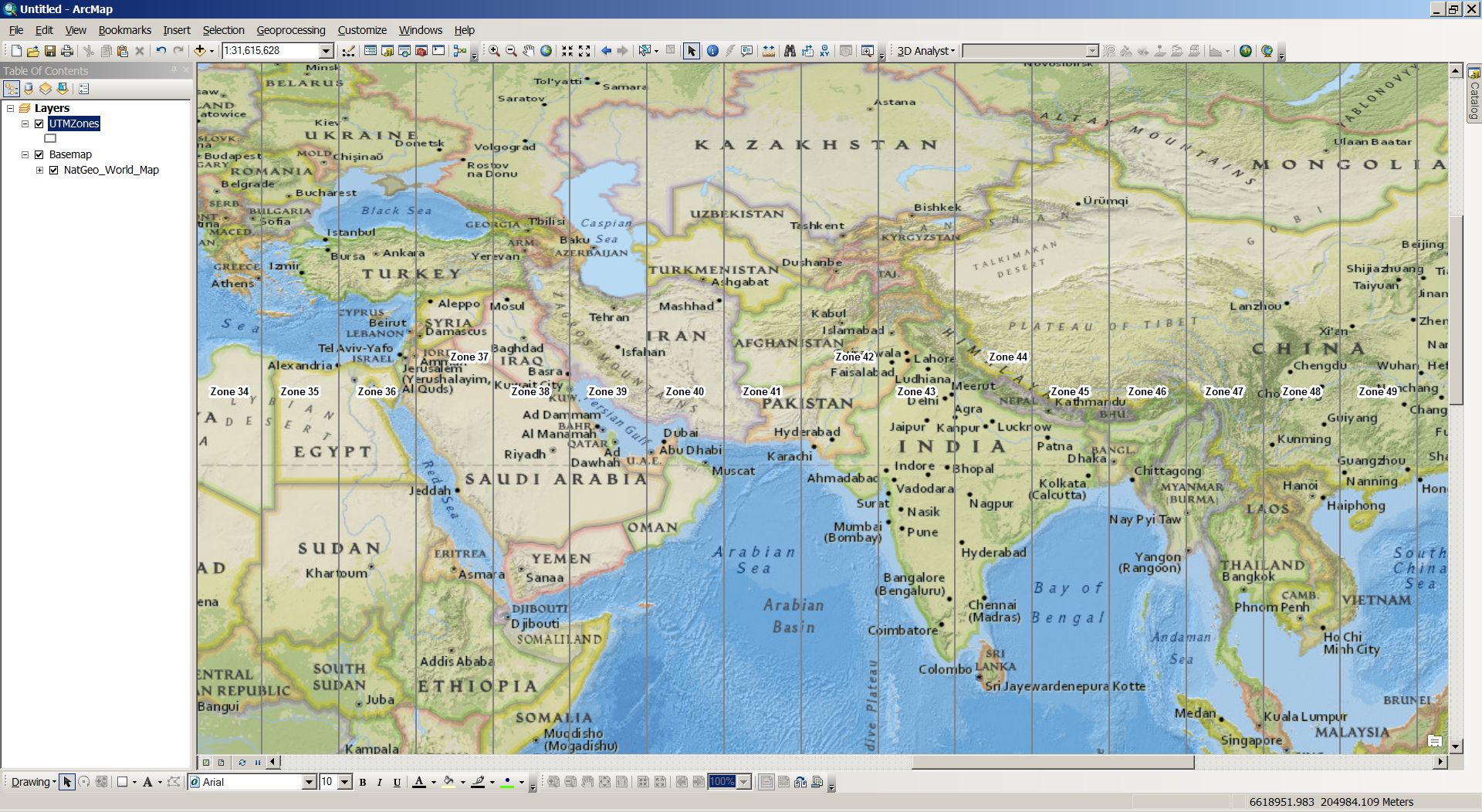
This map is showing the Nat Geo basemap. With the zones on top. It is a little more "stretched" east / west than a typical UTM zone.
If you set up your data frame like this, then add the image tiles, everything will be reprojected into this system.
No datum shift is necessary because both are WGS84 based.
Then you could export them again using the coord sys of the data frame. Or try Jayanta's idea of simply importing them into a mosaic that has its coord sys already defined as WGS84 Plate Carree.
- Mark as New
- Bookmark
- Subscribe
- Mute
- Subscribe to RSS Feed
- Permalink
- Report Inappropriate Content
Hi Aswin,
Try the following:
1) Create a Mosaic Dataset (Data Management). Define the spatial reference as Plate Carree. This will create an empty mosiac dataset.
2) Add the above rasters to the mosaic dataset.
Think Location
- Mark as New
- Bookmark
- Subscribe
- Mute
- Subscribe to RSS Feed
- Permalink
- Report Inappropriate Content
Thanks Jayanta for your response. I think I am can handle the ArcGis part of the implementation.
My question was - I have tiles from six different UTM zones. They are the same type of projection but not the same projection. Their EPSG code numbers are different. How best to mosaic tiles that are not the same projection ?
- Mark as New
- Bookmark
- Subscribe
- Mute
- Subscribe to RSS Feed
- Permalink
- Report Inappropriate Content
What do you mean by :
Can I do the inverse projection of each tile into the datum"? Then do a mosaic and then do the forward projection to Plate Carree ?
A projection and the datum on which it is based are 2 entirely different issues. Re-projections from one GCS/PCS to another is easily achieved using the projection routines in ArcGIS. A datum change is a datum transformation, and will need more research depending on what is available for your data in its area of use.
You have specified your output to be Plate Carree which is a worldwide pcs based on a sphere (not an ellipsoid/spheroid). Why is that?
Is there not a more regional pcs that you can use.
Jayanta has said that once the Mosaic is defined using your output pcs, the input rasters will automatically re-projected on-the-fly into it.
Never tried that before, I have always got my inputs and outputs aligned before building the mosaic.
- Mark as New
- Bookmark
- Subscribe
- Mute
- Subscribe to RSS Feed
- Permalink
- Report Inappropriate Content
Neil - thank you for your response.
In response to your questions
1) Plate Carree is required because that is the projection required by another application. That "other" application is the "consumer" of the data. I do not have much freedom in changing that application at the moment
2) All of my tiles have been projected out of the same datum. So I was thinking if I do a inverse projection to the datum and then project out into Plate Carree that may work. But never mind this. If there is a better way I will be happy to implement it.
3) The regional PCS may work for mosaicing the tiles. That was one of my solutions I proposed. Reproject all tiles into the UTM of the tile belonging to the first UTM zone and then do a projection to Plate Carree.
I have enclosed the gdalinfo output of two sample tiles. As you can EPSG numbers are different for both tiles - hence they are not the same projection.
Coordinate System is:
PROJCS["WGS 84 / UTM zone 42N",
GEOGCS["WGS 84",
DATUM["WGS_1984",
SPHEROID["WGS 84",6378137,298.257223563,
AUTHORITY["EPSG","7030"]],
AUTHORITY["EPSG","6326"]],
PRIMEM["Greenwich",0],
UNIT["degree",0.
0174532925199433],
AUTHORITY["EPSG","4326"]],
PROJECTION["Transverse_Mercator"],
PARAMETER["latitude_of_origin",0],
PARAMETER["central_meridian",69],
PARAMETER["scale_factor",0.9996],
PARAMETER["false_easting",500000],
PARAMETER["false_northing",0],
UNIT["meters",1],
AUTHORITY["EPSG","32642"]]
and
2nd tile -
Coordinate System is:
PROJCS["WGS 84 / UTM zone 43N",
GEOGCS["WGS 84",
DATUM["WGS_1984",
SPHEROID["WGS 84",6378137,298.257223563,
AUTHORITY["EPSG","7030"]],
AUTHORITY["EPSG","6326"]],
PRIMEM["Greenwich",0],
UNIT["degree",0.0174532925199433],
AUTHORITY["EPSG","4326"]],
PROJECTION["Transverse_Mercator"],
PARAMETER["latitude_of_origin",0],
PARAMETER["central_meridian",75],
PARAMETER["scale_factor",0.9996],
PARAMETER["false_easting",500000],
PARAMETER["false_northing",0],
UNIT["meters",1],
AUTHORITY["EPSG","32643"]]
- Mark as New
- Bookmark
- Subscribe
- Mute
- Subscribe to RSS Feed
- Permalink
- Report Inappropriate Content
Yes, I can see that they have different utm zones, no problem.
I see that there is a projection definition for a "WGS84 Plate Carree" in the system.
See here..
This map is showing the Nat Geo basemap. With the zones on top. It is a little more "stretched" east / west than a typical UTM zone.
If you set up your data frame like this, then add the image tiles, everything will be reprojected into this system.
No datum shift is necessary because both are WGS84 based.
Then you could export them again using the coord sys of the data frame. Or try Jayanta's idea of simply importing them into a mosaic that has its coord sys already defined as WGS84 Plate Carree.
- Mark as New
- Bookmark
- Subscribe
- Mute
- Subscribe to RSS Feed
- Permalink
- Report Inappropriate Content
Neil - this solves the problem of projection. Using this approach I can project all my tiles into WSG 84 Plate Carree. But it is only half the problem solved.
If you recall I had written ultimately I need to crop tiles out of the mosaic in such a way that the width equals height.
If I mosaic all the "reprojected" WSG 84 Plate Carree tiles together and then crop tiles of as defined above (width = height) will there be an issue with voids at the edges ?
- Mark as New
- Bookmark
- Subscribe
- Mute
- Subscribe to RSS Feed
- Permalink
- Report Inappropriate Content
Well, when you add your original images into the df as shown above, are there gaps, or overlaps?
If there is marginalia along the sides of the imported images, you will have to define a polygon layer as a cropping layer for the mosaic.
As regards the output tiles, you could define a square polygon grid using Create Fishnet and use that to clip out square tiles.
- Mark as New
- Bookmark
- Subscribe
- Mute
- Subscribe to RSS Feed
- Permalink
- Report Inappropriate Content
The way I would do it is:
1. Create a mosaic dataset and define the projection as the output projection.
2. Load all your tiles to the mosaic dataset (they will reproject on the fly).
3. Change the display order to match the best display.
4. Edit the footprint layer to define the borders of the output raster dataset.
5. In the mosaic dataset properties - change the property -'Always Clip the Raster to its Footprint' to yes.
6. Export the mosaic to a single raster dataset' or use the Split GP Tool to export the mosaic to several tiles.
Good Luck
Yigal