- Home
- :
- All Communities
- :
- User Groups
- :
- Coordinate Reference Systems
- :
- Questions
- :
- Projektion Problem
- Subscribe to RSS Feed
- Mark Topic as New
- Mark Topic as Read
- Float this Topic for Current User
- Bookmark
- Subscribe
- Mute
- Printer Friendly Page
- Mark as New
- Bookmark
- Subscribe
- Mute
- Subscribe to RSS Feed
- Permalink
- Report Inappropriate Content
Hello Everyone,
i have a (maybe real simple) Problem. I want to add Point Data using X/y-Coordinates based on two different excel-tab. As a basement-layer i use official Data UTM Zone 32 (25832). The first adding is no Problem, die x/y Data is given in N and E collum with Values like:
| N | E |
| 2689100 | 4337000 |
| 2689100 | 4341100 |
| 2690800 | 4341200 |
The Documentary says the Data is given in ETRS_1989_LAEA (3035) and its working fine. The second tab now has x/y Data given in that form:
| N | E |
| 4404927,43 | 5539801,47 |
| 4370697,91 | 5544504,58 |
| 4373924,39 | 5547811,9 |
I checked the coordinates using web-tools and the point where located at the right spots using Gauss_Zone_3 (31467). But when i want to add this x/y-Data to my projekt there is always a significant cutoff between my first und the secound data:
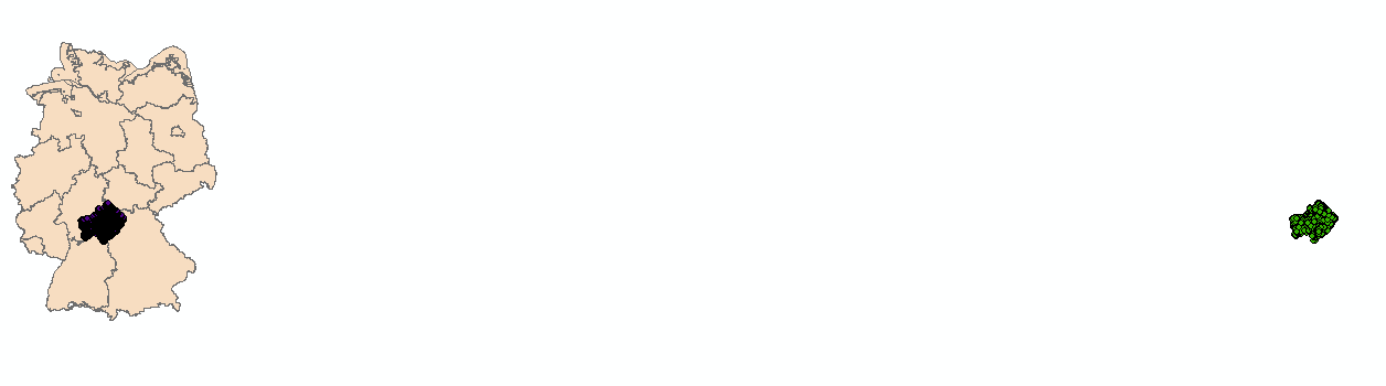
I tryed also different Projektions/Systems but the results stayed the same. Anyone has a idea how to fix this Problem? (iam using ArcGIS 10.5)
Solved! Go to Solution.
Accepted Solutions
- Mark as New
- Bookmark
- Subscribe
- Mute
- Subscribe to RSS Feed
- Permalink
- Report Inappropriate Content
Hi Sebastian,
your second data source is in "DHDN 3-Degree Gauss Zone 4" with the EPSG authority 31468. And it's really important to use the transformation "DHDN_To_ETRS_1989_8_NTv2" for correct projections!
Cheers
Christa
- Mark as New
- Bookmark
- Subscribe
- Mute
- Subscribe to RSS Feed
- Permalink
- Report Inappropriate Content
It worked, thank you Christa.
Just as aditional Information: witch transformation should i use for the first x/y-Dateset to get the same results? There is a slide difference between them
- Mark as New
- Bookmark
- Subscribe
- Mute
- Subscribe to RSS Feed
- Permalink
- Report Inappropriate Content
“Projection on the fly” doesn’t work accurate! The best way is to project both sources by using the project tool into ETRS_1989_UTM_Zone_32N (EPSG 25832). Because of the differences between the basic geoids the points will have retain an inaccuracy about 70 – 120 meter.
Von: S. R.
Gesendet: Dienstag, 4. September 2018 17:28
An: Vinnemann, Christa <Christa.Vinnemann@bgr.de>
Betreff: Re: - Re: Projektion Problem
GeoNet <https://community.esri.com/?et=watches.email.thread>
Re: Projektion Problem
reply from S. R.<https://community.esri.com/people/seb.ra?et=watches.email.thread> in Coordinate Reference Systems - View the full discussion<https://community.esri.com/message/796694-re-projektion-problem?commentID=796694&et=watches.email.thread#comment-796694>
- Mark as New
- Bookmark
- Subscribe
- Mute
- Subscribe to RSS Feed
- Permalink
- Report Inappropriate Content
Christa Vinnemann Projection-on-the-fly for vector data uses the same functions and settings as the Project tool. For rasters, they use zoom-level / map scale to adjust the on-the-fly projection. If you change the map scale or zoom level, the algorithm will adjust.
S. R. What coordinate system if the map using? You can try other DHDN / ETRS89 transformations. Try #3 which is used in your area of use.
Melita