- Home
- :
- All Communities
- :
- User Groups
- :
- Coordinate Reference Systems
- :
- Questions
- :
- Re: How to project an HRAP_Sphere geographic coord...
- Subscribe to RSS Feed
- Mark Topic as New
- Mark Topic as Read
- Float this Topic for Current User
- Bookmark
- Subscribe
- Mute
- Printer Friendly Page
How to project an HRAP_Sphere geographic coordinate system into any other PCS?
- Mark as New
- Bookmark
- Subscribe
- Mute
- Subscribe to RSS Feed
- Permalink
- Report Inappropriate Content
What is the correct way to project an existing shapefile that has a .prj file associated with it containing the following information into any other coordinate system for e.g. web mercator?
GEOGCS["HRAP_Sphere",DATUM["<custom>",SPHEROID["<custom>",6371200.0,0.0]],PRIMEM["Greenwich",0.0],UNIT["Degree",0.0174532925199433]]
A sample shapefile is attached.
Solved! Go to Solution.
Accepted Solutions
- Mark as New
- Bookmark
- Subscribe
- Mute
- Subscribe to RSS Feed
- Permalink
- Report Inappropriate Content
One of my favorite topics...
If you open the Shape File and look at the data, you'll see that the precipitation reports include the HRAP grid cell, meaning that the Point feature in the shape file is only an estimate of the center point of each HRAP grid cell.
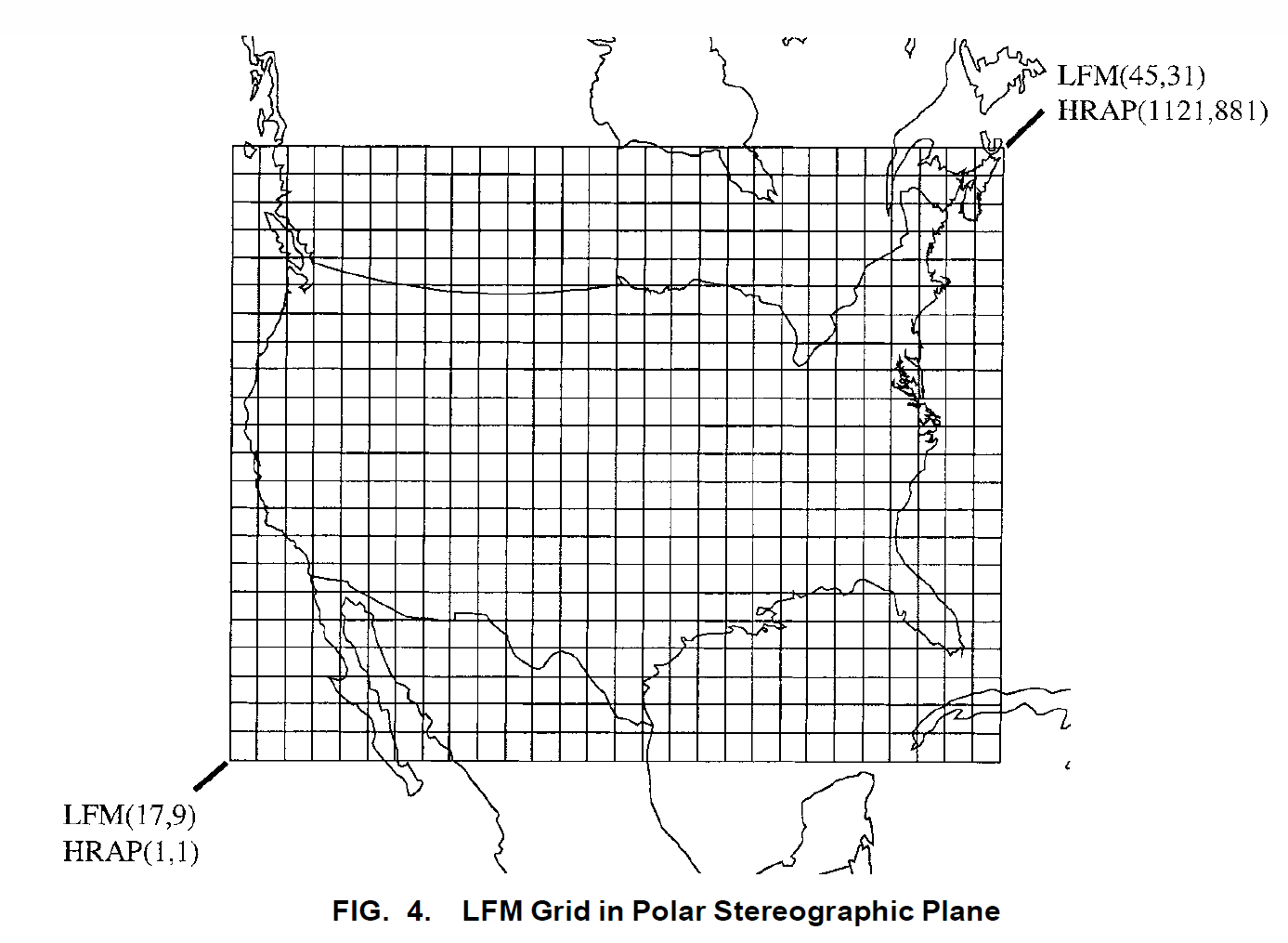
The HRAP grid is drawn from the NWS LFM (Limited Fine Mesh) projection--at 1/40th. This image (Reed & Maidment, 1999) shows the full LFM for CONUS used by NEXRAD reporting in a finer HRAP grid in units 1/40th of LFM.
Some discussion in this old Forums thread HRAP (Hydrologic Rainfall Analysis Projection) Transformation
I've uploaded a copy of R. Fulton WSR-88D Polar-toHRAP Mapping paper here -- Fulton1998_WSR88D-to-HRAP_mapping.pdf
What you really should track down is the Reed & Maidment article "Coordinate Transformations for using NEXRAD Data in GIS-Based Hydrologic Modeling" in the Journal of Hydrologic Engineering. 1999.4:174-182
- Mark as New
- Bookmark
- Subscribe
- Mute
- Subscribe to RSS Feed
- Permalink
- Report Inappropriate Content
It depends on how the data owners produced the data.
1. Try redefining the coordinate system as WGS84 (Define Projection tool)
2. Create a custom geographic transformation between the HRAP_sphere geographic coordinate system and WGS84 using Create Custom Geographic Transformation tool. When defining the transformation, import the HRAP coordinate system as the 'from' GCS and pick Geocentric_Translations for the method. Leave the parameter values set to zeroes.
The difference between methods (1) and (2) is that the 2nd method will convert between the two ellipsoids, but you'll only see values move north-south (in latitude).
Melita
- Mark as New
- Bookmark
- Subscribe
- Mute
- Subscribe to RSS Feed
- Permalink
- Report Inappropriate Content
One of my favorite topics...
If you open the Shape File and look at the data, you'll see that the precipitation reports include the HRAP grid cell, meaning that the Point feature in the shape file is only an estimate of the center point of each HRAP grid cell.
The HRAP grid is drawn from the NWS LFM (Limited Fine Mesh) projection--at 1/40th. This image (Reed & Maidment, 1999) shows the full LFM for CONUS used by NEXRAD reporting in a finer HRAP grid in units 1/40th of LFM.
Some discussion in this old Forums thread HRAP (Hydrologic Rainfall Analysis Projection) Transformation
I've uploaded a copy of R. Fulton WSR-88D Polar-toHRAP Mapping paper here -- Fulton1998_WSR88D-to-HRAP_mapping.pdf
What you really should track down is the Reed & Maidment article "Coordinate Transformations for using NEXRAD Data in GIS-Based Hydrologic Modeling" in the Journal of Hydrologic Engineering. 1999.4:174-182
- Mark as New
- Bookmark
- Subscribe
- Mute
- Subscribe to RSS Feed
- Permalink
- Report Inappropriate Content
Thanks Stuart Foote. This really helps, though yet to get my hands on the Reed and Maidment article.
An HRAP grid cell is 4 x 4 km and the points in the shapefile are the center of each cell right? So, I was wondering if I just redefine the coordinate system to WGS84 and use it further, what would be the magnitude of error?
My objective is mainly to visualize the precipitation (interpolate, smooth and vectorize into polygons) and not use it further in any hydrological models or analysis. Well, it may be used sometimes to estimate what's the affected population in case of a storm though. Do you think assuming it to WGS84 will introduce too much error?