- Home
- :
- All Communities
- :
- User Groups
- :
- Coordinate Reference Systems
- :
- Questions
- :
- How to correct parcels off by 30 meters?
- Subscribe to RSS Feed
- Mark Topic as New
- Mark Topic as Read
- Float this Topic for Current User
- Bookmark
- Subscribe
- Mute
- Printer Friendly Page
How to correct parcels off by 30 meters?
- Mark as New
- Bookmark
- Subscribe
- Mute
- Subscribe to RSS Feed
- Permalink
- Report Inappropriate Content
Hello ESRI community,
I am working with a number of layers which depict a county in North Carolina. I have roads, floodway, parcels, etc. I am using NC state plane (feet) as the projection.
My issue: the parcels layer for one of the counties seems to be approximately 30 meters southwest of the rest of the data. (measured between the features themselves)
The parcels layer of issue is in the same projection and GCS as all the other layers. One can see the issue below....
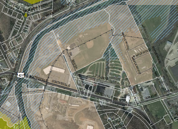
you can see how the bridge in the west should fit nicely in the gap of parcels ... and also how Beech road should fit in the space to the west as well.
The extent for the parcels is 985692.937598 ft top, 1449593.500033 ft right, 824972.250182 ft bottom, and 1248152.624849 ft left.
The extent for the county as provided by TIGER shapefile data from the Census Bureau is 985743.531657 ft top, 1449459.168757 ft right, 825065.010167 ft bottom, 1248233.826458 ft left
I greatly appreciate your help!
Solved! Go to Solution.
Accepted Solutions
- Mark as New
- Bookmark
- Subscribe
- Mute
- Subscribe to RSS Feed
- Permalink
- Report Inappropriate Content
Do you know the source of the Parcel feature class? It is possible that it was projected to the same coordinate system as the other features by someone without using the correct transformation method. If that happened, you want to go back to the original data and re-project it using the proper transformation method.
- Mark as New
- Bookmark
- Subscribe
- Mute
- Subscribe to RSS Feed
- Permalink
- Report Inappropriate Content
I do not know the source of the data - but it's likely that the county provided the data.
Since I know the proper extent and the current extent, wouldn't there be some way to simply translate the parcels?
- Mark as New
- Bookmark
- Subscribe
- Mute
- Subscribe to RSS Feed
- Permalink
- Report Inappropriate Content
Oh wonderful! You were completely correct. I applied a different transformation method and the parcels came right in line.
- Mark as New
- Bookmark
- Subscribe
- Mute
- Subscribe to RSS Feed
- Permalink
- Report Inappropriate Content
I second what Joseph Segretto suggested - at first glance this looks like a Datum shift. While I'm not familiar with North Carolina data, we have a similar shift here in California when data is in CA State Plane NAD 27 vs. CA State Plane NAD 83. I'd verify the coordinate reference system applied to the data to ensure it is the correct one, and that the correct Datum Transformation was applied if the data does not share the same coordinate reference system.
Chris Donohue, GISP