- Home
- :
- All Communities
- :
- User Groups
- :
- Coordinate Reference Systems
- :
- Questions
- :
- Geographic Transformations & ERROR 000365: Invalid...
- Subscribe to RSS Feed
- Mark Topic as New
- Mark Topic as Read
- Float this Topic for Current User
- Bookmark
- Subscribe
- Mute
- Printer Friendly Page
Geographic Transformations & ERROR 000365: Invalid geographic transformation
- Mark as New
- Bookmark
- Subscribe
- Mute
- Subscribe to RSS Feed
- Permalink
- Report Inappropriate Content
I am trying to project a feature class from NAD 1983 (WKID 4269) to The World From Space (WKID 102038).
I can't find a geographic transformation to accomplish this. Is it even possible? I have used the Geographic Transformations PDF to attempt to figure it out, but to no avail.
Any help would be greatly appreciated!
- Mark as New
- Bookmark
- Subscribe
- Mute
- Subscribe to RSS Feed
- Permalink
- Report Inappropriate Content
ERROR 000365: Invalid geographic transformation. Ignore the goof in spelling it should be NAD83 to WGS84
- Mark as New
- Bookmark
- Subscribe
- Mute
- Subscribe to RSS Feed
- Permalink
- Report Inappropriate Content
Thanks for the help. But when using "NAD_1983_To_WGS_1984_1" as the geographic transformation, I'm now getting a different error.
ERROR 000151: The geotransformation(s) is not valid.
- Mark as New
- Bookmark
- Subscribe
- Mute
- Subscribe to RSS Feed
- Permalink
- Report Inappropriate Content
Sorry, so are you talking about data which in in GCS (geographic coordinates) based on NAD83 and "projecting it", presumably in the data frame, to a "World from Space" representation?
I don't think that any geographic transformation (shifting of the datum) is appropriate. And if you are seeking to get NAD83 based coords onto WGS84, the difference between them at world wide scale would be microscopic.
- Mark as New
- Bookmark
- Subscribe
- Mute
- Subscribe to RSS Feed
- Permalink
- Report Inappropriate Content
Yes...I think....
I have a data set with a defined coordinate system of NAD83 and then I am running the Project tool (Data Management > Projections and Transformations > Feature > Project) to project it as The World From Space. This is when I am getting the different errors depending on which geographic transformation I try. Also, I have tried running it without a geographic transformation (defining a geographic transformation is technically optional), but the tool will not run unless I define a transformation.
- Mark as New
- Bookmark
- Subscribe
- Mute
- Subscribe to RSS Feed
- Permalink
- Report Inappropriate Content
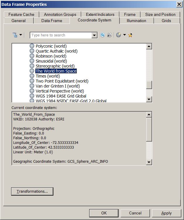
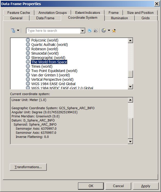
I see that World from Space is based upon an old ArcInfo sphere model. So, no, a geographic transformation is neither necessary or appropriate. I am surprised that the system even gives you an option to select one.
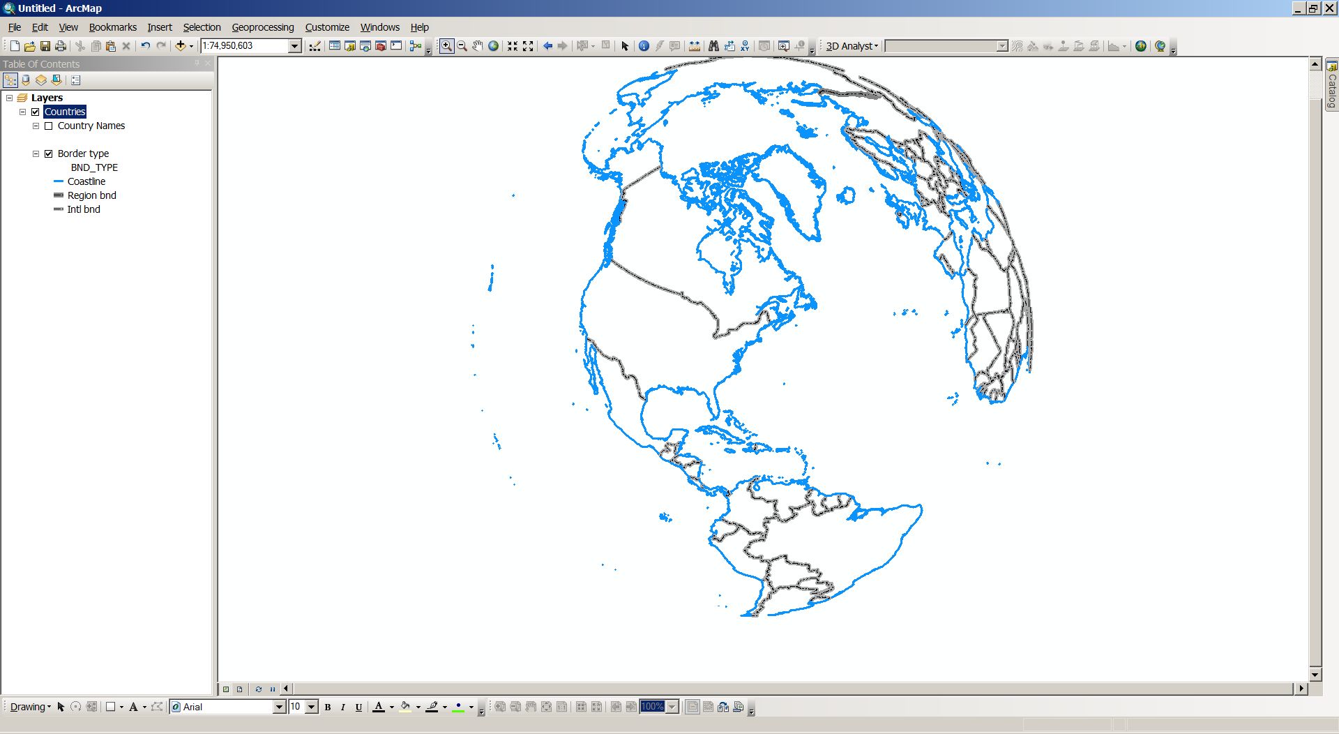
In the third pic below, a GCS based world countries dataset, projected to WfromS by changing the df properties.
It does takes ages to draw though.
Hope this helps.
- Mark as New
- Bookmark
- Subscribe
- Mute
- Subscribe to RSS Feed
- Permalink
- Report Inappropriate Content
Now that Neil Ayres has the data displaying[1], you can export the layer using World from Space.
- Right-click the layer in the table of contents.
- Select Data, Export Data
- In the Export dialog, choose the data frame's coordinate system option.
[1] oblique orthographic has a complex "horizon" (valid area of the projection in lat/lon coordinates) so the drawing delay is due to the clipping of the polygons.