- Home
- :
- All Communities
- :
- User Groups
- :
- Coordinate Reference Systems
- :
- Questions
- :
- Re: CA State Plane to CA Teale Albers converts fal...
- Subscribe to RSS Feed
- Mark Topic as New
- Mark Topic as Read
- Float this Topic for Current User
- Bookmark
- Subscribe
- Mute
- Printer Friendly Page
CA State Plane to CA Teale Albers converts false northing ft-->m
- Mark as New
- Bookmark
- Subscribe
- Mute
- Subscribe to RSS Feed
- Permalink
- Report Inappropriate Content
I have a raster in NAD83 CA State Plane Zone II (US feet) that I need to project to NAD83 CA Teale Albers (US feet). When I run the project raster tool, the false northing on the output raster changes from -4,000,000 (what it should be per the .prj file) to -13,123,333.3333. The difference between the two numbers is a factor of 3.28 so my guess this is a feet to meters issue.
The values of the original raster (the one in SP) are in feet. The spatial reference properties are:
Spatial reference: NAD_1983_StatePlane_California_II_FIPS_0402_Feet
Linear Unit: Foot_US (0.304801)
Angular Unit: Degree (0.0174532925199433)
false_easting: 6561666.666666666
false_northing: 1640416.666666667
central_meridian: -122
standard_parallel_1: 38.33333333333334
standard_parallel_2: 39.83333333333334
latitude_of_origin: 37.66666666666666
Datum: D_North_American_1983
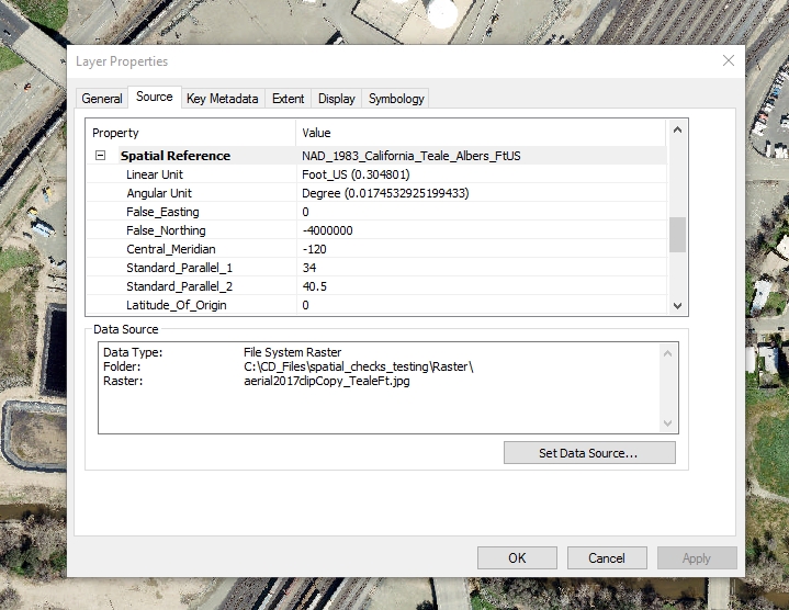
The spatial reference properties that the projected raster SHOULD have:
Spatial reference: NAD_1983_California_Teale_Albers_FtUS
Linear Unit: Foot_US (0.304801)
Angular Unit: Degree (0.0174532925199433)
false_easting: 0
false_northing: -4000000
central_meridian: -120
standard_parallel_1: 34
standard_parallel_2: 40.5
latitude_of_origin: 0
Datum: D_North_American_1983
When I run the tool on the original raster, the spatial reference properties that the raster ends up having:
Spatial reference: NAD_1983_California_Teale_Albers_FtUS
Linear Unit: Foot_US (0.304801)
Angular Unit: Degree (0.0174532925199433)
false_easting: 0
false_northing: -13123333.33333333
central_meridian: -120
standard_parallel_1: 34
standard_parallel_2: 40.5
latitude_of_origin: 0
Datum: D_North_American_1983
The resulting raster ends up somewhere in northern Canada. Certainly no offense to Canada, but I need my data to be in Sonoma County. Any ideas on why -4000000 is being converted to -13123333.3333?
- Mark as New
- Bookmark
- Subscribe
- Mute
- Subscribe to RSS Feed
- Permalink
- Report Inappropriate Content
the central meridian and standard parallels between the first and the last two examples are also completely different. Beyond the feet to meters that you have noted, why the shift in those values? Is there more than one teale albers for CA?
- Mark as New
- Bookmark
- Subscribe
- Mute
- Subscribe to RSS Feed
- Permalink
- Report Inappropriate Content
Thanks for your reply. The first example is the State Plane projection that the data currently has. The data with this projection appears in the correct place in space. I would like to project the data to Teale Albers (there's only one for CA), so you'd expect the central meridian and standard parallels to change with the new projection, correct?
The units for the State Plane and Teale Albers projections I'm moving between are both feet. I'm grappling to understand why the tool thinks that it needs to convert the false northing from meters to feet. It seems there would be some indication that some property of the original data (the one in State Plane) is in meters, but I'm not seeing that.
- Mark as New
- Bookmark
- Subscribe
- Mute
- Subscribe to RSS Feed
- Permalink
- Report Inappropriate Content
This definitely seems odd. I wonder if the projection engine is corrupted, maybe? The reason I speculate on this is I just ran our City aerial (Roseville California, CA State Plane 2 NAD 83) through a Project Raster (Data Management) geoprocessing tool set to Teale Albers NAD 83 feet and it worked fine. The resultant image lands where it is expected to when brought into a mxd.
What version of ArcGIS are you using (I'm on ArcGIS Desktop 10.4.1)? Or is ArcGIS Pro being employed?
If you have ESRI Support, it might be worth it to check with them, as this seems unusual.
Resultant image settings after Project Raster:
Chris Donohue, GISP
- Mark as New
- Bookmark
- Subscribe
- Mute
- Subscribe to RSS Feed
- Permalink
- Report Inappropriate Content
I would follow Chris's suggestion, something shouldn't change the standard parallels and if that projection worked for him, then I would step back to the beginning making no assumptions about what is correct and proceed from there.
- Mark as New
- Bookmark
- Subscribe
- Mute
- Subscribe to RSS Feed
- Permalink
- Report Inappropriate Content
Thanks, Chris and Dan. I'm running 10.2.1. I tried it on another machine that has 10.3 and got the same result. I suspect something is wrong with the original raster in SP. The raster is a modeling result file from the US Army Corps HEC-RAS software. I didn't have this problem on another project where I also had to convert RAS output from SP Zone II to Teale Albers which makes this an even greater mystery. I went back and rebuilt the problem raster from scratch (checked that all my inputs were in SP feet, re-ran model, re-exported raster) and still got the same result. My next step will be to project all the model inputs to Teale Albers, re-run the model in Teale Albers, and hope that I get usable output.
- Mark as New
- Bookmark
- Subscribe
- Mute
- Subscribe to RSS Feed
- Permalink
- Report Inappropriate Content
I am having the same problem, where the spatial reference is defaulting my false easting and northing values. My project data is supposed to include false easting, northing 1968500 , 13123333.3333~ but it defaults to 600000, 4000000 and the software wont let me change it. I am running ArcMap 10.6.1. I tried it at my work where we use ArcMap 10.2 and it worked fine. One thing to note also is that ArcCatalog allowed me to change the spatial reference at my work. However, at home using ArcMap 10.6.1 that it wont allow me to change the spatial reference. and Yes I checked that the folder is not read only. Any suggestions. It is fascinating that ArcMap 10.2 got it right....
- Mark as New
- Bookmark
- Subscribe
- Mute
- Subscribe to RSS Feed
- Permalink
- Report Inappropriate Content
Hi Peter,
I have run into the same problem with a raster file generated by HEC-RAS. I have the HEC-RAS project working in the Teale (California) Albers Projection but when I export the RASTER file into ArcGIS, the false northing of the coordinate system has changed with no reason to that value -13123333.3333.
May I ask, did you ever find out the reason of this problem? If not, what did you do to make it work?
I was thinking about running the HEC-RAS model in another coordinate system, and then make the projection in ArcGIS.
I would appreciate your help very much.
-Leonardo
- Mark as New
- Bookmark
- Subscribe
- Mute
- Subscribe to RSS Feed
- Permalink
- Report Inappropriate Content
Did anyone find a solution for this issue?
Out of curiosity, are all or most of you working on dam inundation map submittals for the California Division of Safety of Dams (DSOD)? The reason why I ask this is because I noticed the combination of California Teale Albers and HEC-RAS output references.
I am working on a dam inundation map submittal and ran into this projection problem, specifically for tif files. HEC-RAS exports vrt and tif files. The vrt file has the correct -4000000 false northing and appears in the correction location, but the tif file of the same data has the incorrect -13123333.33333333 false northing. I tried converting the vrt file directly to a tif file; the resulting tif file had the same incorrect false northing. I then tried converting the vrt file to a GRID file. The GRID file had the correct false northing and appeared in the correct location. However, when I then converted this GRID file to a tif file the resulting tif file had the incorrect false northing.
The issue seems to be with how ArcMap reads the tif file and applies this specific projected coordinate system.
I checked the recently updated DSOD website at https://fmds.water.ca.gov/webgis/?appid=dam_prototype_v2# and noticed that the downloadable raster data for the applicable dams are all in file geodatabases.
A file geodatabase raster seems to be able to store this projected coordinate system correctly whereas a separate tif raster seems unable to store it correctly so using a file geodatabase seems to be one solution.
- Mark as New
- Bookmark
- Subscribe
- Mute
- Subscribe to RSS Feed
- Permalink
- Report Inappropriate Content
I too have just come across this issue when working with data touched by HEC-RAS, and, perhaps not coincidentally, with California dam failure inundation maps. But I do wonder if this is actually stemming from incorrect projection definitions bundled with ArcGIS.
Consider a similar case: the state of Wisconsin's preferred projection. It's right above California's Teale Albers projections in the coordinate system list in ArcGIS. Have a look at the False Easting and False Northing values for:
- NAD 1983 (2011) Wisconsin TM (Meters)
- NAD 1983 (2011) Wisconsin TM (US Feet)
Click between the two of them several times. You will see that the False Easting and False Northing parameters are different between them. I didn't break out a calculator to verify but they sure look like they're different by a factor of, oh, 3.28 or so.
Now go down the list and have a look at the False Easting and False Northing parameters for:
- NAD 1983 California (Teale) Albers (Meters)
- NAD 1983 California (Teale) Albers (US Feet)
Again, click between the two of them several times. You will see that the False Easting and False Northing parameters are the same between them. (Well, see the easting is 0, so of course multiplying it by any factor would make it be the same, but the northing is also the same between them, a nice round number, minus four million).
So apparently the False Easting is supposed to be specified in the linear units of the projection. Somebody at either ESRI or the US Army Corps of Engineers (the folks behind HEC-RAS), or the European Petroleum Survey Group (EPSG) misunderstood the measurement units required for these parameters in the projection.