- Home
- :
- All Communities
- :
- User Groups
- :
- Coordinate Reference Systems
- :
- Questions
- :
- Re: utm 6x6 to gauß-krüger (or utm 6x7)?
- Subscribe to RSS Feed
- Mark Topic as New
- Mark Topic as Read
- Float this Topic for Current User
- Bookmark
- Subscribe
- Mute
- Printer Friendly Page
utm 6x6 to gauß-krüger (or utm 6x7)?
- Mark as New
- Bookmark
- Subscribe
- Mute
- Subscribe to RSS Feed
- Permalink
- Report Inappropriate Content
Hello,
i'm not new with coordinate systems, but for the first time i got data in utm 6x6, means 6 numbers & 6 numbers. i only know the utm 6x7...
can someone please tell me, which coordinate system i should choose for projection? (as you know, one has to tell GIS which coordinate system the shape you want to project has...)
normally when i turn utm 6x7 to gauß-krüger i choose (under "projected coordinate systems / utm / other gcs") the "etrs 1989 utm zone 32N".
so which is the name for the utm 6x6?
thank you very much 
- Mark as New
- Bookmark
- Subscribe
- Mute
- Subscribe to RSS Feed
- Permalink
- Report Inappropriate Content
Normally the data provided already has a spatial reference defined. In your case it seems the data does not come with a spatial reference and you want to define the projection to be able to use the data. In case you can contact the provider of the data to obtain more information on the spatial reference, then that would be best.
If that is not possible and you have to derive somehow what the spatial reference is, this may be a bit more complex. You mention you normally work with ETRS89 / UTM zone 32N: EPSG Projection -- Spatial Reference and the Y values are 7 numbers (above 1000000). If you apply this SR to the data, they will appear in Central Africa, which is probably not what you want.
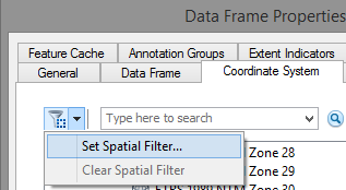
If you know where the data is located you can zoom in to the area using a base map or some layer with a correct SR and filter the coordinate systems by the current visible extent. For example, Data Frame properties, Coordinate System tab, Set Spatial Filter:
and:
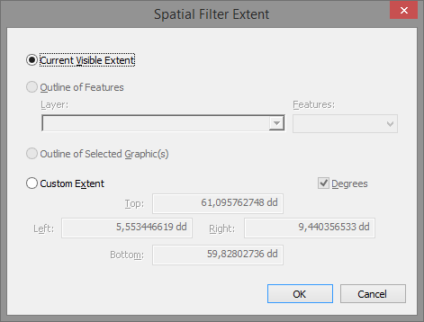
This will reduce the number of spatial references and only show those that apply to the current extent.
For instance if your area is in Norway, you can zoom in to that area, filter the spatial references by the visible extent and revise for instance the National Grids. What you want to look for is a spatial reference that has a Latitude of Origin other than 0°. A latitude of origin of 0° will yield these high Y values in when you are far away from the equator.
For instance ETRS 1989 NTM Zone 6:
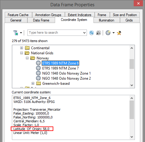
In this case the Latitude of Origin is 58°, which means that at 58°N the Y value will be assigned the False Northing of 1000000.
I will mention Melita Kennedy who is an expert in this field and maybe she can help you out.
- Mark as New
- Bookmark
- Subscribe
- Mute
- Subscribe to RSS Feed
- Permalink
- Report Inappropriate Content
thank you very much for your help