- Home
- :
- All Communities
- :
- User Groups
- :
- Coordinate Reference Systems
- :
- Questions
- :
- Re: Coordinate systems not lining up
- Subscribe to RSS Feed
- Mark Topic as New
- Mark Topic as Read
- Float this Topic for Current User
- Bookmark
- Subscribe
- Mute
- Printer Friendly Page
Coordinate systems not lining up
- Mark as New
- Bookmark
- Subscribe
- Mute
- Subscribe to RSS Feed
- Permalink
- Report Inappropriate Content
Hi there,
I am trying to line up a US Census Block shapefile with another shapefile that has lat/long points, but the points are not lining up with the Census shapefile.
Here is some info that i can offer:
The census file is in WGS 1984 Web Mercator Auxiliary Sphere
The points shapefile is in an unprojected lat/long
I have projected the Points shapefile to GCS_WGS_1984
I have projected the Census shapefile to WGS 1984, WGS Web Mercator, NAD 1983, NAD 1983 Albers.
In most scenarios, the points shapefile is either really really small in the center of the map, or off to the side and kind of tilted.
Id be happy to offer anymore info if needed. Thanks so much!
- Mark as New
- Bookmark
- Subscribe
- Mute
- Subscribe to RSS Feed
- Permalink
- Report Inappropriate Content
Couple of things you might want to check: See if your point data has any 'orphan' records. Those that don't have geometry. Also, check the the feature extent of the points. It may require a recalculation. (ArcCatalog, right click on feature class, select properties, Feature Extent tab)
- Mark as New
- Bookmark
- Subscribe
- Mute
- Subscribe to RSS Feed
- Permalink
- Report Inappropriate Content
thanks, I checked for that but dont have any orphan records. The points shapefile was made by converting a .csv with lat/long info and exported as a shapefile.
However, the feature extents are not alike at all. I attached both of them. I recalculated them but nothing changed. Any idea what to do?
Census blocks feature extent
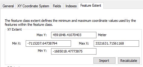
Data Type: Shapefile Feature Class
Shapefile: C:\Users\US_blck_grp_2010.shp
Geometry Type: Polygon
Coordinates have Z values: No
Coordinates have measures: No
Projected Coordinate System: WGS_1984_Web_Mercator_Auxiliary_Sphere
Projection: Mercator_Auxiliary_Sphere
False_Easting: 0.00000000
False_Northing: 0.00000000
Central_Meridian: 0.00000000
Standard_Parallel_1: 0.00000000
Auxiliary_Sphere_Type: 0.00000000
Linear Unit: Meter
Geographic Coordinate System: GCS_WGS_1984
Datum: D_WGS_1984
Prime Meridian: Greenwich
Angular Unit: Degree
Points shapefile feature extent
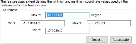
Data Type: Shapefile Feature Class
Shapefile: C:\Users\XYrawCA_GISselection.shp
Geometry Type: Point
Coordinates have Z values: No
Coordinates have measures: No
Geographic Coordinate System: GCS_WGS_1984
Datum: D_WGS_1984
Prime Meridian: Greenwich
Angular Unit: Degree
- Mark as New
- Bookmark
- Subscribe
- Mute
- Subscribe to RSS Feed
- Permalink
- Report Inappropriate Content
There is also the chance that Define Projection was used rather than the Project tool. If that is the case, undo what was done and correct it. In order for anything to be projected, it has to have a properly defined coordinate system first.
- Mark as New
- Bookmark
- Subscribe
- Mute
- Subscribe to RSS Feed
- Permalink
- Report Inappropriate Content
Thanks, definitely "defined projection" for the points shapefile. it appears properly, but is off to the left and extremely zoomed in.
- Mark as New
- Bookmark
- Subscribe
- Mute
- Subscribe to RSS Feed
- Permalink
- Report Inappropriate Content
If it is defined correctly, calculate the X, Y coordinates. Sometimes, people swap the Longitude (should be X) and Latitude (should be Y) or forget that longitude is negative in the western hemisphere and latitude is negative in the southern hemisphere.
If things are still out of whack, then you may have a bad geometry as Joe suggests and/or you need to recalculate the spatial index of the file.
A quick test... open a new data frame. Add one file. Zoom to full extent, if the file appears fine, then it may be good.
Delete that data frame, Open a new one, add the other file... repeat above. if it appears fine, then it may be good.
If you create a 3rd data frame and add the two files together and zoom to full extent and things go bad... then one of the files has had its coordinate system incorrectly defined
- Mark as New
- Bookmark
- Subscribe
- Mute
- Subscribe to RSS Feed
- Permalink
- Report Inappropriate Content
Yup, when I open each file it works fine. When I add them together things get screwy. I updated my reply to Jon above wth my two spatial indexes. Do the two shapefiles need to have the same spatial index? I tried rebuilding both of them but it didnt change anything in ArcMap (even when reloaded)
- Mark as New
- Bookmark
- Subscribe
- Mute
- Subscribe to RSS Feed
- Permalink
- Report Inappropriate Content
Your shapefile has quite a wide extent, unless you are covering a huge E-W extent then you may have point that is off. Calculate the Longitude values and see if one is indeed there
- Mark as New
- Bookmark
- Subscribe
- Mute
- Subscribe to RSS Feed
- Permalink
- Report Inappropriate Content
The points data look better to me than the census data. I think the problem is with the census data. The coordinate extent doesn't look like web Mercator to me. Census data is almost always in latitude-longitude. I can see someone putting it into Web Mercator because they plan to make a web map out of it, but that means the data has had some processing.
If you add it by itself to ArcMap, try switching the display units to decimal degrees (map properties, General tab). The status bar at the bottom of the map will now display lat/lon values. Do they make sense? AKA southern California is around -118 34, Miami around -80 26, and Chicago around -87 42?
If they don't, then the coordinate system is incorrectly defined. If you used the Project Tool to get to this point, the previous coordinate system was probably also incorrect.
EDIT - Took a look at the census extents
Here's the equivalent extents in longitude, latitude order:
-63.91699778984197 -14.96371239524974
29.83872538339628 38.08788461002423
The longitude values are in the Atlantic and the latitude values don't even cover the entire lower 48 states.
As I mentioned earlier, if you don't have the original census data file, try using the Project Tool to go back to its previous coordinate system and please post those values (and the coordinate system).
If you want to send me either or both files, I can take a look at them.
Melita
mkennedy at esri dot com