- Home
- :
- All Communities
- :
- User Groups
- :
- Coordinate Reference Systems
- :
- Questions
- :
- Coordinate reference systems
- Subscribe to RSS Feed
- Mark Topic as New
- Mark Topic as Read
- Float this Topic for Current User
- Bookmark
- Subscribe
- Mute
- Printer Friendly Page
Coordinate reference systems
- Mark as New
- Bookmark
- Subscribe
- Mute
- Subscribe to RSS Feed
- Permalink
I am currently doing some exercises to better understand GCS (Geographic Coordinate Systems) and PCS (Projected Coordinate Systems) using data from Hawaii (the whole state, including all the islands). I chose this data since it spans two UTM zones.
Which GCS would I use?
GCS_Old_Hawaiian or
GCS_Old_Hawaiian_Intl_1924 ?
I downloaded data from the state of Hawaii and they are using NAD83. How does an organization choose which GCS to use when there are various ones? Would the state of Hawaii use NAD83 in this case because it is the most recent one? (If this is the reason, what is the purpose of still having the option in GIS to convert to earlier datums, such as NAD27, for example?)
In addition, would I use the Hawaii_Albers_Equal_Area_Conic as PCS? The data I downloaded show NAD83 UTM Zone 4, which I found strange since the whole state spans two zones (Zone 4 and 5). Is it incorrect in this case?
- Mark as New
- Bookmark
- Subscribe
- Mute
- Subscribe to RSS Feed
- Permalink
Ennina,
These are some good questions. I am not fully sure how to best answer them, but it might be good to have someone from Hawaii weigh in to see what they do about this. I am not sure how many Hawaiians are on GeoNet but I am tagging: Kauai Island GIS User Group (KUG - Kauai, Hawaii) and Pacific User Conference
Also tagging Melita Kennedy
- Mark as New
- Bookmark
- Subscribe
- Mute
- Subscribe to RSS Feed
- Permalink
I'm tagging someone who works in the Honolulu regional office and who's helped me in the past with Hawaiian coordinate system issues. He may not be active on GeoNet though.
GCS_Old_Hawaiian or
GCS_Old_Hawaiian_Intl_1924 ?
This is an odd case. Old Hawaiian uses the Clarke 1866 ellipsoid, which the US Coast and Geodetic Survey, now National Geodetic Survey, used for everything starting in the early 20th century (at least) up until the 1980s. In this case, from what I understand the US military used the International 1924 (aka Int'l 1909 aka Helmert 1909) as the ellipsoid for "Old Hawaiian". So the Int'l 1924 version is very rare, and I've only see data that used it once or twice in over 20 years.
If you're using current data, you wouldn't choose either of these. That data would be on NAD 1983 HARN or NAD 1983 (PA11) or NAD 1983 (PACP00) or possibly NAD 1983. "NAD 1983" is getting more and more problematic because keep using it, but their data is really on a more recent realization/re-adjustment. NAD 1983 should be used for data referenced the original, released in 1986, GCS. But tons and tons of data is defined using it.
Someone decides which geographic coordinate system to use based on a number of factors:
1. How much data already exists in a particular GCS
2. Customer/partner requests/usage
3. Law or statute
4. Accuracy requirements and/or data accuracy
You might be compiling data or a map for a customer or an agency--they'll have chosen what coordinate system they want (hopefully). There are states or local areas which have mandated via statute or law the use of a particular coordinate system or systems. I know of a big federal agency in Alaska which refused to move from NAD27 because they didn't have the money to convert all the existing data.
If you've got landuse data and its accuracy is around 1m, then it doesn't matter if which one of NAD 1983, HARN, PA11, PACP00 is used.
If you're digitizing a old map, you can georeference it directly to a recent GCS-based PCS, but if you can georeference it to its native coordinate system, that's better. Or if you're using older data, perhaps for comparisons over time, over because it's the only data available, you may need to reproject data from or to the older coordinate system.
Esri defined the Albers system, so it was not officially defined by the Hawaiian government. I think they decided to standardize on the zone 4 because the majority of the islands are within zone 4. The big island (Hawaii) is only out by 1.25 degrees. UTM is conformal so shapes are correct. Whether you went with Albers or UTM 5, or a custom transverse Mercator or oblique Mercator should depend more on what type of analysis or purpose that you're doing.
Melita
- Mark as New
- Bookmark
- Subscribe
- Mute
- Subscribe to RSS Feed
- Permalink
Thanks for the very detailed reply Melita Kennedy
- Mark as New
- Bookmark
- Subscribe
- Mute
- Subscribe to RSS Feed
- Permalink
Eninna - I see two questions in your post. One question is what PCS/GCS should you use and Melita has answered that.
Your other question was about some of the statewide data you have being all in UTM Zone 4. You're asking can that be correct since the main 8 Hawaiian island span both UTM Zone 4 and UTM Zone 5. The answer is yes, and here's why.
Many years ago, before map services, when most data was downloaded, the State of Hawaii GIS Program decided to use UTM Zone 4 for their published data. This made it simpler as there was a single file that would cover the entire State. Otherwise, you end up with most of the State and a small piece of Big Island in UTM Zone 4 and a small piece of Maui and most of Big Island in UTM Zone 5. Mathematically the data can be re-projected as needed as long as it is documented so the end user knows.
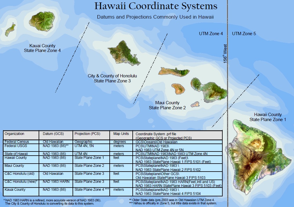
Here's a quick reference we put together a few years back for Hawaii:
Royce
- Mark as New
- Bookmark
- Subscribe
- Mute
- Subscribe to RSS Feed
- Permalink
Thank you, Royce!
I know you've sent me that image before, but I completely forgot about it.